I googled it, but none of the answers given (that I read) seemed to fit.
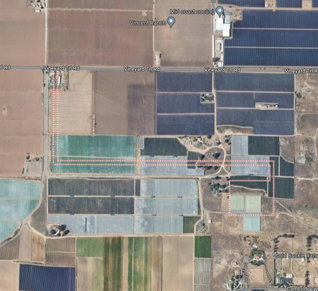
ETA: Closer view

I googled it, but none of the answers given (that I read) seemed to fit.
ETA: Closer view
I think it is just showing the building(s) that the street address is associated with when it might not be obvious. The address for that collection of structures is on Vineyard Trl Rd. even though they are a distance from it.
I see those dotted lines on Google Maps all the time, when my search term is an area (such as a town or subdivision), rather than a street address. IME, Google uses the dotted lines to delineate the area on that map that fits my search term.
What search term did you enter into Google Maps, which yielded that image?
That sounds like a plausible explanation in this case, though it’s an interesting placement of the lines to get to it (i.e., it doesn’t seem to be following an access road or driveway, but instead seems to just be cutting through fields).
Santa Maria, CA
The lines are definitely the city limits or whatever town you searched for. I use this feature from time to time.
My guess as to why they’re cutting through fields and buildings is that there used to be other things in those locations that the lines were following the borders of. Things have changed, but the borders have not kept up. Of course, one can’t rule out errors in where the lines are placed.
It’s actually an enclave east of Santa Maia proper. The only other exterior enclave is the city water treatment plant. I’m not sure why the city would annex what is apparently part of a winery.
Could be a pipeline track.
Assuming there’s no error in its placement, it’s most likely the location of a lane going to a house or farmstead (the rectangle at the bottom). Those things are no longer there and probably haven’t been for decades, but that doesn’t erase the city limits. The real question is why they aren’t connected to the rest of the city.
I think there is an error somewhere, and the whole boundary needs to be shifted slightly southwest (or the images need to be shifted slightly northeast). It would then line up with those rectangular things and the driveway used to access them. I assume it’s some kind of municipal infrastructure, probably for water. Some states allow municipalities to annex municipal property even if non-contiguous annexations aren’t normally allowed.
An old city budget (PDF) mentions a “reservoir site located on Prell Road,” which seems to be the actual name of “Vineyard Trail Road” according to the sign at the end of the road.
Nice work. I guess an annexed parcel seems to fit. Weird that it’s so specifically shaped.
It’s absolutely the city limits. I originally googled the “gold buckle ranch”, and no lines. But searching for santa maria, and I got them. Zoomed out, you can see that it’s a weird little exclave.
Ah, yes. Easy to see from that perspective. It make sense seeing the wastewater plat and the landfill annexed areas. Thanks
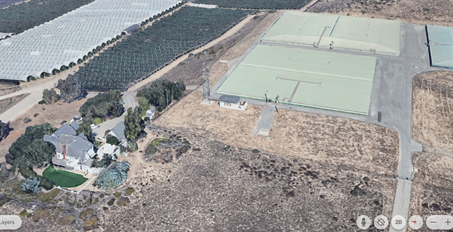
If you compare the length of the shadows from those three buildings with the little (guard?) shed to the left, you can tell they are really low to the ground like the roofs of underground tanks.
The city’s zoning map shows that parcel to be zoned “Public Facilities”. I can’t find any reference to what the facility might be, but a covered water supply reservoir would make sense.
For what it’s worth, here’s how they show up on Google Earth:
From the west
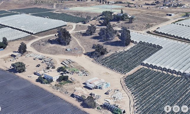
From the NW