You ninja’d me. I was going to do a long rant on the meaninglessness of continent as a word game that everybody gets to play. Everybody will probably thank you for getting me to skip it. I’ll only point out that islands confuddle the entire notion of continents. How far offshore can an island lay and still be part of a continent? There’s a sliding scale applied to Manhattan, Puerto Rico, and Hawaii. The first two are normally considered part of North America. The last is either part of Oceania or not part of a continent at all. Making every stray piece of land part of a continent called Oceania may be useful for a board game but serves no other practical or political purpose, nor is it recognized in all parts of the world.
Why must every overgrown volcano poking up above sea level be considered as part of a continent? Isn’t this just another game of lumpers and splitters?
My bad. I misread a cite as having the term apply to the small islands surrounding the UK, rather than small islands surrounding the island of Great Britain. A map shows a few small islands mostly off the west coast of Ireland. I assume they all indisputably belong to Ireland rather than the UK?
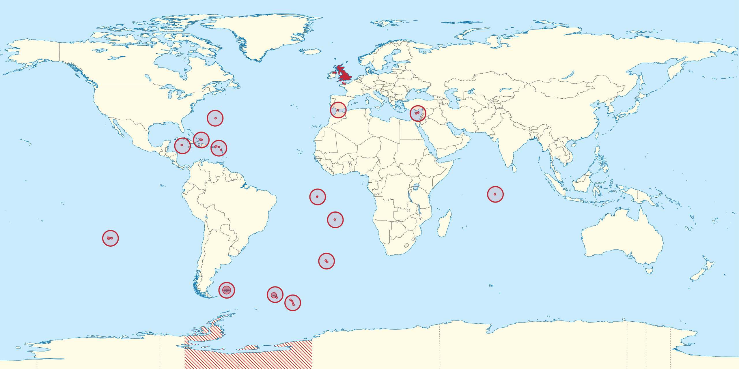
According to the map maker, France is in South America.
French Guiana’s people are French citizens, I believe, and they use the Euro, but I am still having a hard time with “France” being anywhere other than central Europe.
Continents are sometimes defined in terms of tectonic plates, which would open up the possibility of a “continent” that isn’t even islands, just entirely ocean with no land at all.
So if you really want to get away from those pesky French persons (as Monty Python memorably put it), you sort of need to decamp to Sakhalin Island or the Kamchatka peninsula. I may not agree that the French picked the very best places to be. But they did pick just about the very best places not to be.
Heck, even all of Antarctica is in the light-green proximity zone to France in all her globally distributed former glory.
It’d be fun to find a similar map for the UK & the USA and their various non-contiguous tidbits then compare all three. Not something I’m going to be chasing down though.
Tons of overseas territories and “crown dependencies,” as shown on this map from Wikipedia, including Bermuda, the Falkland Islands, Gibraltar, etc. But, it appears that they may not be considered to actually be a part of the UK.
As for the Pacific Plate (definitely not micro), one would be hard-stretched to imagine it is part of North America, so much as sliding along it. Anything in the middle of the ocean is definitely not near North America.
Yet French Guiana is part of France, no less than the Jura… they had a referendum, rejecting autonomy, as recently as 2010.
That disparity is an interesting point in its own right.
Hawaii is legally equivalent to e.g. Texas in its relationship to the USA as a whole. French Guiana is similarly as much a component of France as is Moselle. Of course both the USA & France have various other bits of land scattered about with more tenuous connections to the homeland legally speaking.
Besides the already-mentioned (and not controversy-free) Rockall, does the UK have any distant components that are legally equivalent to the subdivisions of their obvious homeland proper? Do any other countries have such?
Off top of my head, Japan has a few, of which Okinawa is one. But I think the inherently archipelagic countries like Japan, the Philippines, and Indonesia will of course muddy these categorical waters into murky impenetrability and might be better left out of the discussion.
I was thinking not only of the Irish Republic but also the Channel Islands and Isle of Man. Though the latter are Crown dependencies, they are self-governing for almost all purposes and definitely not part of the UK.
I get it. Greenland is a legal subdivision of the Kingdom of Denmark and is part of North America. Therefore…
Little can more perfectly encapsulate the scientifically head-exploding notion that continents can be defined by the flags of the nations who slaughtered indigenous peoples than this.
Continents are land masses. Political control over sections of the land and surrounding waters has shifted thousands of times over recorded history. At first, neighbors conquered contiguous lands. In the 1400s, European countries started establishing colonies in distant areas for exploitation. In the 1900s, colonies strived for independence, sometimes peacefully, sometimes not. In addition, older kingdoms broke down into individual countries, some of which divided further or merged back together. The process continues in all corners of the world. (There are only four, according to some people.) Physical maps seem to instantly obsolete.
It’s all semantics. As long as definitions are clearly laid out and agreed to, then France can be a South American country with a long Brazilian border. Without those definitions and proper context, continents are just land masses. How maps of them get colored don’t affect their individuality. They just cloud understanding rather than add to it.
I’m going to propose Ecuador (Galápagos), Spain (Canaries), the Netherlands (Bonaire, Saba and Statia) and Portugal (Azores and Madeira), to add to the previously mentioned USA (Hawaii and Alaska).
Editing to mention Chile (Easter Island is >3,000 km from the mainland).
There are no such distant parts of the UK (except maybe Rockall) - the most distal offshore islands (Shetland, St Kilda) are within a couple of 100 km of the mainland.
It’s fairly common in Ireland, although personally it doesn’t bother me at all, any more than the term “Irish Sea” bothers British people. Irish people tend to have a heightened sensitivity to terminology relating to the “British Isles” and its various subdivisions. You may not notice if someone says “Northern Ireland” or “the north of Ireland” but we do, and we tend to bristle if you refer to the Republic of Ireland as “Southern Ireland”. It’s all history; I’m sure we’ll get over it eventually!
As I understand it, there is a distinction between “continental islands” and “oceanic islands” depending on whether they lie on a continental shelf.
For me, the question of what continent Hawaii is in is nonsensical - it’s thousands of km from any continent. But it seems that for some purposes, every piece of land is considered to be allocated to one (and only one) continent. On the quiz site Jetpunk, there are endless arguments about the exact boundaries between continents, as if these were facts about the world rather than arbitrary divisions with no political significance.
Clearly using “Southern Ireland” is flat factually wrong as well as blatantly impolite. No doubt there.
Recognizing these sensitivities, what would be a good term to use within the Republic of Ireland or in conversation with folks from there when speaking of the northern part of the island of Ireland that’s currently a member of the UK?