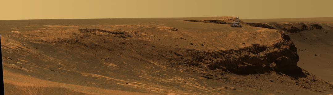
Recently NASA published a rather stunning photo of one of the current Mars rovers sitting upon a clif overlooking a crater. I was simply amazed at the fact that this Mars surveying craft was capable of taking a semi-distinct photo of the rover. All in all, very cool.
However, satellite images of the earth have left me just a touch unimpressed. I know that 1 meter resolution has been fairly widely available for the past decade and a half or more, but it doesn’t seem that this technology is improving dramatically. The highest available commercial resolution is around .6 meters for black and white; 2.44 meters for color.
Certainly impressive and allowing you to see a lot. However, Tom Clancy novels and other know-it-alls regarding military technology seem to widely proclaim that the US governement has spy-satellites capable of “reading a license plate” or some other fabulous claim. Essentially, we can track and identify individual people from space.
Although I’m not saying that such claims are utterly impossible, I sincerely doubt that military and intelligence technology is truly such orders of magnitue more capable than state of the art commerical hardware. A lot of people I’m sure would be willing to pay lots of money for resolution like that; how could the government possibly be able to lock that ability up completely from the private sector or other state entities?
Basically, although I’m sure exact answers are classified, how powerful are our spy satellites in reality?
Mars has less of an atmosphere to worry about, but I doubt that satellite intel can read a license plate on Earth, even if the plate is detached from the vehicle and pointing straight up at the passing satellite. I’ve read my share of Clancy and in one of his novels an identification is made of an individual. Bollocks, total and utter bollocks. The theoretical resolution of a camera bears little resemblance to that achievable in the real world.
The first thing that came to my mind is the movie “Enemy of the State” which had me thinking that it has to be true. I always believe that our government can do about anything, as they truly have unlimited resources.
I wonder if the advances in satelite resolution are based on zooming ability or on pixel number. Are they installing better lenses that can magnify the image more, or do they have the same zoom with a higher number of CCD cells? I wonder how much things like atmospheric interference and the need for greater exposure time factor into things. I can just imagine the ginormous flash blub needed without a longer exposure!
Also, it’s worth pointing out that the civilian satelites with the 1 meter resolution might not have been replaced because nobody sees the benefit to replacing them. Sure, maybe they CAN make a satelite that will be able to determine the weather by reading a newspaper over someone’s shoulder, but for most practical purposes, you have to ask yourself where the impetus for someone, especially a civilian company with a “Good Enough” satelite already up in space doing it’s job, to spend oodles of money on something that can do it so much better?
Oh, and jackdavinci, I just imagined the Hubble telescope with an old school bulb flash mounted on top of it. After that, I pictured some Russian officers about to oversee a secret satelite launch in the middle of the night, when all of a sudden, there is a bright flash.
Then a phone rings, and they answer to hear an American voice asking: “Did the flash go off?”
Also, satellites take a long time to design, build, test, and deploy. The technology that makes 1cm resolution feasible may exist, but the program to develop and deploy it may not be a top priority because of the excessive cost of building reliable high-precision space hardware. It’s hard work, and as long as contractors have to artificially compress their cost and schedule bids to get the job, programs will experience overruns.
After all that work and pain, satellites remain vulnerable to denial and deception because to a certain extent satellite orbits are always going to be predictable. A geostationary orbit is very very high, and no good for getting high-resolution imagery, so you need to rely on regular orbits like Molniya or polar orbits. Unmanned aerial vehicles (UAVs) fly much lower than satellites, so it’s much simpler to mount high-resolution cameras in their payload bays. The cameras don’t need to be radiation-hardened, the vibration requirements are less stringent (no need to survive a rocket ride), and they can be serviced inexpensively if something bends or breaks.
For the cost of one satellite, the USAF can put up a small fleet of UAVs with the same imagery capabilities, restricted only by the stealth of the UAV in question and the sophistication of the adversary’s air defense radars. For most countries of interest these days, that last variable is a big zero, so lots of money has gone into UAVs to complement our existing hard-working satellite constellation.
While no doubt a theoretical 1cm resolution is possible, I’d expect atmospheric refraction would render the practical resolution of such a device rather larger. Somewhere there’s going to be a point at which greater optical resolution is irrelevant. Modern spy satellites might already be at that point.