I can’t think of any major waterways near Los Angeles, California, USA.
WoW! That article reminded me of Michner’s “The Source”
What’s that really big body of water right there? Oh, yes, the Pacific Ocean. The biggest body of water
::Keith Olberman::
in the world
::/Keith Olbermann::
We’ve got a river that runs right through the city! ![]()
But yeah, I think we get most of our water from the Owens River (approx 200 mi away) or Sierra Nevada runoff.
Well, you get water from the Sierra East Side via the LA Aqueduct, from the Sierra West Side via the California Aqueduct, and from the Rocky Mountains, via the Colorado River Aqueduct.
El Pueblo de Nuestra Señora la Reina de los Angeles del Río de Porciúncula was originally started near the Rio de Porciuncula, what is now called the Los Angeles River. Water for the town was brought from the river via an aqueduct known as the Zanja Madre, which terminated in a brick reservoir in the middle of the plaza downtown.
Yeah, now I re-read the OP, it does mention oceans. I was thinking that we were looking for cities with no fresh water nearby. Scratch LA from the list.
mlai - when you see water in the LA River give me a call. I’ll come and take a photo. ![]()
A quick and dirty search of the history of Riyadh says the name is a variant of the plural of “garden,” and that it is on the site of several dry river beds. That’s in 3 or 4 sites, but I couldn’t find the “ur” source for it. One site also talks about a shallow aquifer, which I suppose could have been artesian at one time in history. I agree with the notion that no settlement would occur without a nearby source of fresh water, so I’d say that the natural source for Riyadh is either lost to legend, or the question is known to some Saudi academics, but they don’t think it so important as to load any documents on to the web. But I’d buy into the notion that it’s the world’s largest city not near a conventional source of fresh water for drinking, or salt water for transportation.
The question related to waterways, not water sources.
Anything underground would be excluded Id think?
Otara
Maybe this is a joke… but if not, apart from the Pacific (!), Los Angeles also has a number of rivers in close proximity - the San Gabriel and Los Angeles Rivers, with the Rio Hondo as a separate tributary - plus a handful of lakes. Apparently they had some serious problems with flooding in the early 20th century. It’s a pretty watery city. ![]()
Denver is not on any waterways. And its a heck of a lot futher from any ocean.
Every winter, people manage to fall in the rushing LA River and drown due to the large volume and swift currents.
In the summer, not so much.
Conan O’Brien just paddled some sort of pirogue (admittedly it may have had wheels on it) down the river a week or so ago, and it had at least a few inches to a foot or so of fairly swiftly moving water in it.
Denver is directly on the South Platte River. :smack:
I always thought it was Pretoria, South Africa.
Yes, but it’s a trickle for eight months of the year. Denver gets it’s water from man-made resevoirs in the mountains. The closest river of any size is probably the Missouri.
Which you can be excused for not considering a “waterway”. The classic description of the Platte is “A mile wide and an inch deep - too thin to plow, and too thick to drink.”.
Please re-read the OP.
This is not the first time this concept has to be fleshed out. The OP is asking about cities that aren’t near to waterways that can be used for irrigation or commerce or the like. “Ocean, lake, river or the like” it says. The South Platte River certainly meets these constraints.
And the reason it is a “trickle” for 8 months of the year now is that it is dammed upstream to provide drinking water, including the Chatfield Reservoir, which also was built to contain the river from flooding out Denver. Absent the reservoirs, the river would have water in it year-round, though obviously in higher amounts during spring and early summer, as the mountain snows melt.
yabob, while that description is very apt for the Platte River itself (formed after the junction of the North Platte and South Platte rivers, I’m not so certain it’s applicable upstream around Denver. And at least the Platte River valley offers a welcome alternative to typical Nebraska driving, since the valley is filled with pleasant views of the meandering river and its associated cottonwoods, enjoyable to watch as you cruise by them at 80 mph or so. ![]()
I dunno, I’d make the “water” restriction to be such that the city had to be navigable to by some sort of viable commercial vessels. Any old water hole will do for some local irrigation, and rules in too many cities, IMHO.
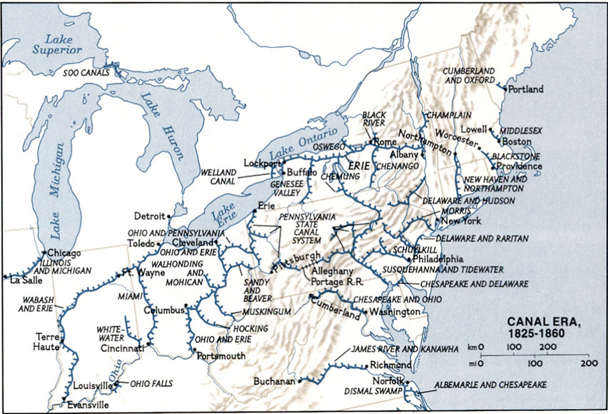
Granted, some cities which were once serviced by commercial ships no longer are able to be, with the closing up of various locks and the neglect of river dredging. I was surprised to learn that once one could sail from the Ohio river across the state of Ohio, and into Lake Erie, via a chain of streams, canals, and locks. But no more.
But that’s my bias, and I’m a bit of a geography geek, so my biases may be a bit quirky.
Good grief! One used to be able to sail from Columbus, OH to Terre Haute, IN either via the Ohio river or Lake Erie! http://www.latinamericanstudies.org/19-century/us-canals.jpg
The various major Ohio canals were very important to the development of the state, part of why it was such a powerhouse by the time of the Civil War.
I used to walk regularly along a path topping an old levee for the Miami and Erie Canal, part of the extensive system that came to be known as the Wabash and Erie Canal. There was another such canal system on the eastern side of the state, from Cleveland to the Ohio River, if I’m not mistaken.