When did sailing across the sea become relatively safe?

In The Surgeon’s Mate, first published in 1617, James Woodall wrote of several remedies and treatments for scurvy that included lemon juice as a daily preventative, he mentioned certain grasses you could boil and drink the tea of to help, and then there was wine which may have had higher levels of vitamin C back in the day than it does today (not enough really though). By 1750, I think it was the policy of the British Royal Navy to require sailors to drink the juices of lemons, lines, or tamarinds to stave off scurvy.

I’m not sure how early it was before someone connected diet to scurvy, but it sure took a while before diet became a common preventative measure.

The idea of a “vitamin”– a trace but indispensable substance contained in some foods, and the related concept of a “deficiency disease”– didn’t really get established until the latter 19th century. It required chemistry to be advanced to the point of being able to isolate and identify the specific chemicals in question; plus, controlled experiments that could show that deficiency diseases were caused and cured by a very narrow binary presence/absence of certain factors. Before that people had vague ideas of general “healthiness”.

Not knowing and being able to test for the ascorbic factor meant that observations tended to be inconsistent or contradictory. For example fresh citrus juice worked against scurvy, but often not the heavily processed stuff sailors got. People with regular access to fresh meat didn’t get scurvy, which seemed to disprove that there was anything special about fruit and vegetables.

Right; it wasn’t until 1930 that the link was scientifically proven by Hungarian researcher Albert Szent-Györgyi.

It depends somewhat on the type of ship and sails you have. A ship with square-rig sails can’t tack upwind as well as a sloop or schooner with fore-and-aft sails.

They can’t sail as close to the wind for sure, but if we’re talking prevailing winds, they can do it well enough to go against them easily enough.

I sort of doubt that if someone was sailing from New York to London in 1810, that they’d sail all the way down to the Trade Winds in order to sail eastward. They’d just tack in pretty huge tacks and take longer.

I sailed on a barque from Nova Scotia to Grenada, which is almost due south. Rather than go in a straight line, apparently it was faster to sail southeast in the prevailing westerlies, then turn southwest when we got to the trade winds.

So yeah, sailing ships can plot a course to take advantage of prevailing winds at different latitudes.

Absolutely, but I’m not so sure that when you want to go 3150 nautical miles to the ENE, it’s better to sail 800 miles due south just to catch the trade winds, and then work yourself 800 miles north again.

Edit: A bit of googling says that the Gulf Stream current was a much bigger deal than the prevailing winds were- apparently the eastbound route was further north than you’d think, in order to take advantage of it. And similarly, the westbound route was further south as well.

Here’s an excerpt from a naval history board post that explains it:

WEST-BOUND ROUTES
By far the principal “all season” west-bound route from NW European ports to the Atlantic coast of North America was the “Southern Route” via the English Channel, then SW past the Azores. At about 20degN latitude the route turned W, ultimately veering to the NW or northerly, depending upon which port in the Savannah-Halifax range was the intended destination.

There were two other routes available. In the months of autumn, a “Northern Route” became a possible option, whereby ships would pass to the west of the British Isles, heading for a position approximately 55degN lat / 30degW long, then heading WSW for the Quebex-Halifax range of ports. On rare occasions, it was actually possible to make almost a direct voyage from the SW tip of Ireland to Boston or Newport. Ships following this rare route, but headed for ports in the New York-Baltimore range would veer to the SW about mid-ocean, pass near Bermuda, then approach destination from the SE in order to avoid fighting the powerful Gulf Stream.

EAST-BOUND ROUTES
The route back to Europe followed the ENE flow of the Gulf Stream up the North American coast past Halifax and St John’s, then across the North Atlantic to a landfall off Cornwall or the SW tip of Ireland. Ships tended to make a slightly more southerly crossing in spring and summer in order to avoid the very dangerous threat of icebergs.

EAST BOUND TRANSIT TIMES
“Ocean Passages for the World - Third Edition 1973” (which cites sailing records of Messrs Hardie and Company of Glasgow, Scotland) mentions typical passage times from New York to the English Channel “for a well-found sailing vessel of about 2000 tons” as approximately 25 to 30 days, with ships logging 100-150 miles per day on average. Judging from the size of ship described, these data probably refer to mid 19th C to early 20th C. “Harbors & High Seas” by Dean King & John B Hattendorf (which cites “Square Riggers on Schedule”, Princeton Univ Press, 1938) gives the following New York to Liverpool passage times for North Atlantic sailing packets in the period 1818-1832 as follows: fastest crossing - 21 days; slowest crossing -29 days. With an average distance of approx 3,000 miles, this equates to a range of about 100 to 140 miles per day, or an average speed over the ground of about 4 to 6 knots.
One plant I’ve encountered on the seashore in the UK is Scurvy-grass; it isn’t a grass, but a brassica. The antiscorbutic properties of this plant have been known for hundreds, perhaps thousands of years.

Bad storms could be a hazard yes. The biggest problem they posed for sailing ships was that beyond a certain point stronger winds stressed the ship but didn’t add any further propulsive power. The sails, spars, masts and rigging could only take so much force before the sails had to be reefed or taken down entirely to not literally get carried away. Meanwhile even tail winds at storm levels could swamp the ship while head winds could bodily push the ship leeward in spite of everything the sails could do.

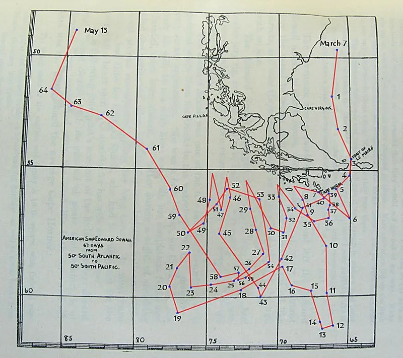
At Cape Horn this was complicated by the fact that you could only tack so far north or south before running into either Tiera Del Fuego or the Antarctic ice bergs; and due west was against both the wind AND the ocean currents.

ETA: here is a plot of the windjammer Edward Sewall, captained by the ironically named Captain Richard Quick, in it’s passage westward in 1914. As related in the Time-Life book The Windjammers,
“Quick was twice blasted back to positions that he had passed weeks earlier; in th end he logged more than 5,000 miles to complete what in better weather what would have been only a 1,500 mile voyage”.

I hope no one fell overboard!

In those seas, an automatic death sentence. There would have been nothing anyone could even try to do.