At sunset yesterday, I was watching a beautiful “mackeral sky”- a sky filled with a regular pattern of clouds-rows of cloud that looked the the bars of a mackeral’s sides. Why do these patterns happen this way? When this formation occurs, are the distances between the clouds/widths of the bars according to a regular pattern?
It’s probably due to the turbulence of the air they’re forming in. Air is a lot like water in the way it acts. If you imagine a river with some rapids caused by obstacles below the surface, the rapids can sometimes form very regular wave patterns. The same thing can happen with air and clouds.
I believe the spacing is due to the size of the convection cells that produce the cloud. As for what controls the size of the convection cells… someone else will have to help there.
Another cause of regular cloud patterns can be lee waves - standing waves formed as winds pass over high ground. They are found, as the name suggests, in the lee of the high ground. Here’s a satellite pic.
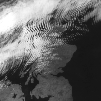
Kelvin-Helmholtz wave clouds - not necessarily the only phenomenon at work, but easy to see how something like this could settle out to a mackerel-striped pattern of barred clouds.
Thanks! It is clearly a wave phenomenon- the clouds look a lot like the ripples you see on a sandbar, in the ocean.
Clouds follow the patterns in the air. Different globs of air will come off the earth and merge into the flow. This is like adding cream to coffee. And once a cross breeze stirs things, the globs become swirls or streaks of differing temperature and moisture content.
Sailplane pilots often seek them out. The current distance record is just over 3000km (!) in wave lift generated by the Andes mountain chain.
Were they really a “regular” pattern or did you human brain just see it that way?
I don’t think the OP is talking about “patterns” in that way (like seeing a “face” in the clouds or somesuch).
I doesn’t take any special brainpower to see that there can be regular patterns in cloud formations (stripes, bars, etc…). See examples below:
http://www.flickr.com/photos/41188800@N00/151161437/
http://www.flickr.com/photos/pandarine/5935589/
http://www.flickr.com/photos/pandarine/5971964/

Another possibility: gravity waves. As I (roughly) understand it, the atmosphere shakes up and down, with gravity as the driving force. At the top, this leaves bands of high pressure (the crests of the waves) and low pressure (the troughs). Water vapor condenses in the low-pressure bands to form clouds.