According to wikipedia, there is some disagreement as to the source of the River Thames. This may be a silly question, but why the disagreement? Shouldn’t someone be able to simply follow the river up to the source? I’m obviously missing a critical part of the story here ![]()
Rivers don’t just have one source - some tributary streams may not even be there from one year to the next.
It’s not just the Thames. The source of the Mississippi River is considered to be Lake Itasca in Minnesota. But the lake is fed by small streams. Should one of those be considered the source?
For that matter, more water flows into the Lower Mississippi River from the Ohio River than the Upper Mississippi and Missouri Rivers. So technically, shouldn’t the “Mississippi River” be considered to start at Pittsburgh and then turn south at Cairo, Illinois?
The Sacramento River was traditionally thought to rise near Mt. Shasta. But if you actually track the source waters, they can be traced much farther to the north and east.
Follow the river upstream. You come to a point where there’s a branch: Two rivers come together. Which branch do you take? Or do you call that branch the origin of the river, and give the two tributaries each a new name? Ultimately, it’s arbitrary, but there might be money or politics riding on the decision.
For another example here in our own country: Three rivers, the Gallatin, the Jefferson, and the Madison, come together to form the Missouri River. So far, everyone agrees on that (though we could just as well have agreed to call the Jefferson the continuation of the Missouri). Except that the three don’t all come together quite at the same point: The Jefferson and the Madison come together first, and then about a mile downstream the Gallatin joins them. Does the Missouri start at the Jefferson-Madison junction, or does it not start until the Gallatin joins? The federal government and the state of Montana disagree, and it determines which of them is responsible for upkeep of the parklands along that mile.
Or, for that matter, since we’re speaking of the Missouri: If you follow the Mississippi upstream to the site of St. Louis, you find the confluence of two rivers. Which one do you call the continuation of the Mississippi, and which one the tributary? Do you pick the one that provides more water? The one with the larger cross-sectional area at the junction? The one that extends a further distance upstream? No, you do not. You pick the one that grants the more territory to a nation who’s claiming all of the land west of the Mississippi River.
or the Ohio flows to the Gulf.
either would mess up the nice boundary.
The Ohio “begins” at the confluence of the Allegheny River and the Monongahela River, so one of them (or the Ohio) does not really exist, while another is just carrying the wrong name.
As noted, above, rivers are just channels with water flowing in them* and the names given to which channel is often based on human caprice. There is some attempt at logic, based on flow, importance to trade or borders, etc., but a lot of chosen identifiers can be challenged, (and many are). The notion that “a river” is some sort of objectively real thing is one that we should try to eliminate in elementary school geography class, as it causes a fair amount of confusion.
- Well, the Platte, the Powder, and a few others are slight depressions in the ground with water running over them.
If you follow the “largest average volume at all junctions” criteria, the Allegheny is misnamed, and the Mississippi, or the Ohio, if you prefer, begins at a spring in Potter County in Northern PA. Under that criteria, the Missouri gets left alone, as the whatever-you-call-it is the largest volume at that junction, by quite a lot (the Ohio alone, upstream in Cairo is 3 times the volume of the Missouri).
OTOH, at the junction forming the Ohio in Pittsburgh, neither one is"obviously" the tributary, although you find out that the Allegheny is actually about 60% of the volume when you measure them. That makes considering each fork a separate river a reasonable solution. Somewhat more appealing than having a “North” and “South” fork of the Ohio, IMO.
Once they discover the source, let the good Thames roll.
The Seine river shouldn’t be the Seine, but the Yonne, a “tributary” which has a larger flow than the Seine when they meet.
ETA : what was considered the main river was established long ago, hence determining which river is the largest wasn’t accurate. The source of Seine was already identified (mistakenly as written above) during the Celtic era.
I’m confused. How can it ever be simple ? Rivers have catchments… water sheds.
These are areas … there is no following a line anywhere …
Even when you can find a river’s highest area, sometimes you can find its a swamp or lake with multiple outlets and you are then wondering if s one thing can be the “head” of two rivers ? or what ?
Thank you. I lived in St Louis for 20 years and always wondered why the comparitively minor Mississippi carried the name further upstream. Just never bothered to look it up.
Mind you, I’m not certain that’s the correct explanation, either. It’s just the best explanation I’ve come across.
I feel like one of the Highlander sequels should deal with this issue.
So, in other words, those people with poor geographical judgment were in Seine?
There really can be only one.
Rivers are not “NOT gates”. They can have multiple origins.
It turns out that that was not why the Mississippi channel was determined. The real reason is that the first European explorers of the river (the Joliet-Marquette expedition) started from much further north than the confluences with the Ohio or Missouri. That expedition met the Mississippi at the confluence with the Wisconsin River and went down to the Arkansas River. Naturally, they assumed that any rivers joining the river they were on were tributaries.
If the river had been explored from the other direction, possibly the naming would have been different.
Why is that natural? If I’m going down a river, and I meet a significantly larger river, I’m going to say that the river I was on is a tributary.
Would it be obvious to a couple guys in a canoe (with no measuring devices), that the Ohio or MIssouri are significantly larger?
At any rate, the idea of maximizing the area to the west of the river is bogus. France originally claimed the entire drainage area of the Mississippi in 1682 (the La Salle expedition). The split between the areas east and west of the river didn’t happen until 1763, when, as a result of the Seven Years’ War (French and Indian War), the area east was ceeded to Britain and that west to Spain. By that time, the names of the rivers had been well established.
Right. The rivers were named well before their roles as a territorial division became significant.
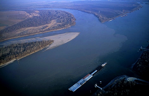
At the confluence of the Mississippi and Missouri, the Mississippi is much wider, a fact that would easily be evident from a canoe. See also here, with the Missouri entering from the upper left.
The Ohio and Mississippi are more similar in size at their confluence, although the Ohio is pretty clearly somewhat larger. Also here.