You do know there’s no land in the middle of the Arctic? It’s all floating sea ice. Only the land perimeter of the Arctic sea overlaps with Antarctica.
The wiki article
has better globe-shaped views than the antipodal map site a few posts ago.
The punchline being that a relatively small fraction of Antarctica is antipodal to any land. The North Slope of Alaska, some of northern Canada, much of Greenland and a smidgen of Siberia is about it. Plus some islands north of Siberia.
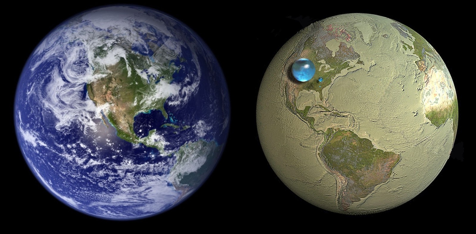
Like the atmosphere, the water is a very very thin boundary layer over what’s almost entirely a rockball surrounding an ironball.
How thin? 1 part per 2000. So about 0.0005 = five ten-thousandths. The atmosphere is a little thicker at about 0.0125 or 125 ten-thousandths. Put together its 0.0130 or a bit over 1%.
The only use of the other 98.7% to us is to generate enough gravity & magnetism to keep the 1.3% we care about stuck to the rock & not drifting off into space.
Kinda scary when you look at it that way. Good thing we’re doing our damnedness to keep that thin layer pristine and viable for the long term. Oh … wait. Shucks!
Okay, this one is embarrassing because it’s local geography.
You can go to the beach park in Olcott, NY (it’s a very nice location and I recommend it) and look out over Lake Ontario. And on a clear day, you can see the CN Tower in Toronto in the distance.
Based on this, I had just assumed that Olcott was pretty much straight south of Toronto. I’ve driven to Toronto on several occasions. I know you drive west to the end of Lake Ontario and then back east to Toronto. But I really hadn’t thought of the north/south line because it’s all water.
So I was surprised when I happened to be looking at a map the other day and discovered that Toronto is not due north of Olcott. It’s not even due north of New York state. If you went straight south from the middle of Toronto, you’d end up somewhere west of St. Catherines. Which, just to confuse things further, was named after a single Catherine who wasn’t a saint.
At this point, I won’t even guess why the international border between the United States and Canada goes in a northwestern direction through Lake Ontario, instead of straight north.
As a general principal you’ll note that when a river forms a border and the river empties into a lake (or ocean), they extend the border line along the axis of the last stretch of river straight out into the lake until that line collides with one drawn more or less down the centerline of the lake. Or at least the centerline of a simplified schematic of the lake.
e.g. Lake Ontario is simplified into a sausage with a kink at each end, then the 3 long straight line segments are drawn to divide the lake. Then they extend lines straight out from the border rivers’ mouths and wherever they join the 3 main segments is where the boundary is settled.
There’s exceptions galore, especially if there was horse trading about putting certain towns on one side or the other or where the total volume of water, shoreline, etc. would be grossly disproportionate if they just followed the simple science. It’s like gerrymandering, but gentlemanly gerrymandering, not the current at-daggers-drawn kind.
That may be the general rule but it didn’t happen here. The border runs along the Niagara River into Lake Ontario. The last bit of the border in the Niagara River is a straight line. But then there’s a bend in the line as it enters Lake Ontario and the border goes in a different direction than the one it was on in the river. So the lake border line is not a straight extension of the river border line.
If they were bending the border line at that point anyway, there was nothing that prevented them from bending it to straight north rather than northwest.
Overall, the border follows the principle you describe as it passes through the Great Lakes. The border is a series of straight lines that appear to have been located so they are approximately equidistant from the Canadian and American shores. With this one exception, where the line is angled so it is closer to Canada than America.
The US-Canada border was defined as the waterway through the Great Lakes system, and therefore the border went where the water went. Years later, treaties were entered into defining territorial limits within those bodies of water.
I’d suggest that they are lines on a map that were drawn in the way LSL Guy suggested. Really, they don’t mean much, unless there is a shipwreck or some other reason to claim jurisdiction over whatever happened. If a Canadian vessel in Lake Ontario strays into US waters, as depicted on the navigational chart, but never makes landfall in the US, does it count?
I recall the time my buddy and I set out on his sloop, out of Toronto bound for Niagara-on-the-Lake, Ontario. He had a nice boat, 26’ long, and equipped with a small kitchen and a head; and of course, we had filed a float plan and had all necessary safety gear: PFDs, VHF radio, radar reflector, and so on. We were only good navigators, not great ones, and I’m sure that we strayed into American waters a few times, coming and going. But the US Coast Guard was not alerted, we got into and out of Niagara-on-the-Lake safely, and we never made landfall in the US, in spite of sailing through American waters.
In defense of the adults, they never said the hole had to be a straight line that intersects with the center of the Earth. The hole could have been something like this:
Not by much if it does. The molten core extends from roughly 1220 to 3485 km from the center, or about halfway to the surface. But now we’re getting into geological misconceptions.
And at really weird connections, Wendy Carlos (of Switched on Bach fame) has a whole webpage of map descriptions, including antipodes. One of her other hobbies are solar eclipses.
Here’s a good UK geography fact. It turns out that Leeds (which is pretty much in the middle of the country in turns of east-west) is slightly further east than Newcastle-Upon-Tyne (which is on the east coast).