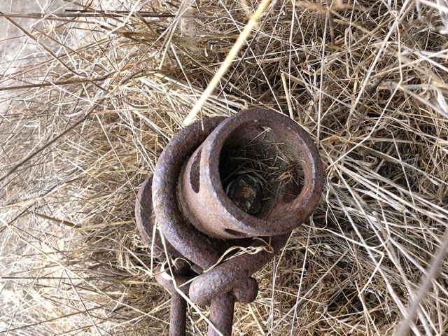
I was hiking in Los Flores Ranch Park (California) and came across this thing:
(Sorry, the pic is rotated left)
Anyway the pipe is about 5 or 6 inches in diameter and about 16 to 25 inches long.
The iron rods merge about 2 or 3 feet away into a turnbuckle thing and another rod ran further back about 10 feet until it disappeared into the hillside. (I found this on a fairly steep grade).
It was out in the middle of nowhere and I didn’t see any other relics nearby.
I think the area has a history of oil and farming.
I don’t have any other pictures and I won’t be going back anytime soon. (8 mile hike).
Probably an anchor for a block & tackle arrangement. So a hefty pulley of some sort would be shackled into the holes at the top of the pipe. The a rope or metal cable is passed through the pulley. The predominant load would be upwards as shown in this pic, whichever direction that is on your hillside.
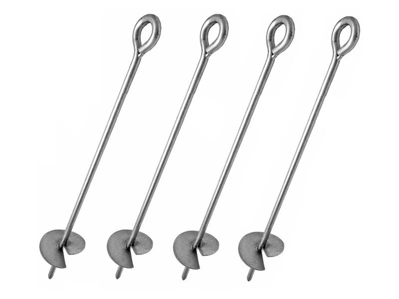
Akin to this, but raised off the ground by the height of the pipe.:
I bet if you excavated where the rod disappears into the hillside you’d find either a large screw (like a giant corkscrew) or a flat plate toggled to the end of the rod. So Olde Tymey larger versions of these things:
There may have been something like a mine entrance 10 or 20 feet downslope. Which nowadays might look like nearly nothing. Or, since it’s in a park, it may have been carefully filled and hidden by the park authorities long enough ago that there’s nothing to see. Ground penetrating radar might find the disturbed area but your eyes won’t.
Google Earth has some pretty darn good hi-res pix of that park. You might try looking for any unnatural looking patterns in the dirt or plant life near where you know the site to be.
Growing up in SoCal I really miss that terrain. So pretty.
Starting from your pin …
300 ft south up on the flat top there’s faint evidence of a former building or two. Both rectangular and oriented long axis SE-NW.
The striated terrain about 100 ft downslope to the NW of the pin is interesting, but is probably just drainage effects from where the slope flattens out. The small subsidence defect in the hillside about 600’ further NNW is highly suggestive of mining and water capture in old underground earthworks; there are no similar formations within a mile I could find. It’s not in a kettle, it’s still on the slope.
If you ever go back there, poking around that subsidence & downslope from it for 30-40 feet might find you some artifacts.
Streetview from US101 doesn’t reveal anything noteworthy.
There is nothing there on the aerial photos that go back to 1981. The topos from 1947 and 1950 show 4 round objects almost touching, They appear to be the same as a present day round object 2380’ to the south east which has also been there at least since 1947. Looks like an oil tank. Dennis
I live and do a lot of hikes on the central coast and there are a ton of relics in the area from the bad old “There Will Be Blood” oil days. I haven’t seen anything precisely like the thing in your pic, but it does have that oil drilling junk vibe about it.
In the location bar you can use addresses, city names, zip codes, coordinates, etc. The more specific the better. If you copy Google coordinates you have to add a (space) after the comma for the first coordinate to make it work properly. Once there you can select aerial photos and topographical maps for various years. The photos do have watermarks that often obscure what you are looking for! All of this and additional years is available without watermarks on the USGS site but it is much harder to use. I can write a user guide if anyone wants one. Dennis