Any good draughtsmen who want to do unpaid work out of the goodness of their hearts?

I’m in the planning stages of a roleplaying scenario that’s going to be a long, epic, good old-fashioned quest, with dungeons and monsters and magic items and monsters and riddles and monsters and treasure and monsters and a Dark Lord and saving the world in the end. The whole kit and kaboodle, complete with wistful nostalgia for the playful days of yore when “roleplaying” meant “killing monsters underground”.

My players are going to need a map of the lands they traverse seeking the items of power they need to complete the quest. I could just draw them a functional map and order them to enjoy it, but I would like it to be pretty. So I was hoping that I could draw an aesthetically unpleasing but technically accurate map, either scan it or send a copy off in the mail, and have a skilled and altruistic as well as extraordinarily intelligent and physically attractive (is it a waste of time to suck up to an as yet unknown person?) Doper draw a pretty, fantasy-style map of the area. You know, an area of mountains denoted by little mountains, a city denoted by a little drawing of the city or a famous building therein, an area infested with sea monsters denoted by a sea serpent rolling in the waves. That kind of map.

My standards aren’t all that high; I’d just like it to be better than the five-year-old-level map I could produce. I know there are a bunch of talented people here, I’m sure we have a couple of draughtsmen who feel for a poor gamesmaster and have too much time on their hands.

The size of the map is standard A4, and shouldn’t be too much work to reproduce.

Also, in case I get several takers, do any of you mind if I send it off to more than one person?

You can try sending it off to me. I can’t promise anything for a bit, but I can give it a try. While I do make maps, I don’t make those kinds of maps. I might like a bit of a challenge. You can either email or PM me.

Great. I’m planning to finish it tomorrow and will get back to you when it’s done. I’m not sure at all that I can manage to scan it; where in the world is “Somewhere in time”?

It’s right between Powerslave and Seventh Son of a Seventh Son.

Actually, between Superman and Superman II.

Why not scan your map in, post it online, and let all takers post their “replies”? I’d love to take a stab at it, too. I’ve done a few fantastical maps in my day, including a great map of New England for a Phish fan who was following the band for their northeastern tour dates. It’d be a blast!

If I can get it scanned, I’d love to do this.

My version of the map is completed. I’m lacking a crucial cable for the scanner, so I’m going to give the original to a friend and have him scan it. With luck, it’ll be up tomorrow.

I’ve written some notes on the locations on the map, to give you an idea of what they’re like. I’ll post them when the image goes up.

:stuck_out_tongue: Between “Ashokan Farewell” and “I’ll Love You Forever”.

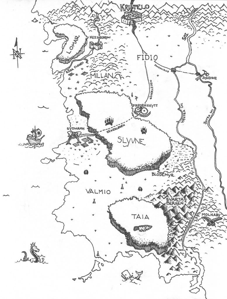
The scan is up. The link should take you to the fullsize version but I’m not entirely sure if it works. The scan came out a bit faint, but it should be usable.

Here’s some stuff on the various locations on the map. Feel free to use it or ignore it, but please don’t directly contradict it. I’m including it mainly to set the mood for each place.

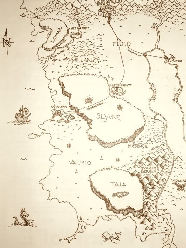
To the north, beyond the map’s edge is the “civilized” area of my setting. The area portrayed by the map is a much more wild and free place, with few cities, few roads, and plenty of nomads, roaming bandits, and the like. The impenetrable northern mountains form a natural boundary.

The scale of the map, if it matters, is about 1 cm = 50 km, which translates to Merkin as 1 inch = 200 miles.

No legend should be necessary. The spiky bits are mountains, the round bits are hills, the cloudy bits are forests, the lines are rivers, the broken lines are roads, the black dots are cities, and the collection of short lines is a swamp.

LOMAR: The kind of lush, green forest you imagine elves and kind faeries to hang around in.

RÖDA FLODEN: A slow-running, wide river flowing down from the mountains. Bridged at one point only (see KEJSARBRON).

KEJSARBRON: A heavily fortified bridge built in ancient times. Abandoned these days, as far as the mapmaker knew.

KRISTELO: This city is a “gateway to the South” type place, where all travellers to the South gather before continuing on their way. It contains everything from majestic palaces to mud huts. All trade routes pass through Kristelo, so basically anything you look for can be found here.

MILLAN: This is an area of gently rolling hills mainly inhabited by farmers.

FIDIO and VALMIO: Two flat plains separated by the forest of Slyvne and the marshlands of Blodemyr. Inhabited by nomadic tribes of herdsmen.

BLODEMYR: A tract of marshlands blending into the river of Västra Soi. Some of it is merely damp ground, other places are basically small lakes broken by islands.

SÖDERLEDEN: The main road in the Southern lands, connecting the three major cities and forming a way from the sea to the North.

JONDSOIRUD: A younger road than Söderleden and built with far more haste. In places, barely more than a strip of flattened grass.

SOI, VÄSTRA SOI, ÖSTRA SOI: A wide, wild, raging river forking into two. Long thought uncrossable. Västra Soi was finally bridged, and then things happened very quickly. Jondsoirud was constructed, Östra Soi bridged, and the city of Jondsoi built.

JONDSOI: A young, pioneer, frontier-style city. Many people running from an unsavory past end up here, where your past deeds are much less important than your willingness and ability to work hard.

NONDELOSOI: A wasteland with little in the way of life or natural resources. The occasional band of thugs, mainly people exiled from the lands west of the Soi, can be encountered here.

FREDENSKYTT: Your basic, run-of-the-mill fantasy city. Go nuts.

SLYVNE: A deep, dark, untamed, dangerous forest. Feel free to put in wolves, bears, woodwoses and assorted monsters.

SYDHAMN: The only large seaport of the Southern lands. A city built almost entirely to support the harbour. Lives off fishing and trade.

SVARTA BERGEN: An unexplored chain of mountains, often obscured by blackish fog. Contains volcanoes.

TAIA: A forest rumoured to be inhabited by wildmen. Little else is known about it.

MOLNABY: This city floats about five hundred meters above the ground and is inhabited by a tribe of winged people. Don’t make this too obvious; it’s supposed to be a surprise for the players when they get there.

THE SEA: I’d appreciate a few extra things off the coast, like sea monsters, mermaids or a ship or two.

Anyone who does me this favour: thanks very much in advance. Don’t worry about replicating my map exactly; the tiny details don’t matter much as long as the big things are the same. No need to painstakingly copy the coastline, for example. The players’ map isn’t supposed to be 100% accurate anyway.

EDIT: Jurph and Edward the Head, I realize I’m the one getting the favour for nothing here, but if you decide not to do this or don’t have the time, or it’s just going to take a while, please let me know so I don’t wait for you to reply. Thanks a lot.

I’ll see what I can do. I will try and get it done by next week if I can. It might not even that that long. The thing is I make aeronautical charts which are a bit different. I think the mountains will be the odd part for me.

eta: What format would you like it in? I can probably email you a jpeg if that’s ok.

Jpeg will be fine. Thanks!

I’ve got a ton of homework this week but I’m mostly finished with the hard stuff, so I should have a little time this weekend to throw at it.

You mention that the players’ map doesn’t need to be 100% accurate; can you mention how the players came to have it, and what sort of NPC drew it? For example, if it’s a trader’s map it will give prominence to cities with an economy; an artist’s map would be commissioned by a noble and might give undue prominence to a city near the center of the map (which turns out not to be as central or as prominent as depicted) – no prizes for guessing where the noble is from. Also, does the campaign take place in a world with compasses or knowledge of the cardinal directions? Obviously VASTRA and OSTRA are “west” and “east”; I would leave off the compass rose unless this was a chart drawn in a port city, where navigation would be well-known. I was thinking of just the letter “N” and a very basic compass rose unless the map was drawn for a navigator or noble.

One last stylistic question. I was thinking of placing representative icons behind the names of the few major cities you’ve listed – crossed feathers (are they quills?) behind Molnaby, a fish behind Sydhamn, crossed tools behind Jondsoi, a palace in Kristelo. What’s an appropriate distinction for Fredenskytt?

One of the players is a wizard of the sort that spends a lot of time hanging around in libraries, and a librarian got hold of it and thought he might be interested. Maps of the entire Southern lands are quite rare at this point in time. As to what NPC drew it… haven’t decided yet. As far as the campaign goes it could be anybody, so draw it the way you feel like! It’s definitely a Northerner, though, not a person with an affiliation for a particular city or so.

They do have compasses and educated people, sailors (and mapmakers) and so forth are familiar with the cardinal directions.

Anything from an elaborate compass rose to a cross with N on top is fine. It’s OK to leave it off too; whatever you think looks nice.

Wonderful idea. This is why I turn to artists (well, this, and the fact that I can’t draw). Fredenskytt has good artisans - smiths, jewellers, potmakers, clockmakers - so perhaps an anvil, gears or the like?

Here is my draft - that’s a photograph of it, not a scan, and I used Picasa’s sepia feature to make it look more like parchment. I still need to erase some pencil markings (like on the Eastern Soi river) and add some shading to the forests, but you should have a final copy before the end of the weekend. If I’ve completely missed the boat on something let me know, and I’ll scan it, digitally white out what I messed up, and re-draw that portion.

I completely missed this thread.

Let me know if you don’t mind me taking a stab at it this late. I need to practice more and I need to have some fantasy art made for my portfolio.

The best map I ever used on an extended campaign was a detailed topo map of an area near my hometown. You can easily buy them both online and in stores, and you can even download them from several sites. Get two (or more) copies, and mark them up as desired.

I mutilated a copy for the players, burning holes, folding to pieces, staining, writing cryptic notes, etc. Then I tore it into several pieces, so that they had a concrete goal – find the center piece of the map!

Topo maps have great notations that you can use to flesh out your campaign, roads and trails are marked, houses and settled areas are detailed, and everything has a name – a big plus for managing a large campaign.

You can also find tunnel and other specialty maps for underground use – my players have explored several caverns, including Mammoth cave.

Very sorry for not responding until now; no clue how I managed to miss the updates to the thread.

Jurph, absolutely gorgeous. You’ve hit it out of the park, if that’s the correct vernacular. I particularly love the little waterfall where Röda Floden originates.

I have a few things to mention, none of which are very important, so feel no pressure to fix them; you’ve done quite enough as it is. I would like the word Söderleden somewhere along the road between Kristelo and Fredenskytt, just to accentuate that it’s not just the bit between Fredenskytt and Sydhamn that’s called that. If possible, I would like the road going north from Kristelo to be visible. Finally, I’d like the hills around Molnaby to be a bit more pronounced, like the ones at Millan. Like I said, these are just little things.

One aside: the photo is missing a little bit to the right, right? The name Molnaby is incomplete.

GIGObuster, you’re very welcome to give it a shot. If nothing else, I’m sure a second map can come in handy; as they’re so rare in the campaign the mere existence of a second complete one could be a plot device. By the way, if you need fantasy art for your portfolio I may have some other needs, if you’d be interested.

Again, sorry that I haven’t responded until now, and thanks very much for the work and interest.

Alright, my final version is posted, and I’ve e-mailed the high-resolution original scan to Priceguy.