I just learned something new. It turns out that at least some publishers have cartographers on staff who draw up maps of fictional places.
Cool! I belong to that class of persons who has drawn a map to accompany my fantasy novel, but, by gum, I did 'er myself!
(Here is a link…this is a kind of test, as it’s my first use of Imgur.)
I’ve long been a huge fan of the late Karen Wynn Fonstad, who actually had some success with authoring companion atlases for a number of 80s-contemporary fantasy series.
Maps in the front or the back of a book are often my favorite part. A hard to read map is usually the only reason I am disappointed when I get a book on my Kindle vs. a hard copy.
Yes, her Atlas of Middle-Earth is a key item in my LotR collection… that was one of my better yard-sale finds.
I helped my brother make a map of 'Salem’s Lot when he was in high school. There were discrepancies (King’s fault).
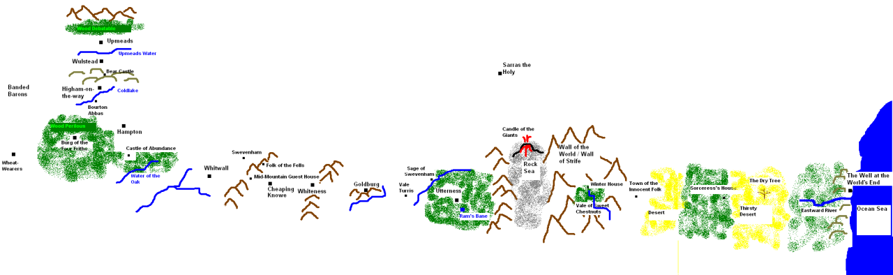
A few weeks ago, I was reading “The Well at the World’s End” and I was wondering if someone made a map for it (so I could check my understanding against someone else’s).
Fortunately, someone had made one. (A pretty crude one, but a map nonethless.)
Do they really have people “on staff” to do it? IIRC, several authors have drawn their own maps (John Myers Myers, Lin Carter). If they need someone to draw one from scratch, or to pretty up one already sketched by the author (Robert E. Howard, f’r instance), I’d think they would simply hire someone for the task.
Popular as fantasy novels are, I can’t see them keeping someone on full time to do this, and only this.
A few years ago Scottish author Margaret Elphinstone wrote a book called Hy Brasil about present day life on a fictitious mid-Atlantic island. Before publication she gave her publishers a map of the island. They reproduced it so poorly it was difficult to see the details easily.
Eventually she put up her own map of it on her own site.
Much better!
Long ago I read a really interesting article about how to make a believable map without needing to really have any skill at it.
The idea was to take an actual map of some real Earth area – NOT an entire continent or even a specific country, but maybe a chunk from several adjacent countries or the map of a lesser unit, like a province or county or random island… Change the scale as necessary to fit your story (i.e. Do you want a map of a small region or an entire continent?)
Then rotate the image 90 degrees, so what used to be north is now East or West, or possibly flip it right/left or up/down. As the story demands turn the ‘surroundings’ of your area from ground to water or vice versa.
Exaggerate or diminish existing mountains or river systems, swap deserts and wet lands and forests and so forth as your plot needs.
And, obviously, rename everything.
You’ll end up with something that no one will recognize but makes geographical ‘sense’ in that rivers lead down from mountains and head to water bodies, cities end up where cities would develop for reasons of trade, etc.
I played around a bit with it, once, turned most of Romania into a very nice looking land for a fantasy novella.
Forget maps, I always want floorplans for houses. If a house is a key feature in a novel, I often try to sketch it out.
Turns out Diana Gabaldon isn’t sure which side of the Big House at Fraser’s Ridge the surgery is on. It switches back and forth.
I mentioned recently in another thread (I can’t recall which one) that Harcourt used to publish an Encyclopedia of Imaginary Places which included Oz, Liliputy, Wonderland, and various other realms from the classics. I happen to have a copy and I’ve seen it in a few public libraries. I don’t know if Elsevier (which bought Harcourt) still publishes it.
A friend told me there was a Fantasy author who used to go into his back yard and basically make mountains out of molehills and oceans out of puddles in order to figure out his continental maps. I wish I could remember the name.:smack:
–G!
I love maps of fictional places, but it sometimes bothers me that an awful lot of them don’t really make sense. For my settings, I put considerable thought into geology, ocean currents, and weather patterns in an effort to get things right. (I’ve got several rough maps of tectonic plates on fantasy worlds.) I’d rather have a setting with blatantly fantastic geography, like floating islands, than a superficially realistic one with geographical features in unreasonable places. Unfortunately, I’m terrible at drawing, so it’s hard to make a decent map out of the stuff in my head.
So, there’s at least two ways that having a cartographer on staff (or at least available) could be useful: rendering maps for the art-impaired and sanity-checking maps for the geography-impaired.
I don’t know that one… I’ve got a friend who created a little software app that takes a blank globe, randomly puts down major tectonic plate boundaries, and then runs time forward for arbitrary periods of a million years, thus creating seas and continents, plus mountain ranges at colliding plate boundaries.
He’s added lots of bells and whistles, for archipelagos, major river basins and deltas, “hot spot” island chains, and the like. The results are very pretty!
I remember Stephen R. Donaldson’s map in the first printing of Lord Foul’s Bane. It was just wrong in a lot of ways! The geological features violated any number of geological laws. But…was that a bug…or a feature? Since the reality of the world was in question, having a “bad” map might have been a clue for the reader!