Sure, it’s changed from 15 lb. Atlases of the World to Google Maps, but I can easily while away a half hour poring over a world map.
Not because I’m traveling, or planning a coup or anything. I just like to know where everything is.
If someone mentions Burkina Faso in conversation, I am happy that I can, in my mind, place it properly in Africa. If I’m lucky I’ll also know the surrounding countries, a city or two (the capital for sure), and whether a mountain range or river is nearby.
Who else is in the club?
mmm
ETA: I may not respond right away, heading over to Google Maps for a bit.
Just this week I was talking to one of the younger guys at work about how, as a kid, I was fascinated by maps and atlases and used to spend hours poring over them. When my father died a couple of years ago I found the old Reader’s Digest Great World Atlas that I had loved as a kid and brought it home. I told my workmate I would take it in next week for him to give to his son to see if it is still magic now that everything is online.
I love maps! Old one, new ones, paper ones, electronic ones! When we drive to a place for the first time, I like to look at a map ahead of time and I carry it in my head so that I know where I am relative to where we’re going. It’s saved us more than once when we needed to detour, especially in the pre-GPS days.
We’re going on a cruise in November, and I’ve been looking at maps of the different ports of call to get a feel for the places we’ll visit. I want to find things of interest within walking distance of the ship. I’ve also looked at maps of places I’ve visited in the past - it’s almost as satisfying as looking at photos.
My maps of choice, as of late, are real estate maps. See, I have this weird curiosity to trace back how a piece of surveyed land can be traced back to the Crown/Royal Land Grants/etc. Boggles my mind, but sure enough, I can trace my property back to a homestead in the 1800s, to Mexican Territory, to Spanish Royal land grants.
That, and I live in a pretty historic town; I can see the old plots of land from the Atomic Energy Comission, back to when it was surveyed for a ranch before the War. Kind of cool.
I love maps too! I looked at them as a kid on road trips, and I look at them almost daily now.
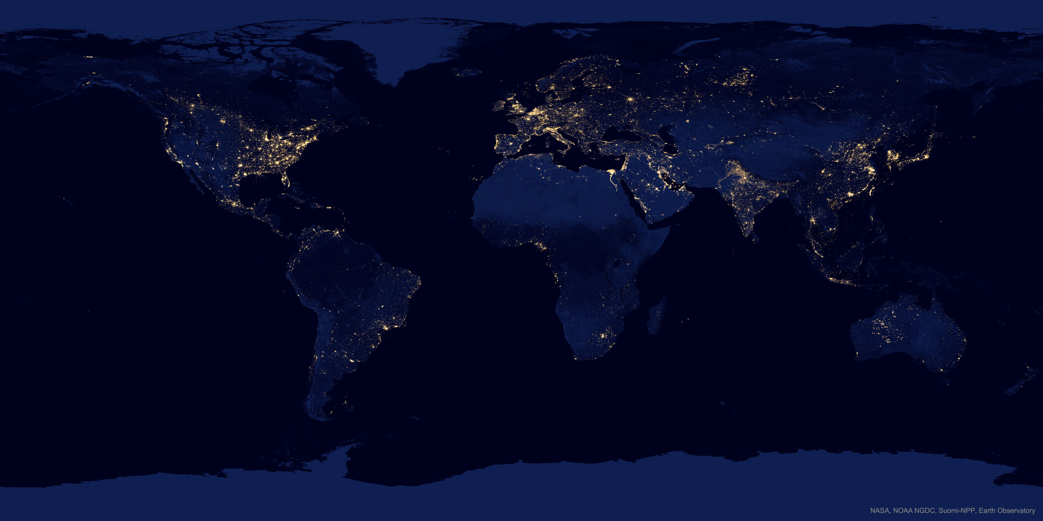
One of my favorites is NASA APOD’s Earth at Night, a composite satellite photo of Earth’s night lights. On it you can see some great features, like
— the line between N and S Korea. N Korea is almost pitch black while S Korea has many lights.
— the mouth of the Nile. So many cities lined along it.
— the bright rivieras of France’s and Italy’s Mediterranean coasts
— in the USA‘s CONUS, the population density differences between east coast, and west, dibided by the Mississippi.
— in Russia, the railroad lines of the Trans-Siberian Railway.
— the Himalayas forming a dark boundary capping (confining) northeast India’s population
— the bright lights of Chicago, Phoenix, Detroit, Las Vegas, and others.
— Canada — so populated in the south, so barren in the north
— Honolulu. Zoom in!
I love this map!
I have a vivid memory of hauling down an old Encyclopedia Britannica atlas to look at a map of Iowa, after being accepted to a college there without having visited the place.
I felt like Stanley examining a map of deepest, darkest Africa before embarking on an expedition.
I love maps and am fascinated by weird borders and geographic anomalies. The Northwest Angle. Point Roberts, WA. Ellis Island, NY/NJ. Baarle-Hertog/Baarle-Nassau. Kaliningrad. Cyprus. The mess between India and Bangladesh. Great stuff to me.
Loved them as a kid, love them now. I use Google Maps a lot, but sometimes I want to see a large area with detail all at once. The size of the computer screen limits how much area I can see at once. If I had used an actual map I never would have taken the route into Ithaca from the West that had us on a curvy road without room for two cars to pass in some places. The road would only have been on a county map. I’ve noticed that road atlases are getting hard to find around here. I used to see them in grocery stores fairly often, but I don’t remember the last time I saw one for sale.
Another map lover here. One of my favorite childhood memories was the arrival of the new National Geographic. I’d immediately grab the map, which kept me busy for at least a few hours.
When we go on hols, before we go (and while we are there) I love mooch around on Google maps and get my bearings. I turn on “terrain” and “traffic” and “street view” and get a feel for how everything looks and to etch into my brain a mental picture of the layout. It makes navigation so much easier when we get there.
I remember when I was a kid and my dad first showed me a map, I pretty much instantly grokked what it was and how it worked. I could spend hours looking at maps, mentally imagining myself flying, birdlike, above the terrain. I also study maps of cities I’m traveling to so I know the lay of the land; ditto trail maps and topo maps when I used to backpack.
P-man, for road atlases hit up a truck stop. I still buy a new one every few years for my vehicle.
I’ve been a map fan forever – since early childhood anyway. There was a time when I collected gas station maps, primarily of Alabama where I was living at the time. I have various atlases even now.
The great things about Google and Yahoo! maps are the ability to zoom into actual streets (often accompanoed by actual photos) and look at actual houses. In many cases you can even “drive around” neighborhoods. I do that frequently!
My main source for weather (http://www.intellicast.com/) features the ability to store separate “home addresses” for friends and loved ones so I can see at a glance (zooming in or out) just what they can be expecting – or are experiencing – in the way of special weather patterns and events. I have five specific locations stored and ready for immediate access. Among those five is the one for Intellicast | Weather Underground which I have “zoomed out” so I can see the whole country for the “big picture.”
I can literally spend hours going over maps and websites “mind traveling” for hours.
