We’re watching an episode of NCIS. ‘McGee’ tells ‘Gibbs’ he’d printed out directions.
When I lived in L.A., I relied on my Thomas Guide. It was indispensable. When I started coming up here to northern Washington, I had (and in fact still do have) a laminated tri-fold map of the Western states. I remember printing out directions from MapQuest even in this century. I can’t remember the last time I did that, now that I have whatever map app is on my iPhone, and Waze.
In the last 10 years, I think I have only ever done it for my route when arriving in South Africa, when I knew I would be switching out SIM cards and didn’t trust that the data connection would be reliable.
My 83 year-old father moved back to the LA area after a 30 year hiatus in Washington State. He refuses to use a smart phone. When he told me he bought a Thomas Guide, I was astounded they still published the things. When I thought about it for a minute I recalled the queasy feeling I get when I drive off without my phone is the same one I got three decades ago when I ended up in a strange neighborhood without my Thomas Guide.
One summer in college I had a job where I drove all over Austin to various residential neighborhoods. I’d get my list of addresses, my Thomas Guide (or whatever it was), solve the traveling salesman problem in my head, and then write out on a notepad brief turn by turn directions to find each place.
Occasionally I definitely had to stop to re-consult the guide and addresses. If I missed a turn my hand written notes didn’t automatically reroute.
Only bad part was it was a Chevy Chevette with an AM radio. I can’t believe it took me half the summer to think to put a boom box in the passenger seat.
That reminds me of a really old episode of the original CSI where Greg Sanders, who has just moved from the lab to being a field investigator, rolls up to a crime scene late and kinda disheveled, so Warrick Brown reads him the riot act about being properly prepared. Along with various pieces of forensic equipment and legal paperwork one might need to work a case, a Thomas Guide was one of Brown’s must-haves.
When I first moved to the Chicago area, in 1989, I bought a large road map of the metropolitan area, from Rand McNally. I knew a lot of people who had a similar map, and it was indispensable for getting around, though it didn’t have all of the smaller streets, so one usually had to rely on oral or written directions if you were, for example, driving to someone’s house.
With Google Maps at least, you can download maps for a specific area, and it will continue to work even without a data connection. They call it “offline maps”. I do that when I plan to drive through areas where I’m not sure I’ll have cell service.
Back in the day, when we did a cross-country driving trip, we used our handy Rand McNally Road Atlas and AAA maps for each state and city we were going through. In the early days of computer navigation, I used to print out Mapquest directions for in-town driving to an unfamiliar place. Nowadays, we don’t often drive long distances, but when we take road trips in-state, we still usually bring a paper map along, just because there are still a lot of cellphone dead zones in New Mexico, especially once you get off the freeways.
The only reality TV show I watch is “The Amazing Race.” It is fun to see the contestants wrestle with a paper map (and stick shifts). Some are ok with them and some really struggle.
Growing up we used paper maps (that’s all there was) and I loved using them and would study them when on long road trips with my parents. I have not used a paper map in ages but I am confident I could still use one pretty easily if I needed to.
My Wife and I will take an atlas with us on loooonnggg road trips. But it’s just for an overview/entertainment for the passenger.
My wifes subaru has a great GPS. The GPS in my 4Runner sucks. Terrible, terrible GUI. We where one time tying to find a specific address, and it just would not take it. We said to hell with it and just used a phone.
I don’t even try to use the GPS in my 4Runner, but I generally know where I’m going.
For decades, Montreal cab drivers always had their copy of the latest “Lovell’s Montreal Street Guide”, in which you could look up any street, and it would give you all the intersections, and the street address at that intersection. It was updated yearly, and old copies are usually available online.
There was a CD version started in the 1990’s, but eventually Google Maps made it obsolete.
As an avid fly fisherman, I do a lot of traveling on various back roads looking for public access points to a wide variety of rivers, streams, lakes, and ponds. Every one of the GPS navigation devices I have ever used will at some point try to take me down some nonexistent road through someone’s pasture, or an old foot path that showed up on a map somewhere, or across a bridge that was removed by a flood or some such many years ago. So I typically vet any GPS provided directions against a paper map (usually my hand-dandy DeLorme Road Atlas for whichever state) to make certain that I’m not being inadvertently sent to somewhere I really don’t want to go!
Getting your Thomas Guide was a rite of passage in Los Angeles. You earned your license, your present was your Guide. If your parents loved you, you got the Los Angeles & Orange County Guide instead of just LA County.
Last map that I bought was three years ago, a plastic folded map of Yellowstone showing the trails, topograhy, and bathroom locations. It was more helpful in looking at before we went than it being useful when we actually got there. It helps sometimes to have a big view map vs looking at one on your phone. When we got there we found that we had cell service in 85% of the park, which was not clear we would have before we went.
I still have a couple/few Thomas Guides for L.A. and Orange Counties, and maybe one for Seattle. I still have that laminated map I mentioned. And I keep my expired aviation sectionals because they make great gift wrap.
My preference is still to print out a google map before leaving, and write critical turns.
We still have paper maps for IL/IN/WI/MI in both of our cars, and regularly get updated ones from rest areas. Not sure whether we still have a Rand McNally atlas. BTW, my dad worked for Rand’s for some 25 years, buying all of their presses and managing several of their plants. My first summer jobs were at their Skokie HQ.
When we got married we bought one of those spiral bound books of the Chicago area, showing every street in the city and suburbs. Took a little skill to be adept at using it.
My wife is FAR more ready to pull out her phone for navigation when driving than I.
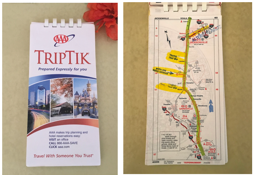
I’ve been a AAA member, on and off, for decades, and access to TripTiks was a big reason why, at least in the pre-smartphone and GPS days.
For those unfamiliar, you could contact your local AAA office, and order a TripTik – a customized set of maps – for a specific journey. I could tell them that I wanted a TripTik for a trip from Green Bay to Sarasota, Florida, and a week or so later, they’d mail me a small, comb-bound map book. It contained a series of segment maps, showing the journey, with the recommended driving route highlighted (with a highlighter marker, even).
They’d also mark the map with known construction areas, congestion areas, etc.
Here’s an example of what they looked like. I think you can still get TripTiks, but they’re computer-generated now.