OK, so somewhere in the foggy recesses of my mind, I recall reading that sea level is different on the West Coast of the US than the East Coast. The figure was something like nine feet different.
I always understood that water will fill a vessel, starting at the lowest point and the top will be level unless it’s being shaken. I’m assuming that it’s the same case with the Earth.
So, where is sea level measured from? It apparently isn’t sea (or ocean) level?
The ‘being shaken’ part is the key here. You’ve got a) the rotation of the earth, b) the swirling of the water from ocean currents c) the moving gravitational pull of the moon and d) I don’t know what else, which can all influence, to a greater or lesser degree, the water level not being exactly level. Doper who know far more about the specifics than I do can hopefully provide more information.
As for measuring “sea level”, I believe an offical average is used as a set benchmark.
A vessel the size of the Pacific and Indian Oceans combined, or the Atlantic is vastly different from a water tank or a teakettle.
One definition of a fluid is that there is no resistance to shear. However, that’s an ideal fluid and water is not ideal. Water has viscosity. If you imagine two horizontal planes lying one atop the other in a body of water, if one plane tries to move relative to the other the visconsity of the water will oppose this motion. Any body of water the size of the earth’s oceans can support quite a difference in level for quite a while before it “levels out.”
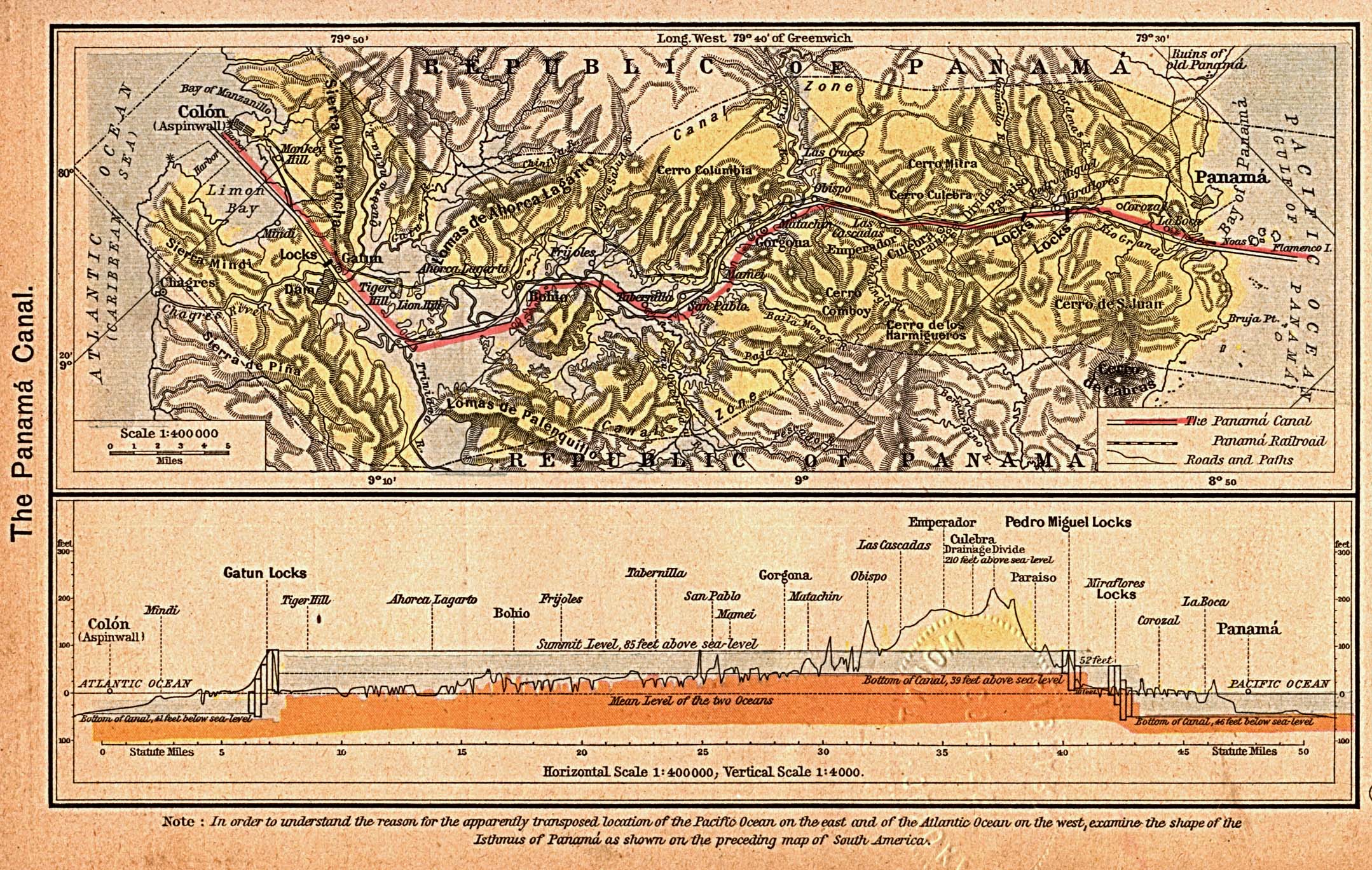
20cm?? Then what’s the deal with the Panama Canal and all those darn locks??? I thought it had something to do with the differing sea levels on the East and West.
danceswithcats link answers that as well, complete with an animated gif:
Unfortunately, “because the oceans differ in level” is sometimes given as a reason in informational blurbs which ought to know better. The lake, Gatun Lake, is 85 feet above sea level. Here’s a map with a cross section:
A fluid having no resistance to shear results in inviscid flow, but I wouldn’t call that a definition. The defining characteristic of a fluid is that fluids continue to deform continuously under the application of a shear stress until such stress is removed.
Suits me.
Back to sea level. In many ways it’s an arbitrary definition. I don’t know the exact details on how it is determined but …
In Washington, DC there is a survey bench mark that is the starting point for all surveys in the US. The bench mark gives, among other things the elevation above mean sea level (msl) at that location.
I assume that msl was originally determined by finding a value for several different sites on the east coast. Then surveying the change in elevation from the msl point at those sites to the location of the master bench mark. Doubtless all of them gave a slightly different elevation above msl for the benchmark since the tides at any location are somewhat dependent on the configuration of the shore line although the mean between high and low might not change so much from place to place. Anyway, the average of the surveyed elevations could be used for the benchmark elevation above msl and that became the standard. Say the benchmark is 100’ above msl as determined by surveys. When a site somewhere in the US is given at 1293’ above msl that means that it is 1193’ above the master bench mark.
When the system was first originated it wasn’t known that the good old solid ground actually waves up and down over time. However, that doesn’t matter. The benchmark is still the defined point of 100’ above msl. That’s why I said it is arbitrary.
I think that now, in the day of laser and radar distance measuring and satellites msl and elevations relative to it might be updated more frequently than in the past. However, there are thousands and thousands of subsidiary benchmarks maintained by the Interior Department all over the US and they all use the Washington benchmark as their starting point. This would make msl adjustments for changing conditions quite a task.