I was just thinking about sea level (yes, I live an exciting life). We define mountains’ and cities’ heights in relation to sea level, but based on what I’ve read, there’s no agreement on where zero sea level is.
In this thread, http://boards.straightdope.com/sdmb/showthread.php?threadid=63129, it’s pointed out that each country calls its own shots as to what sea level is. That’s all fine and good for primitives like 20th-century man, but it seems like an odd bit of inexactitude in a world where scientists are constantly searching for the most precise definition of a meter. (There’s a neat little timeline about this at http://www.mel.nist.gov/div821/museum/timeline.htm).
So I’m turning to you all. Does anyone know if there’s any kind of work going on to define a universal sea level that can be a starting point for measuring the heights of geologic features? NIST didn’t have any info on this, and a web search turned up nothing.
Is it even possible for there to be a universal sea level? If the Earth was a perfect sphere, then you could measure from the exact center of the Earth, but obviously that won’t work. Aside from just picking an arbitrary starting point like they did with time zones, how could a universal sea level be defined?
One thing that confuses the whole thing is the fact that the earth is not uniformly dense. Thus, there are small, local fluctuations in our gravity, so sea level changes very slightly.
When they first learned the earth was round, they thought it was a sphere. As measurement tools became better, they discovered that it resembles a sphereoid. The distance to the center of the earth is about 21km more from the equator than at the poles.
When tools got even better, they discovered that local gravitational effects have sea level fluctuating from the perfect sphereoid by +76m to -102m, a range of 178m.
Darn, manhattan, I had been about to mention Cecil’s column. Here is more info.
The concept of ‘mean sea level’ was first invented in the 1800’s by one of my favourite math nerds, Karl Friedrich Gauss, who was also fascinated by our fair planet (he conducted one of the first major geographical surveys, covering the area now in northeastern Germany and southeastern Denmark). He defined the ‘mathematical surface of the Earth’ to be
Later scientists shortened ‘mathematical surface of the Earth’ to ‘geoid’, in order to keep their papers from getting too long. Another problem is, the surface of the sea does not intersect the direction of gravity at right angles everywhere; currents, salinity and other factors cause it to higher in some spots and lower in others (I get to quote Cecil here though! )
It’s tough even to define exactly what ‘mean sea level’ is. We’d like it to be the geoid, because that’s more-or-less what we mean. (Aside: altitude measured ‘barometrically’ is measuring altitude above the geoid—not altitude above mean sea level—adjusting for atmospheric variations of course.) But the geoid and the actual level of the sea don’t match up as perfectly as we’d like.
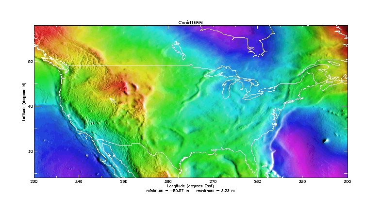
The first attempts were to fit the geoid were oblate spheroids of various sizes, but they didn’t work too well, because the Earth is lumpy, and no matter how you define your spheroid, some parts of the ocean are lower than others. Using the ‘GRS80 reference spheroid’ and the EGM96 gravity field model, the lowest point on the geoid (106 metres, about 350 feet, below the ellipsoid) is off the southern tip of India, and the highest (85 metres above the ellipsoid) is around New Guinea. The models have improved immensely over the past 20 years due to the use of satellites (including, but not exclusively, GPS). Here is a very pretty map of the geoid in the neighbourhood of the coterminous United States. As you can see, it looks kinda lumpy, and although some of the lumps correspond to geographical features (e.g., the Central Valley of California really stands out, as does the eastern edge of the Continental Shelf), not all of them do (e.g., the snakey mount going southwest from the head of Lake Superior).
The problem with sea level is that so many different things effect it. There of course is gravitational strength, both from the moon (tides) and from varying densities of the earth which causes the water to “heap up” over them (as mentioned earlier in the thread). There are currents, winds, and of course, air pressure. Part of the causes of tremendous storm surges is the low pressure under the storm which “pulls” the water up under it.
