Hi guys, want to work on a puzzle I found on a geocache near my house? It’s gone over a year without being solved, which is quite extraordinary. It is a members-only one, so I can’t link to it (unless you are a premium member, then it is GC2Y8CE). Here are the basics:
Bogus coords: N 41° 34.338 W 071° 00.126 Rules say the actual spot must be within a 2mi radius.
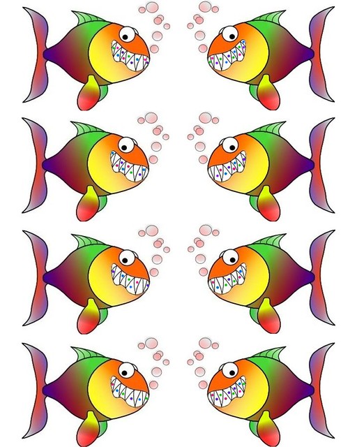
Actual puzzle is housed here: http://farm7.static.flickr.com/6012/5865304948_33774e6f0b_z.jpg
Presumably the left 4 fish are the digits in the Lat, and the right 4 are the Lon digits. (Not 100%, just most likely)
They fit in this coord set: N 41 3 _ . _ _ _ W 070 5 _ . _ _ _
According to the cache owner, the dots are made up of four colors regardless of some off shading, I call them: Green, Red, Blue, Purple
Things I have tried so far: Since some teeth go up and others down, I first tried assigning some numbers to each color and going up and down, but the bottom left fish has 6 “up” teeth and no down, so even assigning low numbers (1,2,3,4) results in double digits. I am not saying this is a dead end, maybe you start with a negative, I just had no luck in this line of thinking.
They form patterns of 12 like this (with the first letter of the color name and ‘.’ for blank teeth):
Left #1 .GRBPRGPB.RP
Left #2 B…RPBRG.PB.
Left #3 .P…B.GBR…P
Left #4 .R.B.G.P.B.G
Right #1 GRPGBPGBRGPB
Right #2 …PRBPRBG.P.
Right #3 .RB.GPG.RB…
Right #4 .RPGRPGPRBG.
So…any ideas?
BTW, if you do come up with a solution, it can be verified at: GeoChecker link for "A Fish Tale"