Speaking as a non-American, I struggled to work out why people were giving her so much shit for noting you could see Russia from her house - my understanding is that, at its narrowest point, there’s only about 50 miles between Alaska and Russia aross the Bering Strait (and Alaska used to be Russian territory until they sold it to the Americans to stop the British getting it). So I get she probably couldn’t literally see Russia from her house, but as a piece of rhetorical hyperbole it seemed perfectly cromulent to me and I never understood why it was the subject of ridicule until now.
She never said she could see Alaska from her house. That was Tina Fey on Saturday Night Live. Palin said “you can actually see Russia from land here in Alaska.”
Most Canadians live south of Seattle.
Since SNL isn’t a thing here* the parody probably got confused with what actually happened somewhere along the way. And Ms Fey was still making fun on Sarah Palin pointing out something that’s certainly cromulent information - Russia and the US are really, really close together geographically.
*I think it’s on pay TV but the overwhelming majority of people in Australia don’t have pay TV. I don’t know anyone here who watches SNL or could name any of the current cast.
Atlanta is closer to Chicago than it is to Miami.
That hurts my head.
I live near Buffalo NY, any farther west and I’d be in Lake Erie or Canada. It takes 7 hours to drive to New York City. NY is a lot bigger than people think.
Mine too. I had to go to the atlas; and, the difference is tiny – but, yes. I suppose the thing is, Florida is very long, and Miami is near its southern tip; and Georgia is big, with Atlanta up at its northern end.
Parts of Virginia are also father north than some of New Jersey.
It’s not that we question the geographical truth of what she said. We question whether being able to see something from within your state makes you an expert on it. She provided that fact while arguing that she could handle foreign policy and foreign relations if she was elected.
By that logic, plantation owners were experts in race relations because they could see black people from their porch. And Israelis living in West Bank settlements should be ideal candidates to negotiate peace with the Palestinians because of how much better they can see the Palestinians.
Yes, tourists always take photos of them.
I don’t know if this is 100% accurate, but I remember hearing that the overwhelming majority of Canadians live within 100 miles of the border.
Mine is in my home town of Sydney. I have this weird disconnect between the eastern and western half of the CBD of about 2 blocks (shifted northwards) - I keep expecting to come out in a different place than I do when walking around.
No, but Perth, Adelaide and Sydney are, for some values of “roughly equal” - 31’6", 34’5" and 33’5" degrees south respectively.
When it comes to that, Adelaide and Tokyo are almost on the same longitude - 138’4" and 139’4" .
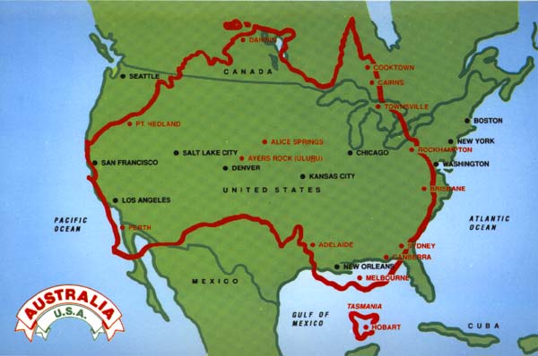
Here’s something a lot of people don’t know: Australia is nearly double the size of non-USSR Europe. It’s only ~10% smaller than the continental USA - with about 1/14th the population.
…and Canada is still bigger. ![]()
I was reading about the history of North American area codes a while ago, and Area Code 819 of Quebec formerly extended into the eastern part of the Arctic. (The Arctic territories are now all in Area Code 867.) So 819 extended from the New York border at 45 degrees north to a point at the North Pole: approximately 5000 km, or 1/8th of the distance around the world.
This is literally tree but kind of unsurprising if you consider that (a) it’s cold, and (b) the big cities that were settled first are along the St. Lawrence and Great Lakes, which are, of course, the border, or close to it.
For me the idea I can’t shake is that Australia and New Zealand are really close, like it’s no big deal to go from Sydney to Wellington. In fact they are quite far apart, about 2000 kilometers.
The US is fairly uniformly settled, unlike Canada.
By our standards that is close, a 3 hour flight from Sydney. Perth is 4.5 hours away.
Well, actually it’s sort of the same way; over two thirds of Americans live within 100 miles of its land or ocean border.
Wouldn’t have guessed that Rick.
As Askance says, by Australasian standards that is close. Brisbane and Sydney are about 1000kms apart but people fly between the two cities all the time like it’s not a big thing at all. Ditto Sydney and Melbourne and Canberra and Brisbane/Sydney/Melbourne. It’s not paticularly expensive, either - BNE-SYD return flights can be had for about $200-$250 depending on when you travel etc.
Despite being New Zealand’s capital, Wellington isn’t its major city - but it’s certainly not a big deal to fly between Brisbane/Sydney/Melbourne and Auckland (or, until a few years ago, Christchurch).
I will admit that Perth and Sydney are a lot farther away from each other than I expected. I’ve flown that route a number of times, and know what to expect now; but the first time from Sydney to Perth, finding that it was a four or five hour flight, left me thinking, “whoa!” I’ll admit, I did not think that Australia was that big. I know better now, of course.
I know a guy from Maine who really believes Maine is the northernmost of the lower 48 states. There are five further north- N. Dakota, Minnesota, Montana, Idaho, and Washington.