The same tilt the MTA gives to New York on subway makes, my brain gives to Europe, putting Russia north, rather than east, of everything.
Also, Afghanistan is west of Iran in my mental map, and Iran north of Iraq.
The same tilt the MTA gives to New York on subway makes, my brain gives to Europe, putting Russia north, rather than east, of everything.
Also, Afghanistan is west of Iran in my mental map, and Iran north of Iraq.
Outside of Alaska, Michigan has the most coastline of any US state.
This! I know better now, but this errant mental image must’ve formed when I was a punk kid slacking in geography, and it’s hard to shake.
Being in San Fransisco not too long ago my cronies and I were having lunch on the Pacific Coast and I wondered what the closest major city SF was in line with by latitude. Turned out to be Tokyo. We were all slightly surprised.
England prefers to keep them upwind. Well, some do.
Naw, you’d enter an alternate universe after passing through the North Pole Singularity, and emerge on an alternate earth where the poles are flopped, all maps would seem upside-down, toilets flush the other way, and kangaroos all over Canada.
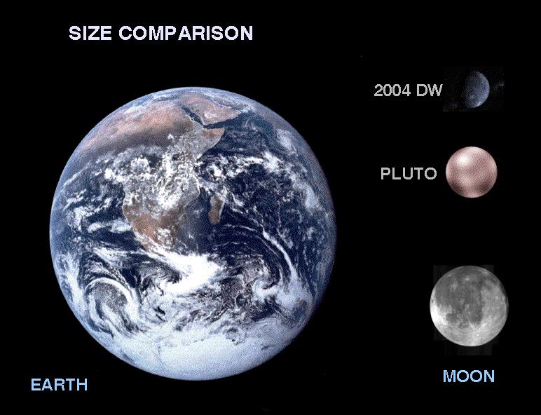
Well, Earth is the largest of the terrestrial planets, Venus being a close second in size. Our moon’s relatively big for its orbital parent. That said, Pluto is about half the size of our moon. Can’t wait to see the real, detailed surface in 2016 with the New Horizons probe.
A modern day Atlantis! And some didn’t believe global warming a reality! Oh the humanity… I hope Oprah (and Cecil) got out okay…
Bermuda and Tahiti were down with the rest of the islands in the Caribbean.
Bermuda not so much… Tahiti’s not even in the same ocean.
Huh. I guess it just sometimes feels like they’re all in Thailand.
Wikipedia says Michigan is #9
But inside of Alaska, it’s too cold to swim.
That appears to be oceanic coastline. Michigan is fresh water.
It always seems to me that Pennsylvania ought to have a coastline. It doesn’t, of course, New Jersey is in the way. It does have a deepwater port, I believe on the Delaware River.
Coastlines are a surprisingly hard thing to calculate. They all basically go infinite or indefinite once you measure closer and closer. I read this thread and then took a Sporcle.com quiz that asked the same question just by chance. I was happy to type in in ‘Michigan’ but it didn’t accept that. The answer it was looking for was Florida but I dispute that one as well. Other states that try to lay claim the same title are California, Minnesota and Maine. Prove any of them wrong definitely and you have just won yourself a math PhD from Harvard or MIT.
But Pennsylvania does have a coast–it’s just on Lake Erie.
Well Method 1 is ocean coasts only, which is why Michigan is not ranked at all, but in Method 2, which the article says “also include the Great Lakes coastlines” Michigan is #9
Yep, very well aware of the fractal-like coastline problem. Even a state like Louisiana, do you count the gulf and river as coastline? Personally I would.
Just looking at both of Michigan’s peninsulas, it’s a clear contender for #2. Maybe it’s just one of those myths you hear being a native Michigander?
There’s this on the Michigan Wikipedia page, FWIW:
[Quote=Wikipedia]
Numerous lakes and marshes mark both peninsulas, and the coast is much indented. Keweenaw Bay, Whitefish Bay, and the Big and Little Bays De Noc are the principal indentations on the Upper Peninsula. The Grand and Little Traverse, Thunder, and Saginaw bays indent the Lower Peninsula. Michigan has the second longest shoreline of any state—3,288 miles (5,292 km),[38] including 1,056 miles (1,699 km) of island shoreline.[39]
[/quote]
Bolding mine.
Mentally I always envision Australia being much further south and more isolated. To me it’s weird that a substantial portion of the continent is in the tropics. I picture Indonesia and Papua/New Guinea as tropical, but I can’t get my head around the fact that so is Darwin, which is less than 500 miles from Timor.
I hear you. I grew up in California, and every 2 or 3 years my family would go “back east” to visit the relatives in Wisconsin. To me, Wisconsin was back east which meant the midwest was stuff like Kansas and the Dakotas. To me, Ohio can’t be midwest, it’s too far east. I still have to mentally readjust “Midwest” -> Great Plains, and “Back East” -> Midwest.
One of Australia’s Torres Strait islands is less than 4km from the PNG coast.
Is anyone else momentarily disoriented in places with different geographical arrangements to where they grew up?
For me, I’m used to places where there is a definite southern boundary. I grew up in the Whitby area, on the northern shore of Lake Ontario. All my life, I’ve had a psychological boundary to my south, both the Lakes and rivers, and the actual US/Canada boundary (“Bridge to USA”!).
So, when I visit Montreal, no problem as long as I stay downtown. Water on the south side, I’m okay. Helsinki? Water on the south side, no problem. And Helsinki’s landscape even looks like Central Ontario.
But… I go to Ottawa or Hamilton? Water on the north side! Aiiee! They’re not like San Francisco or London, which are different enough to continuously remind me of the difference; Ottawa and Hamilton lull me into usual thought habits and then surprise me when I’m trying to navigate.
And both Manitoba and Ontario have long salt-water coasts… on Hudson’s Bay. We forget this, because those areas are so far from the major population centres. (And I spent some time a while ago determining that the northern third of Ontario is a swamp larger than Ireland.)
I’m not. And I’d kind of like to be right now, even though normally I avoid any humid climates warmer than about 28 degrees. I do not do well in hot and humid; I like hot and dry.
Some of my adopted state of Maryland is pretty far from DC; it goes a long way from east to west (although not as far as my home state of Tennessee; the northeast corner of the state is almost as close to New York City as it is to Memphis.
This. I live in Boston now, and I still have to remind myself. I have no idea why NYC has cemented itself in my mind as “north of everything”. One of these days I’ll take the train up to Maine and my entire sense of geography will probably turn itself inside out.
You’d like Hawaii. Perfect climate. Humidity gets blown out to sea by the trade winds. Never too hot. I noticed I had an inordinate number of Canadian classmates at the university there.
The Atlantic entrance to the Panama Canal is West of the Pacific entrance.