I am struck by some numbers. There are something like 7 million people in the Houston metro area, maybe even more. The news reports say that something like 20000 people needed to be rescued from flooded homes and residences…and, something like 100000 people are in some sort of shelter…
If the area is so generally flooded, where are the other 6.9 million people? I don’t see reporting on that. Are they staying in their homes or apartments? Did they leave before the flooding? Or, is the flooded area not as pervasive as the pictures suggest?
I’m really not trying to downplay the scope of the disaster, but, with 8 people known dead after 50 inches of rain, Katrina seems to have produced 250 times as many fatalities and somewhat of a reimagining of both New Orleans and the Gulf Coast.
In Baden Baden, the little river running through town opens into a wide, flat park with nothing but recreational areas…maybe couple of thousand acres…because once in a while, the area floods. They are smart enough not to build any permanent structures there, certainly no housing. May I suggest that no money be spent rebuilding houses destroyed by this flood? Climate change is only making things worse with 250 year storms happening every 10 years or so.
I am a little baffled (in a good way) about the low fatality count as well. It seems like a storm that large would produce more just by chance but it is slow moving and still ongoing. People tend to forget that Katrina, at least in New Orleans, didn’t become a true catastrophe during the peak of the storm itself. The main problem with Katrina is that New Orleans is below sea level and levees failed well after the storm had already passed wiping out entire areas of the city that can probably never be rebuilt again.
Houston is not quite in the same situation but it is still very significant. The loss of life may not be that high but the economic damage is enormous (it is the 4th biggest city in the U.S. after all). Water levels have still not crested, much more rain is expected and people are still trapped in the floodwaters. The good news for now is that the water is warm and mostly stagnant in residential neighborhoods but those factors could also cause huge problems in upcoming days and weeks because it is August in a sub-tropical city. I have lots of friends in Houston and some of them literally can’t evacuate their flooded out houses because all the roads out are impassible so people are trying to figure out how to get them out by boat. Their houses are likely destroyed and many people don’t have insurance that covers that type of flooding so they are going to lose everything when it is over.
Other than the fortunate dearth of loss of life, it is still really, really bad.
The reason the flooding didn’t kill that many people so far (an unknown number of people have drowned and not been found) is that the water was not very deep in most places. Everywhere I saw on the news, it was generally about waist deep or less.
This still does catastrophic damage to the interior of a house - the water inside the place will ruin any flooring and require the place be gutted to the studs to a height of at least 4 feet. It will probably also require replacement of most or all furniture, cabinetry, appliances, doors, and all motor vehicles that were flooded.
So you’re talking about a 50k to 150k bill, per homeowner, roughly.
But all you have to do to live through it is turn the power off and go to an attic. Or make a platform about 5 feet up inside your house. Or go to the roof and camp there a couple days until a boat can rescue you. As long as you saved some water, or get some from the abundant neighbors and rescue workers before 3 days pass, you probably are not going to die.
The way you die :
a. You drive into the water somewhere. Over 20 people have managed to kill themselves this way this storm, at least. I’m half tempted to call those deaths suicides, this is the primary mechanism you can be killed.
b. You go swimming in the floodwaters in a spot where they are moving rapidly and manage to hit something. Or you can’t swim, and go wading in floodwaters and hit a spot where it’s deep.
c. You are elderly and someone leaves you in floodwater and abandons you, or you are forced to drink some of it, or someone leaves you in an un-airconditioned location.
During Katrina, the waters were rising much, much more rapidly, all at once, and they were trapping people all over, at night. Water depth did in fact reach roof height, so people who fled to their attic and didn’t have an axe drowned. Totally different scenario.
It is also possible that there are many dead and unaccounted for–trapped in buildings or cars, swept away by rising waters, and so on. Rescuers are not searching for such people, they are trying to get to living people who can make their distress known.
Houston is a very big place, and not only is it affected but a lot of towns between it and the coast. They got more coverage when the storm was moving onto land, but I rather think they are still in bad shape.
My old roommate lives in Houston. He is not in the flood area. On his FB feed is a video from a friend of his, showing that the road in front of his house has become a creek. The house itself is okay, but the flooding is sure extensive.
As the OP, I’d like to know the true scope of the flooding. The only 2 folk I know in Houston are high and dry. I’m sure damage is extensive, but I’m also confident news media are capable of searching out the worst hit areas…
The issue is that for the last 60+ years, Houston has been pouring concrete all over the place. As a result, there is far less ground to absorb rainfall and the streets become the runoff mechanisms. They drain into the regional bayous, most notably Buffalo and Brays Bayous, and when those fill up, there’s no place for the water to go. Houston is fairly flat, so we get flooding along the bayou drainage areas, freeway intersections, etc. Keep in mind, also, that the bayous have been “flood controlled” - dredged deeper and lined with concrete to reduce the overgrowth and increase water flow.
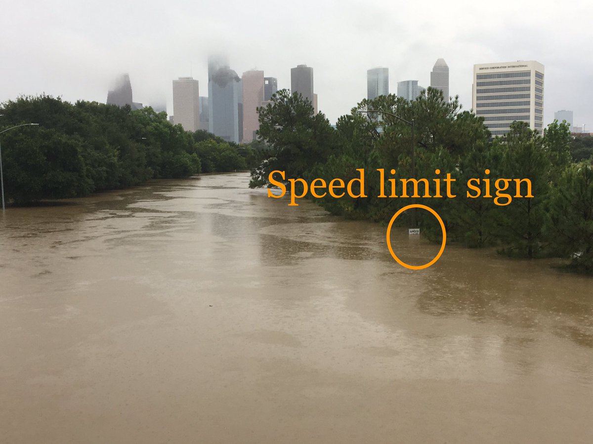
This is Allen Parkway, which runs parallel to Buffalo Bayou going into downtown. Note the speed limit sign. To get that high means the bayou is over the bank by about 20 feet, as Allen Parkway is about 15 feet above the normal bayou line.
Dinsdale : this map here is an estimation. The light grey areas. But the actual true toll will require an exact census of each and every damaged structure. Presumably FEMA or other underwriting agencies will have an exact count, and maybe an estimate of the true percentage of the city.
I’ve heard the actual numbers were less than 10% of all structures in the city - which will still require incredible amounts of money to repair, it could have cost 5% of the value of all the buildings in Houston. Events like this also devalue land - nobody wants to invest in property that is going to flood every 10 years.
My sister’s house was flooded. There was at least two feet of water inside the house (which is a one story house).
The good news is my sister doesn’t live there now. She’s bought a new house and has the old house up for sale. She has flood insurance but I don’t know how much it covers.
The bad news is my niece has been living in the house. She tried staying there but had to be evacuated (by boat) when the water got high. She’s okay but she probably lost a lot of her stuff (including her car).
They are talking about the entire metro area and that is all that counts in situations like this. Storms don’t know anything about political lines or arbitrary boundaries. Houston is gigantic (4th biggest city in the U.S.) and very spread out. The other odd factoid is that it is also the most diverse city in the U.S. even including NYC and Los Angeles. It is a gigantic city that is very spread out but it has little zoning. That makes it very vulnerable to super-storms like this. We already know about the residential people that are affected but I am also curious to know what effect it will have on major industries. Houston is a very major energy hub among many other things. It isn’t the most attractive city in the world but it is vital to lots of things coming in from the Gulf of Mexico and headquarters to major energy companies. If those get significantly affected, it could have a world-wide impact if energy prices spike.
The main thing working in Houston’s favor (as opposed to New Orleans and Katrina) is that Houston is not flat. That means that the water is concentrated in the lower-lying areas.
The main thing working against Houston is that Houston is not flat. That means the water is concentrating in the lower-lying areas. A LOT of water. With not much of anywhere to go.
Thanks. I had looked at those maps, but really didn’t get much of a clear picture from them. Which one are you saying has light grey areas? The only light grey I see is reservoirs. From the “rescue calls” map, you see pockets to the NE and SW, and along waterways.
Like I said, not trying to understate the damage. But from the news footage, you almost get the impression that the entire city is underwater. The blocked roads map suggests what a hassle it must be getting food and supplies in.
My nephew and his GF are dry in their respective homes. The work for one of the refineries, and are currently working from home.
For the rest of the country, there will be 2 noticable effects:
there will be a short uptick in gas prices, but the global glut will keep that under control,
Don’t plan on buying a used car for the next 4-6 months. Even those folks who didn’t have flood insurance have car insurance. Once those checks start coming in, there won’t be a used car left in the country. Baton Rouge La. has extensive rain induced flooding in 2016. 4-6 months after that, local used car dealers were out of stock. When there was a bad flood up in the N.C./Va. area last year, car dealers were buying used cars all over the southeast sight unseen for over the asking price.
And anyone who wants to earn big bucks hanging sheetrock while living rough can do very well in the Houston area for the next couple of years…
/cdn.vox-cdn.com/uploads/chorus_asset/file/9128111/GettyImages_839997590.jpg)
/cdn.vox-cdn.com/uploads/chorus_asset/file/9135679/840248942.jpg)