Naval buff Dopers, help! I can pin down British ships easily, but this US ship is eluding me; it’s on a postcard from the early 1930s (no actual year on the Canal Zone postmark).
The “2 over 3” main turret arrangement should make it easy, but despite hours of browsing on the web (including the very good Haze Gray site: http://www.hazegray.org/ ) I damned if I can can figure out what class this ship is, let alone what ship it may be:
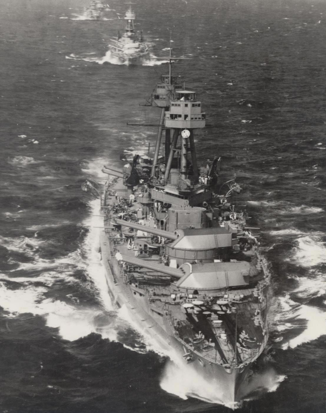
photo one
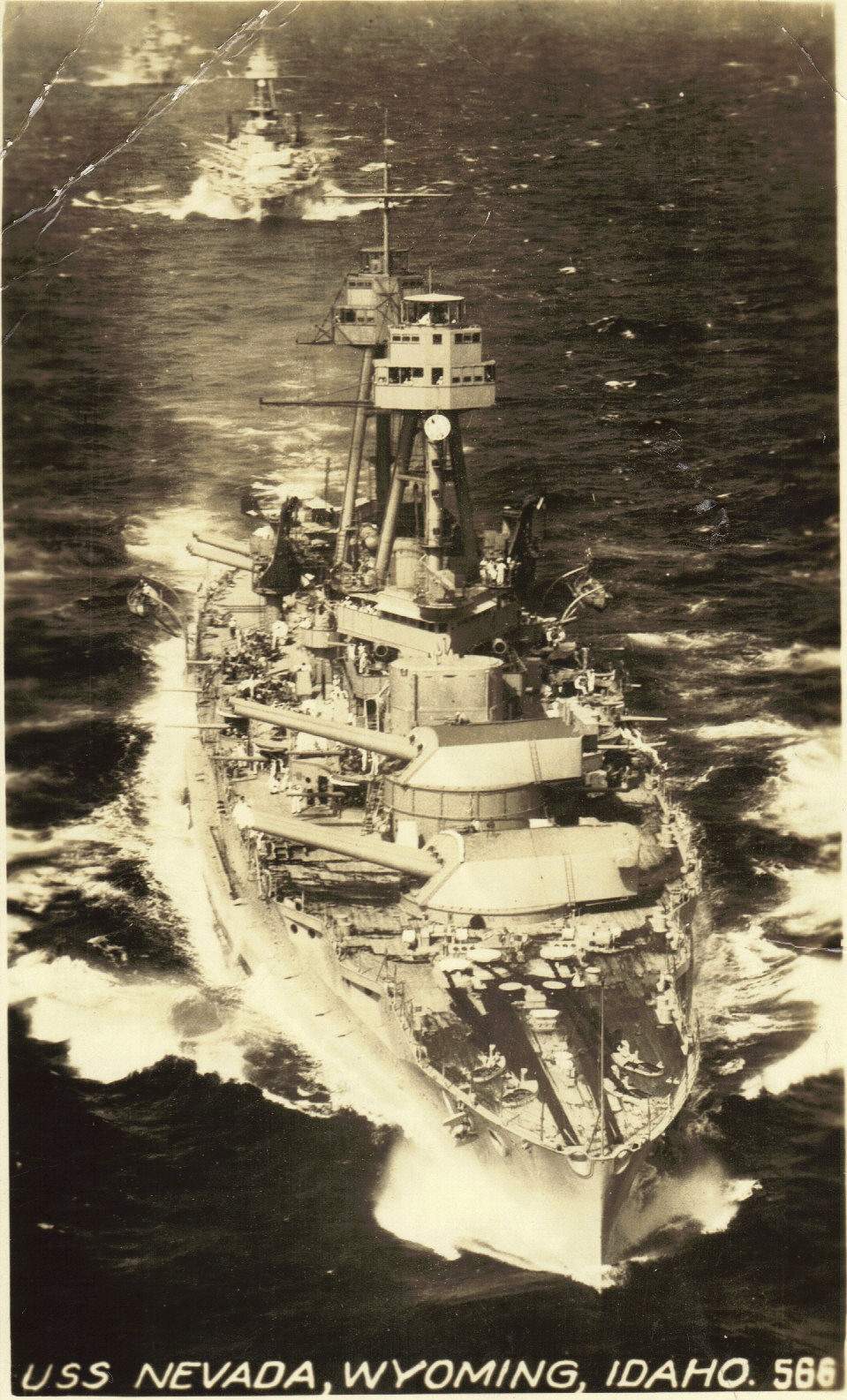
photo two (close-up)
photo two
Any ideas?
I’ll guess the USS Nevada. Same two-over-three forward guns, same flying bridge design.
Ahhh! Thanks, Fear Itself!
I had looked at Nevada, but only at a photo of her first incarnation in WWI, with the openwork superstructures, and that threw me off the trail.
Many thanks!
Well, it has to be either the Nevada or the Oklahoma based on the primary armament.
I’m going to guess the Oklahoma, at the moment.
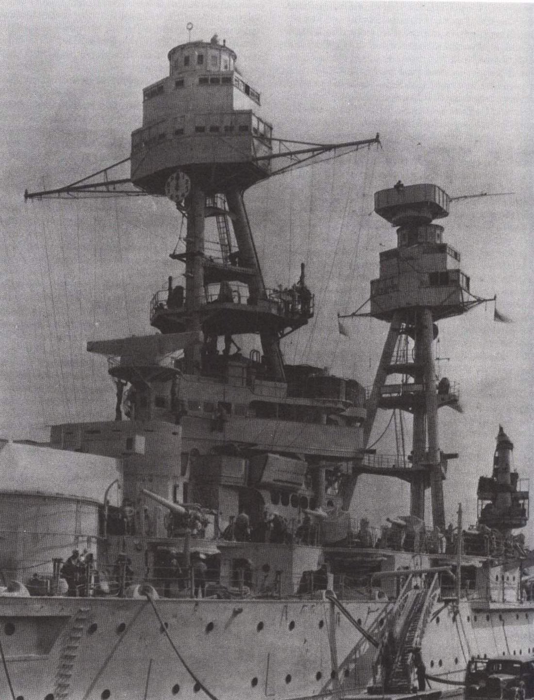
Note in the second photo of the OP that there is a very visible “ledge” starting just aft of the anchors and extending around the curve of the hull.
On this page of Nevada photos, in the second to last photo, (Size 51), such a ledge is not even visible while in the sixth to last photo (Size 111) and the fourth to last photo (Size 85) a ledge can be seen, but does not appear to be prominent.
On the other hand, in these photos of the Oklahoma in the ninth from last (Size 52) and eighth to last (Size 58) the ledge is fairly prominent.
I am putting forth only a guess as I recognize that different lighting will cause identical objects to show up differently in photos. A better measure might be to do a detailed examination on minute differences in rigging, portholes, and such. (At first I found a difference between the Oklahoma having and the Nevada not having a clock below the forward director tower, but other photos showed clocks on both ships.)
Don’t feel bad that you cannot easily identify which is which. The NavSource.org gallery has the same photo (with different levels of clarity–one possibly taken from a newspaper) identified as both the Oklahoma (tenth from bottom on its page, (Size 52), (http://www.navsource.org/archives/01/013749.jpg, but I cannot get a direct link to work) and as the Nevada (grainier, more washed out photo) on its page, eleventh from bottom, (Size 95) (http://www.navsource.org/archives/01/013628.jpg same issue of link).
(Ignoring the bow waves and wakes that could conceivably be the same for two ships with the same hull design going the same speed, you’ll notice that the scattered whitecaps and other waves away from the ships are in the same locations, as well.)
What’s with that clock? Why does it have markings for only 1 to 10? Is it more of a timer, rather than a time-of-day clock?
Thanks, tomndebb; I think you’ve likely narrowed it down to the Oklahoma for me.
The “clock,” I’m fairly certain is a device akin to one used in coast artillery forts, to help signal target information to another battery (we had an almost exactly similar device in one of the batteries of Fort Rodd Hill in the 1920s). As used on land, it was a backup system for sigs, in case the magneto phone (a land-line with “armoured” cables) was broken up by enemy shelling.
The “clock” was used to transmit range information at the coast fort–but assuming that each gradation on the Okie clock stands for 1000 yards, 10,000 yards seems awfully short for 14-inch guns, even given limitations for elevation. Perhaps (and now we’re into WAG territory) in peacetime practices 10,000 was the standard range limit for firing to save on propellant and wear on the guns (which seems unlikely, and unrealistic)?
- On preview, I see that Scruloose found a better link than I’ve been able to scrounge up.
Thanks, Sculoose and Rodd Hill, for the explanation.
Ah HA! I think I have found clear evidence that it is the Oklahoma.
In this photo from the OP, there is an open platform crowded with sailors just below the ranging dial that I earlier mistook for a clock.
Notice how high it is along the tripod.
Now, compare the photos on the NavSource Nevada page looking particularly at
the second from the bottom (Size 51) link http://www.navsource.org/archives/01/013657.jpg (if it will work)
the sixth from the bottom (Size 111) link http://www.navsource.org/archives/01/013627.jpg
and the fifth from the bottom (Size 216) link http://www.navsource.org/archives/01/013616.jpg
Note that the equivalent platform is quite a bit lower on the tripod (there is even room for a small platform above it that does not extend out beyond the tripod legs) and that the front of the platform is interrupted by the midships tripod leg.
In contrast, on the NavSource Oklahoma page, look at
the fourth from bottom (Size 91) link http://www.navsource.org/archives/01/013718.jpg
the sixth from bottom (Size 62)link http://www.navsource.org/archives/01/013712.jpg
and the twelfth from the bottom (Size 140) link http://www.navsource.org/archives/01/013703.jpg
Note how high on the tripod the platform is mounted and that it extends forward of the midships tripod leg.
(I’m not convinced that the “ledge” I saw earlier might not be a trick of light in the photos, but the open platform’s position is pretty clear.)