I have the latitude and longitude of a point, say N 40 00 00, W 75 00 00. I want to find the latitude (with great precision!) of a point exactly 10 statute miles due south (so my second point is on the same meridian as my starting point).
My question: In doing this, does the fact that the earth is an oblate spheroid rather than a perfect sphere factor into it at all? Seems to me that if you walked the same distance on the two different shapes, you would wind up at slightly different latitudes, but I’m unschooled in these things.
I found a little program on the web called Geocalc which will give me a latitude, but I don’t know if it takes the flattening factor into account or even if it needs to. If it does matter, do you know of a program or set of equations I could use to get a good result?
How great is “great precision”? If you only need to know the difference between the two latitudes to about 1% or so, then you’re probably OK using the naive spherical approximation; the Earth’s oblateness is about a one-in-a-thousand effect. In particular, 10 statute miles will translate to a latitude difference of about 1.4 seconds of arc (I think).
Unfortunately, various schemes are used. The simplest is to assume a spherical earth with a radius that is some compromise between that at the equator and the poles. One standard spherical radius (used in the measurement of aviation records) is 6371.0 km.
Another approach is to use a spherical earth model with a radius appropriate for the latitudes being considered. Provided the latitudes involved in a calculation don’t vary much (as in the case mentioned in the OP), this will give very good accuracy.
And some schemes are iterative: they assume a non-spherical and thus don’t use a constant radius.
Obviously, there’s an inherent tradeoff between ease of calculation and accuracy.
The length of a degree of latitude varies from 69.407 miles at the poles to 68.703 miles at the Equator. Put another way, 10 miles will cover 8.73 arcminutes at the Equator and 8.64 minutes at the poles. The formula for interpolating between these values would involve sines and cosines, and I’d probably get it wrong, so I’ll defer to someone else to post it.
That Geocalc program probably does it right. The question is, what does it do right?
“10 statute miles south” doesn’t quite define the problem. It has different meanings for different methods.
Now you seem to want it to be along some ellipsoid rather than some map projection . If you really want to be precise you need to know some more things.
Which datum/reference frame do you want to use (i.e. what is the shape and orientation of the ellipsoid)?
Are you assuming 10 miles at a constant height above the ellipsoid, a constant mean-sea-level height, or with both points at zero height on the ellipsoid?
If the Geocalc program (there are probably dozens of different ones with the same name) doesn’t give you the option to select the ellipsoid, it is probably using something like NAD83 (which is likely fine for you). If it doesn’t ask you your altitude, it is probably assuming both points are at zero height on the ellipsoid (which may or may not be what you want).
Anyway, there are a lot of programs out there but I use this one from the Royal Netherlands Navy Hydrographic Service. It does a lot more than I even have heard of.
If I haven’t lost all my credibility already with the above series of posts, here’s what I think is the best way to do it.
If you assume a perfectly ellipsoid earth, then your north-south path lies on an ellipse whose semimajor axis is the equatorial diameter of the Earth (call it a) and whose semiminor axis is the polar radius of the earth (call it b). So essentially want to find the angle subtended by an arc of a given length, starting at a given latitude, on an ellipse with known a and b. It can be shown (e.g. here) that the arc length of the arc subtended on the ellipse between angles alpha and beta is given by
length = a * integral (sqrt(1 - e[sup]2[/sup] sin[sup]2[/sup] theta) d theta),
where e is the eccentricity of the ellipse, given by e[sup]2[/sup] = (a[sup]2[/sup] - b[sup]2[/sup])/a[sup]2[/sup], and the integral runs between alpha and beta. (Note, by the way, that alpha and beta are measured from the North Pole, not the equator as latitudes are.)
So if you know alpha (your starting latitude), a, e, and the length you want, you can in principle solve for beta (your ending latitude.) Unfortunately, the elliptic integrals aren’t nice functions like sine or cosine, so you have to look up the results in tables or use a program like Mathematica to solve this. I’ve got access to Mathematica here, so if you want send me the actual values you’re using (I’m assuming you don’t want exactly 40 N, 75 W) and I’ll plug it in to Mathematica.
If great precision means correct to 0.0000001 degree, then no doubt you’ve seen the online calculators that do that, now. But if you want precision a thousand times better, then the best choice is the formulas that B. R. Bowring published a few decades ago. You use one formula to get the distance from the equator to latitude 40 degrees, subtract 10 miles from that distance, then use another formula to get the corresponding latitude. If you’ve got five constants written down, for your chosen spheroid, you can do it in 2-3 minutes on a scientific calculator even if you haven’t already programmed it. As of now Wikipedia still has his formulas, under “Meridian distance” at
Geocalc has the data for many definitions of earths shape, (earths sealevel ) and allows for customisation to them.
Maybe the question is , how do the experts deal with the shape of the earth ?
They use datums.
Geocalc says this about datums.
Vertical Datum Support for True Height Conversion
GeoCalc is equipped with powerful Geoid Model or Vertical Datum support, including support for NOAA’s VDatum systems. The tool supports nearly eighty geoid definitions, including US, Australian, European, Canadian, Worldwide, and many other location-specific models. Additionally, GeoCalc supports the ability to create custom vertical transformation grid formats giving your users the ability to make their own geoid models. GeoCalc also includes local offset height models for vertical transformations to give users the ability to create custom offsets from geoid definitions. These tools make GeoCalc a uniquely powerful LiDAR processing toolkit enabling highly accurate, true 3-D data transformation support.
Of course, a datum is not the Earth. It’s easy to pick a datum and solve the OP’s question based on that. But the Earth is not an oblate spheroid; it’s a lumpy oblate spheroid, with various mass concentrations that affect distances. And this isn’t even counting the fact that there might be a mountain in your way, so you have to decide if the 10 miles is actual surface distance, or a theoretical one based on the the geoid. Oh, and if you’re picking the actual Earth, you have to pick a length scale, since otherwise you run into the coastline paradox.
But I took the question to saying “We have a problem with calculating horizontal distance, how do the experts handle that ? “They use a datum. Its not an actual distance,
Of course if we walk on the real earth, we rise or drop in height too, and then we get into the coastline paradox .. what approximation/assumption do we make about the path ?
It’s a perfectly reasonable interpretation! And that is how the experts do it. But if you want to know if you’ve really gone 10 miles… there are still some questions.
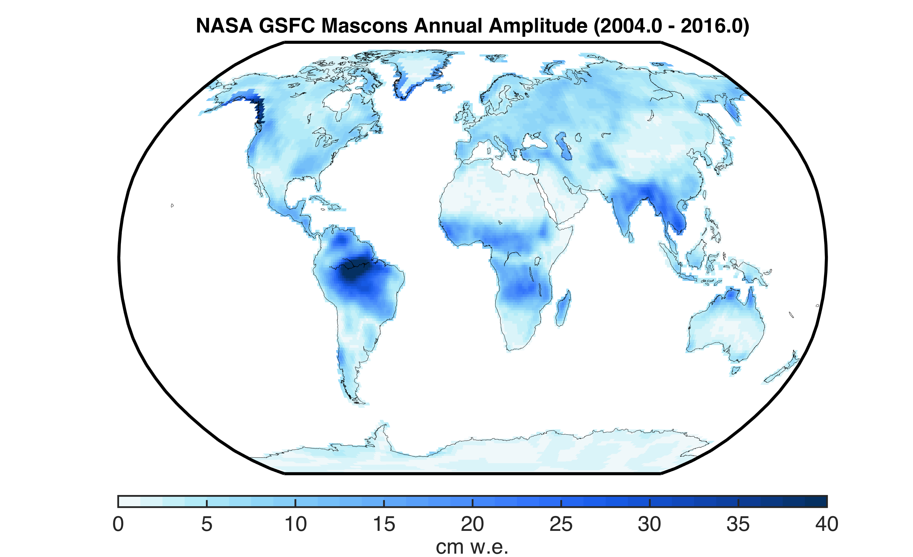
Here’s a map of the mascons (mass concentrations) on Earth:
The scale is “centimeters of water equivalent”. How do we incorporate it? Well, that’s a little tricky… but we could think of it as raising the effective (virtual) sea level. And that means you’ve increased Earth’s radius a tad, making that 10 miles on the actual geoid a little longer than 10 miles on the datum.
The map above isn’t quite detailed enough to tell what’s happening on a 10-mile scale. And 40N, 70W seems to be a bit off the coast of Rhode Island. Let’s say you’re in the Amazon instead, where the mascon amplitude is maxed out at 40 cm.
It’s only a difference of about 60 parts per billion compared to the radius of the Earth. Which, over 10 miles, is about a millimeter. Actually surprisingly large! If I’ve done my math right, which I probably haven’t. I’d have thought the error would be more like micrometers.
Although we define the shape of the Earth with WSG-84, we don’t tend to map things at local scales in that space. We choose mapping systems to match the use case. And that usually means rectilinear grids defined on flat planes that cut the geoid. They have a local datum. Locations are expressed as eastings and northings, in meters.
In a different life I wrangled potential fields data obtained for geological exploration. Aircraft fly in one coordinate space, the ground might be mapped in another and you will discover that the altitude of the datum’s used don’t match. Hilarity ensues when your estimated depth to an ore deposit is in the air. We will use any data that sheds light on the question. Satellite gravity over oceans, people walking about with magnetometers, gravity data of any kind. More coordinate spaces than you could ever want.
One gets used to being extremely precise about datums.