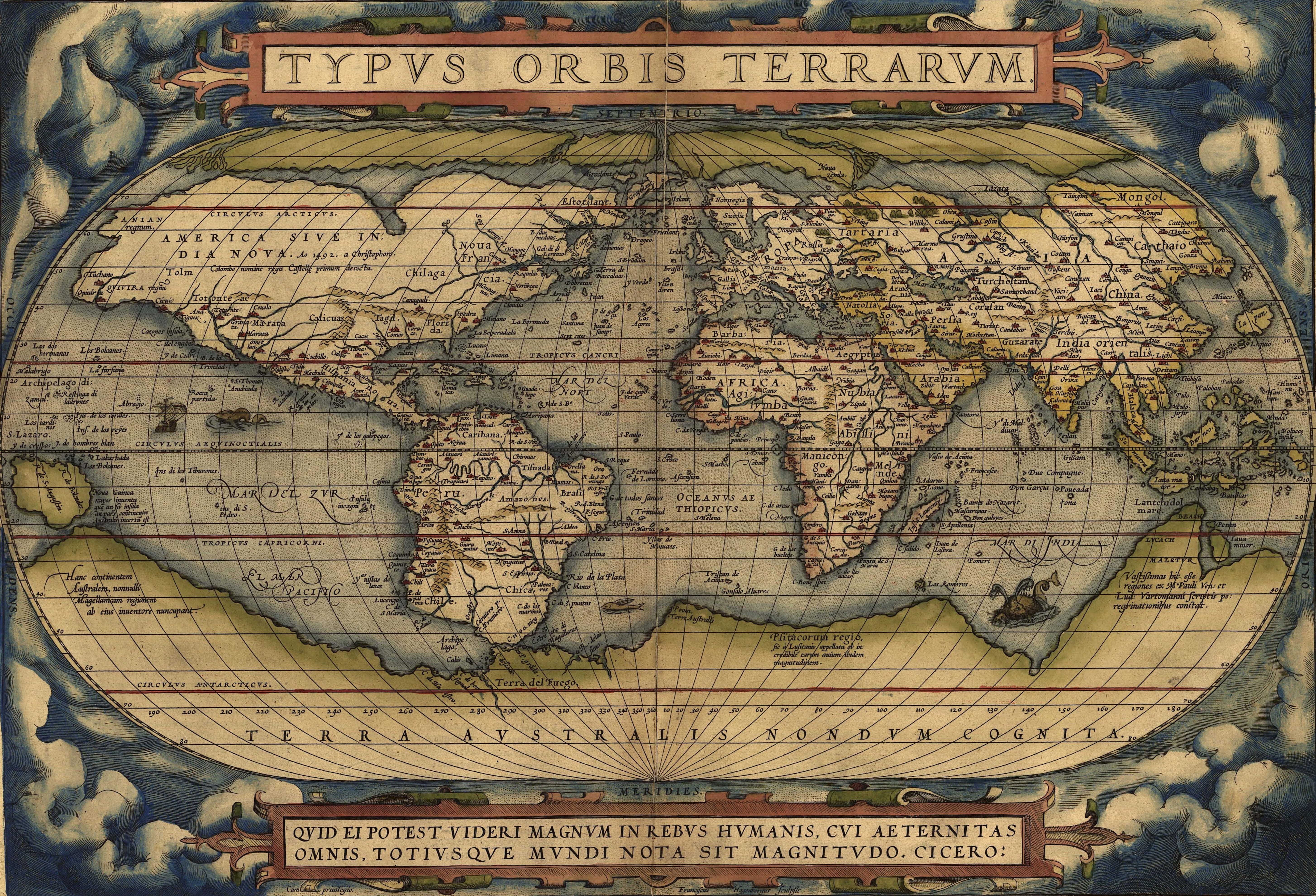
I was looking at the famous 1570 “Typus Orbis Terrarum” map of Ortelius (link to JPEG file, about 7 MB) and noticed that even though the coastlines of the continents are represented reasonably accurately (with the exception of Antarctica and Australia, which are lumped together to the mystical “Terra Australis”), the continents outside Europe are dotted with named cities. For instance, there’s a city labelled Norobega somewhere in what seems to be Maine, or a Modano in the Carolinas.
Where did cartographers take such cities and their names? Did they merely make them up just arbitrarily? That would be kind of odd, considering the care they took with coastlines, regions, and rivers. It can’t be existing East Asian cities whose existence Europeans knew about and which they simply misplaced on a map - this is a time when the identities of America and Asia as distinct continents was firmly known. Or did they take the names of mythical places that Europeans had heard about and put them on the map as a named city in a location that’s somewhere in the area where the legend came from?
I expect a lot of them are basically rumors. Mapmakers don’t like empty areas on their maps, so in the absence of definite information, they put less definite info.
An example of this is all the islands in the north Atlantic. Yes, there’s the Azores, Bermuda, Canaries, and an unlabeled island that’s undoubtedly Madiera, but there’s a bunch of others. These fictional islands have a long history on other maps, some going back a century or more before Columbus. For example, the one labeled “Sept cites” was often called Antillia:
There’s also Brasil (near Ireland) and S Bradain (St Brendan’s Island) and others I don’t recognize off-hand.
Map makers collected charts made by voyagers to create their maps. These included place names. These voyagers had a variety of naming conventions. One was naming a place after a crew member, saint, patron, or sovereign. Modano is an Italian surname and I wouldn’t be surprised if the place in the Carolinas was named for a person on the ship or known to the person charting the coast.
Back when I was a teen, my scout troop went on a canoeing trip, and spent one night on a small island in Georgian Bay. We couldn’t find any name for it on any of our maps, and so determined that we had the right to name it Troop 515 Island. If that decision of ours had ever made it onto a map, and that map were ever found by historians centuries later, it wouldn’t mean that there was a city there.
Bear in mind that mapmakers didn’t do their own charting - sometimes they received first-hand surveys, but mostly, they collated info from older maps. That means that if some explorer or mapmaker made a mistake at some point, that same mistake would reappear over and over again in maps for decades, even centuries.
Purely guessing, but maybe some of these “cities” were just places where mariners could run in and find refuge in a secure anchorage, replenish their water supplies, etc.
I’ve heard that railroads use nonexistent city names to identify specific locations on their lines, such as a place where two lines cross - out in the boonies.
In more modern times, mapmakers have been known to place made-up cities on their maps to catch anyone who was copying their work. One map of Michigan had cities “Mgoblue” and “Beatosu” - in the small strip of Ohio shown at the bottom of the map.
From what I read of building the Canadian Pacific railway across unsettled territory, they build a siding every 6(?) miles and made up names for each of them. The main refueling stops were turned into towns.
Maybe just a loathing of leaving blank spaces. Many years ago, I noticed many globes and maps of Canada used to feature Reindeer Lake on the border of northern Saskatchewan and Manitoba, as prominently as cities like Calgary, Winnipeg or Regina, simply because it was a blank area (and possibly copying someone who did so originally) even though this was a fly-in native settlement, a few hundred people at most, no other claim to fame.
That was bascially true of all railroad companies in the west. They were often building through some very sparsely populated areas, so they ended up naming a lot of places. Some of those names didn’t survive, being renamed by the eventual settlers.
The stations on the Canadian National/Grand Trunk line through the prairie provinces were given alphabetical names:
That wasn’t the only place that alphabetical names were given. There’s at least three lines in the US that did the same, although I don’t think any got through the alphabet more than once.