During the current Denali-v.-Mt.McKinley tiff, it was noted that Campbell Hill was the highest place in Ohio. As you can see from the photos at the link, ‘ascending’ Campbell Hill isn’t exactly a challenge: drive to the parking lot in the background, walk up a slight rise, and you’ve ‘bagged’ the ‘peak’ that’s the highest place in Ohio.
Less well-manicured, but with even more level surroundings, there’s Kansas’ Mt. Sunflower.
On a field trip we learned we were just below the highest point in Oklahoma, Black Mesa at 4,973 feet. We piled out of the van and raced to the top, about a 10 minute climb from the highway below.
Only sluggards take the easy way out and drive to the parking lot.
Climb up from the surrounding flatlands and you’ll definitely need bottled oxygen and a couple of local Sherpas. Here are some intrepid climbers who made the ascent last January, before heading off to bag Hawkeye Point in Iowa (1,670 feet).
Timms Hill, the highest point in Wisconsin (1951 ft) has a hiking trail which goes to the summit, and it sounds like it’s not a difficult hike at all (the hardest part seems to be locating it!):
It would be rather difficult to do any easier than Florida, which has basically no hills at all. Were it not for the fact that its highest point has a granite marker showing where it is, you could stroll by it taking an ordinary walk and never know you’d “ascended” anything.
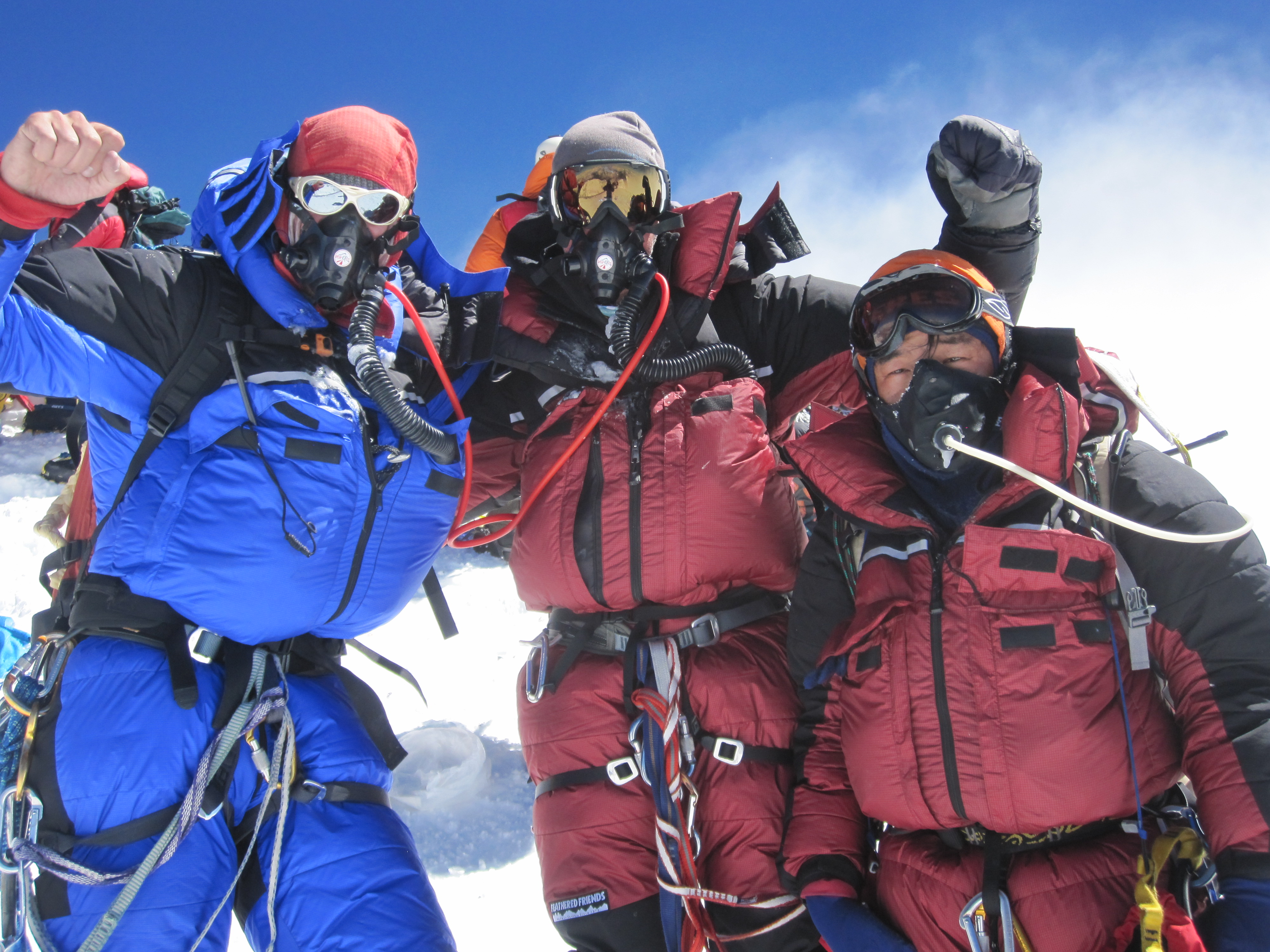
There’s a handy list at peakbagger.comhere.Of the fifty high points, five require real mountaineering skills: Mount McKinley (Denali) in Alaska; Washington’s Mount Rainier and Oregon’s Mount Hood in the Pacific Northwest; and Montana’s Granite Peak and Wyoming’s Gannett Peak in the Rockies. ** Another five or so** (Rhode island, Illinois, Kentucky, and others) are on private land and require landowner permission.
**Most of the remaining state summits are easy hikes or drive-ups. ** Hiking the cool forests of the Appalachians, exploring the windy, lonely high plains, and backpacking above treeline in the western mountains are all part of the great fun of this scavenger hunt.
Jeremoth Hill used to be one of the hardest highpoints to legally scale. While the high point was open to the public, the access was via private land and closed. That has been resolved now, and access is open to the public again.
I’m not sure if there are any states besides Colorado where you can drive on pavement above 14,000 feet.
I guess this isn’t technically in the spirit of the OP, since Mt. Evans is not the highest point in Colorado. Still, since the lowest point in Colorado is higher than the highest point in more than a third of the states, I’m not sure that it really matters much.
And of course, there’s Pikes Peak, also drivable to the top.
Was kind of wondering why Mount Elbert (Colorado) and Mauna Kea (Hawaii) aren’t included in this short list. I guess with Mount Elbert, you’re not actually climbing a full 14,400 feet since you’re starting off so high already at ground level.
How about Mauna Kea? Not very steep, perhaps?
EDIT: Never mind … this pic seems to answer the question about Mauna Kea.
That’s definitely not Mount Hood. The summit of Mount Hood is snow covered year-round. If the file name is to be believed, it’s Mount McLoughlin down near Medford, which is a strenuous but non-technical climb.
Mt Elbert is a walk up, no technical climbing skills needed. It has nothing to do with the elevation, but with technical climbing skills (such as setting ropes and protection, glacier travel, and self-arrest).
Yes, it’s open now, and it’s an easy climb (I’ve heard). There’s still some question if the landfill in Johnston is actually the highest point in the state.
I searched that image on google and found this page which identifies that picture as: “Mazamas, on Mt.McLoughlin, OHQ 1-02.” This page describes the “climb” as more of a strenuous hike:A lot of people lately seem to be indicating that this trail is really, really difficult, so I felt like I should write a preamble. If you plan to hike Mount McLoughlin, know that it is a physically strenous undertaking. This is the highest mountain between the Three Sisters and Mt. Shasta. Bring a GPS and/or maps, know how to use them. Know where you are starting and finishing and let someone know when you’ll be back home. It’s about 5000 feet in elevation higher at the summit than at the trailhead, which means probably 15 degrees F cooler, or more. There can be fine weather at the trailhead, while heavy fog and frost reigns at the top. Be prepared!
Yeah, if you want to stretch the definition of “most” so that it excludes, at a minimum, the high points of California, Idaho, Nevada, Hawaii, Arizona, Utah, New Mexico, Colorado, and Texas. None of these could possibly be described as “easy hikes or drive-ups”.