For some reason, I’m having a hard time finding this out. For the purposes of my question, ‘land’ does not include ice, just solid ground above sea level. So ice shelves and polar ice caps don’t count. I was tempted to say ‘dry land’, but it doesn’t matter if it’s covered in ice as long as a drill sample would hit dirt before sea level.
I’d also like to know the corollary for the surface inside the the Antarctic Circle - again ignoring ice shelves.
The overall area of the Arctic Ocean is about 5.4 million square miles, which leaves about 2.3 million square miles of land. (Geographers seem to be nice enough to have declared the Arctic Ocean only extends as far south as the Arctic Circle.)
This one is fairly easy. There is no land inside the Antarctic circle except for Antarctica. There is a small amount of Antarctic land which juts outside the Circle. The ice shelves are large compared to humans, but not large compared to the continent as a whole.
Ref Geography of Antarctica - Wikipedia, the land area is approximately 5.4M square miles. Per @Kent_Clark’s number for total land area of Earth at 57.3M square miles, Antarctica represents ~9-1/2% of the Earth’s land area.
Yes, there’s some uncertainty in these cites and in my calcs about how much land is outside the circle and whether the ice shelves are mistakenly included in the land areas. But those are just rounding errors in the overall result.
Not so fast - much of the ice sheet in Central Greenland and West Antarctica is grounded way below sea level. It might look like land area on the maps but the OP specifically asked about hitting dirt above sea level.
This was my thought too - maps I’ve seen of Greenland elevation show a fairly large “central sea” if there were no ice cap. Similarly, there are maps that show a fairly large bay covering over 1/4 of Antacrtica, land below sea level. Presumably (a) much of this is approximate and (b) how much would the land rebound if that weight is lifted, and espcially (c) if the ice disappeared, the sea levels would rise noticeably. https://www.reddit.com/r/geography/comments/szwyog/topography_of_greenland/
This shows an even less “land” portion of Antarctica
I suspect the OP did not mean that literally. Although you are 100% right about his literal words.
IOW …
I doubt he’d consider fully landlocked inland areas that are below sea level as not being land. That would also make the US’s Death Valley or Egypt’s Qattara depression into not-land.
To the degree we’re talking what would be bays or estuaries if it was warm enough to be liquid water, then yes, that would IMO count was water not land. But probably already does so in the cites for total land area.
In areas where glaciers become ice shelves there is certainly the concept of the “grounding line”. Starting from the open sea and proceeding towards land, the grounding line is the first place an ice shelf touches bottom. See [u]https://en.wikipedia.org/wiki/Marine_ice_sheet_instability[/u].
There are some areas (not specifically called out detailed in that article) where there’s a depression behind the grounding line that is deeper. That would fill with water if the glacier above disappeared.
As a total fraction of all of Antarctica, IMO that’s still a small factor. And as to Antarctica’s contribution to the Earth’s land area, just a rounding error.
Good eye for detail though; I’d totally missed that nuance.
Well, yes. So are fully inland depressed areas that are covered with ice sheet.
The distinction that matters for area or for the OP’s rubric is whether any particular spot of below-sea-level land elevation has a continuous open path from the sea or not.
The Arctic Ocean, not the arctic circle. You can’t just subtract the area of of the Arctic Ocean to calculate a decent approximation of the land area inside the arctic circle because bits of it extend below the Arctic Circle. At least that’s my interpretation of the comment.
I just had an idea (don’t panic), though. When the ice finishes melting and the arctic ocean rises and covers the land north of the arctic circle, it might be a circle then.
My OP was perhaps underspecified. Still, I see that others are seeing my difficulty in getting some solid numbers.
To clarify - I’m looking for land above current sea level, so imagine the ice has been removed without melting. Let’s assume that there are no Death Valleys or Dead Sea regions that are dry but below sea level. So Antarctica becomes a very complex shape that’s maybe - what, a half?- as big as it looks with the ice coverage. The same for the parts of Greenland above the Arctic Circle, and maybe some of Siberia and the NWT for all I know.
I’m also not so much looking for the percent of the (total Earth’s surface) or % of (Earth’s total land area) that’s above sea level in those places. I’m looking for the the percent of the (total surface contained in the Arctic/Antarctic Circles) that’s above sea level - you’re starting with a smaller denominator (about 4% of the total surface area of Earth, each).
As things look to the naked eye on an ordinary map, Antarctica fills about 70% of the Antarctic Circle, while Greenland/Siberia/Finland/Canada/Alaska cover a smaller percentage of the Arctic Circle. But is that still true for just land above sea level?
It’s still true that the Antarctic land is centrally positioned and higher on average than the Arctic land, but is the total land coverage as different for the two polar regions as we might think?
Only a small (~5-10%) of the visual area of Antarctica is floating ice shelf. All the rest is rocky continent above sea level. So 90/95% of the part that’s solid is rock, not floating ice.
This is instructive: Wiki pic. Note how much isn’t ice shelf.
Point being that Antarctica is not a small island surrounded by a vast expanse of attached floating ice. Instead it’s a large continent with a couple of rather big bays that are frozen over with floating ice and the rest of the rocky perimeter has a thin rim of ice hanging off much, but not all, of it.
To put it in planetary perspective, Antarctica is not quite double the size of Australia, and almost 7 times the size of Greenland. Or half again larger than the USA. Or 90% of the size of Russia proper. It is big. Very big.
As to areas:
Per Antarctic Circle - Wikipedia the total area of the Circle is 7.7M square miles. Per my earlier post’s Wiki cite the land area of Antarctica is 5.4M square miles. So the land occupies 70% of the Circle. Plus minus a small bit of land outside the Circle and any vagaries about how exactly Wiki’s source for that number determined the land/ice boundary. And rounding.
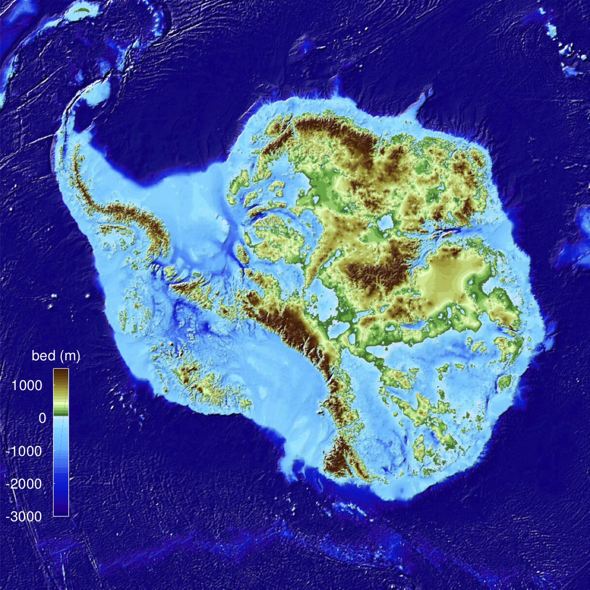
That doesn’t really square with the below. If you somehow scraped off all ice down to sea level, it only looks like only about 50% of the continent would be “land”.
I’m not competent / motivated to resolve this, but as best I can interpret the color scheme of your cite, anything blue-ish or whitish is at/below sea level. Which would have the results you suggest, barely 50% of what looks like continent is actually land.
One of the problems with evaluating that map is something called rebound. When there’s 3 to 5 km of ice on top of a piece of land, it gets pushed down. Some above sea-level land is depressed to below sea-level. If the ice is removed, that land is going to spring upward. At first, the rebound will be fairly rapid, but it’ll go on at a decreasing rate for many thousands of years. For example, the land in northern Europe and northern N America is still rebounding some 10 thousand years after the last Ice Age ended.