I happened to spot Harsens Island in Michigan which is north of Canada’s Walpole Island. I know there is an area in Niagara Falls State Park that is north of Canada also. Are there more such areas along the border?
If you look at the southernmost point in Ontario (the red dot on the map below) the answer to “places where the US is north of Canada” is “all or part of 27 states”.
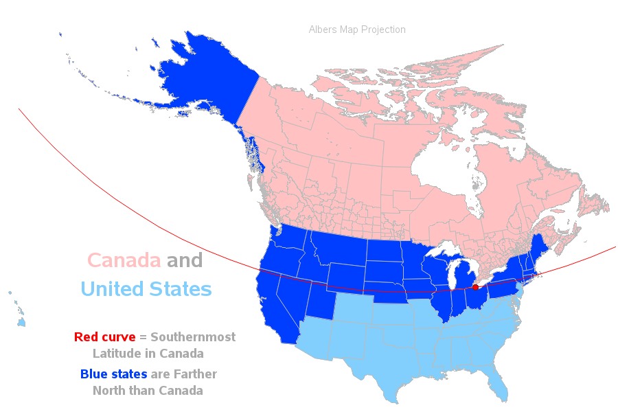
Of the 50 US states, 27 are all or partially north of Canada’s southernmost point. Map here.
EDIT: Ninja’d by wolfpup.
The OP is clearly asking for examples of parts of the United States that actually lie directly north of part of Canada, so that if you went directly south, you would at some point be in Canada.
Of course, the most prominent example is the city of Detroit, and a large number of its suburbs, much of which lies north of Windsor, Ontario.
Just from a quick glance along the border:
- The southeastern Alaska Panhandle.
- Part(?) of Point Roberts and maybe a tiny portion of the San Juan Islands.
- Some insignificant, probably unpopulated nibbles in northern Minnesota and southeast of Sault Ste. Marie.
- Eastern Michigan, east of a line roughly from Detroit up to the top of the “thumb.” This is the largest and most significant by far.
- The area around Niagara Falls, New York, including a teeny sliver of northwest Buffalo.
- Maybe one or two tiny triangles of water in the St. Lawrence River
- Some more protrusions of no consequence in New Hampshire and Maine.
There are also Rio Grande river meanders where you can go due north from US into Mexico.
I’m sorry, but how is that relevant to the OP??
Do you mean the northwest angle? Not heavily populated, but a fair size.
Well, consider that there are places in the United States where, heading south-ish, you pass through Canada on your way to Mexico.
No, there’s nowhere there that’s due north of Canada, except maybe a tiny tip of an island. I was looking at things like this empty patch.
Fair point. Although to travel by land, an Angler does need to go through Canada.
How about the whole state of Alaska?
Most of Alaska is due north of the south Pacific, with no Canada in-between. 
Not just water. The Iroquois Dam is in American territory and the Canadian border juts out just south of it.
However, there’s quite a bit of Hawaii in between Alaska and the South Pacific.
Yes, but not relevant to the OP.
True, but the OP has been answered quite well by @Lord_Feldon in post #5. That is, unless someone wants to get into the nitty-gritty of exactly what bends in various river borders result in parts of the US being north of Canada. For example, my road atlas shows two places along the Ontario-Minnesota border with that condition and there’s probably more if you expand the map and get down into the weeds, so to speak.
Not to add another irrelevancy  . But I feel compelled to point out, we often say in Michigan, that Detroit is the only place where you go due South to get to Canada (Windsor, ON).
But doesn’t Alaska kind of wind around Canada at one point?
Never mind. Carry on with the discussion .
But even excluding Alaska that isn’t even close to being true. It’s not even a unique trait within Michigan.
The land border between Quebec and the USA east of Sherbrooke has a bunch of little bits where the USA is north of Canada, as does the Maine-New Brunswick border where it follows the Croix. The Ontario-Minnesota border has bits of the USA above Canada too.
Please don’t take it on yourself to police the thread. If you think there’s a serious hijack of the thread, report the hijack. Otherwise, just ignore posts that you think are irrelevant.