So we are going to California for Spring Break – Monterey & San Francisco. We’ve been there once before, so we know a little about the area, but not a lot. My 18 year old really wants to see the San Andreas Fault, and so I thought I’d ask you guys where a good place to see it might be.
When we were there before I think we went to Hollister or San Juan Bautista or somewhere like that, but I’m not sure. The more spectacular a view, the better, of course, especially since we will have Miss Picky teen with us, but anywhere that we can stand by the Fault line would be good.
So, any recommendations of where to see it? Thanks!
Hollister is probably your best bet for dry-land, foot-straddling options. You could also take a hike on the shores of San Andreas Lake on the Penninsula south of SF. The fault is named after the lake.
You could also contact the USGS office in Menlo Park (contact info here) and ask about places to see the fault. The people I’ve met who worked there were really nice and all of them are total geology geeks.
Tomales Bay is part of the San Andreas fault as is Crystal Springs Reservoir. Neither are particularly fantastic views of the fault but can be appreciated more from an aerial view. Point Reyes next to Tomales Bay is spectacular in any case.
One of the best views is way down here north of Santa Barbara in the Carrizo Plain National Monument, Unfortunately, it’s very far away and a bitch to get to.
And if I might offer an off topic suggestion, we see a lot of tourists who think that all of California is Baywatch weather/80’s, all the time. It isn’t. Bring your jackets.
Thanks for the replies! LouiseE thanks for the advice! My husband was stationed at Fort Ord for a few months 10 years ago, so we are ready for the weather (we hope). Our kids, however, weren’t around then. The older one (age 18 and actually our niece), is definitely the type that thinks the real world is like TV. We’ve probably scared her enough now that she’s only going to pack winter clothes! <G>
Oh how I wish we had more than a week! So many places we didn’t get to see when we were out there before, and so many places we loved and want to see again.
This is what I was going to recommend. I grew up not far from Point Reyes and I’ve visited the Earthquake Trail a bunch of times. The movement of the earth is clear when you see things built over the fault line that are now split in half, with the two parts many feet away from each other now. It’s impressive even to those of us who tend to be nonchalant about earthquakes. The rest of the trail is quite short and not terrifically exciting, but Point Reyes as a whole is beautiful and certainly worth visiting at any time of year.
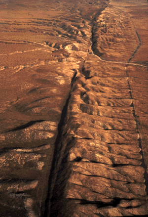
It’s too far south for your trip and you have to view it either in photos or a quick glimpse at freeways speeds, but I’ve always thought the following image a spectacular example of fault line forces. It is where the fault crosses the Antelope Valley Freeway near Palmdale, California. USGS.gov | Science for a changing world
Some where in Point Reyes park is the point of rupture for the 06 quake, which moved 18 feet, and there is a fence line right there. Or was. When flying in to the airports, you will see a long line heading up valleys, and that is evidence of the fault.
Three of my grandparents lived in California and survived the quake, one with a building falling down around her.
Pinnacles National Monument sits practically right on top of the San Andreas–but I don’t think you see the fault itself in the park. If you’ve never been there, it’s well worth a visit.
If you’re up for a full day on the road, you can swing down to check out Parkfield, the earthquake capital of California. (It’s a great time for a roadtrip in the area; the hills are green and the wildflowers are blooming all over!)
How far is it in real driving time from San Francisco to the Earthquake Trail at Point Reyes? I’d like to try to fit it in, and google maps says 1 hr, 22 min, but I wonder about traffic and such. Looks like a great place to see the Fault!
That sounds about right. I mean, you can never tell exactly how traffic is going to be, but it sounds okay. If you leave in the morning, you’ll be going against the commute, so it shouldn’t be that bad. (I’m not sure if that makes sense…what I mean is that most commuters go south, toward San Francisco, and you’d be traveling north.)
I grew up in the North Bay, so if you want, I can make some recommendations for other things to do and see in the area, although there’s certainly enough just in Point Reyes for a day. (Oh, one other thing I forgot to mention is that the ranger station at Point Reyes has a seismograph, so you can watch all the little earthquakes going on all the time.) If you have a weekend, you wouldn’t be far from Sonoma and Napa at that point, if the wine thing is appealing to you.