So imagine you pierced an orange from top to bottom with a metal straw, perfectly vertically. The holes at either end are the “top” and “bottom” of the orange. Now imagine you did that with the Earth. The line through the Earth, respective of its tilt, is its … perpendicular? At the points at the top and bottom are its … perpendicular north and perpendicular south?
Is there a map or a graph somewhere of where the Earth crosses through these points?
The Earth has an axis of rotation, which goes through the north and south poles, but you can imagine other lines going through the centre of the Earth and coming out at some arbitrary antipodal points.
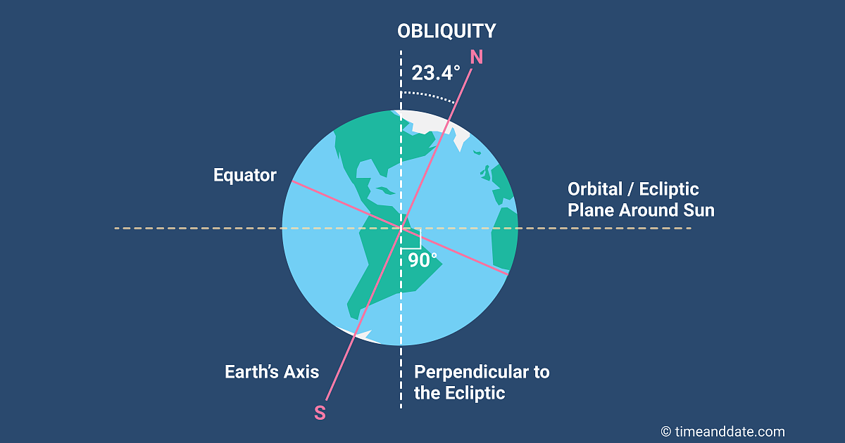
If you are asking about Earth’s axial tilt, here is a diagram showing what is going on:
So, yes, the north and south ecliptic poles do not line up with the geographic poles, possibly confusing what you want to call the “top”.
If the “top” if the most northerly point and the line is the axis of rotation the line will go from the north pole to the South Pole
If the line is going perpendicular to the Ecliptic plane around the sun then:
At the spring and autumn equinox it go frm the North Pole to the South pole
On the Summer Solstice in the Northern Hemispere it will go from the the point on the Arctic circle where the time is Solar Midnight to the Point on the Antarctic circle where it is Solar Noon
On the Summer Solstice in the Southern Hemispere it will go from the the point on the Arctic circle where the time is Solar Noon to the Point on the Antarctic circle where it is Solar Midnight
On other days it will go from a point within the Arctic Circle to a point within the Artactic circle with the longitude being based on solar noon / midnight and Latidue being 90 degrees from the latitude where the sun is directly overhead.
The image might help
Edit: Ninja’ed but I will leave this in case it adds extra clarity
I’ll ask it here rather than start a new thread, but is there any objective physical basis for picking some longitudes at the equator as the Earth’s “East” and “West” poles? Some tertiary deviation from an oblate spheroid usually only relevant to satellites’ orbits maybe?
Except it’s not there anymore. They discovered later that due to local gravity lumps, the Airy Telescope was not perfectly level. Rather than change all of the measurements they had made assuming it was, they simply moved the prime meridian.
It is due to irregularities in the Earth’s gravity field.
And later it got redefined a few hundred metres further away, and no longer sits on the line on the ground at the Greenwich observatory.
You can define a lot of different references for the Earth. Because the Earth is pear shaped and not homogeneous inside - with lumpy bits in addition to the different layers, you can define lots of incompatible centres, all reasonably sensible by themselves.
We generally use the WSG-84 geoid to describe the Earth. Even though it has 84 in the name, the year it was defined, it has been refined over the years. We now have a silly precise model. WSG-84 is defined with spherical harmonics, just as pictured above. Just a lot more orders.
Those might make geosynchronous orbits drift randomly, but I don’t see how they could favor particular longitudes unless they were resonant with the Earth’s rotation, which afaik they aren’t.
I guess the 75 degrees just shows up in the gravitational potential of the earth with the equator not being perfectly circular, in the J22 term. But if the satellite did not start at that longitude, to that degree of approximation it should oscillate around it, not just drift there, unless I’m missing something?
One wonders whether the choice of Greenwich for the Prime Meridian wasn’t also informed by the fact that it meant the bulk of the International Date Line would be out in the middle of the Pacific. It’d be an annoyance if it cut through anyplace populated, right?
Just read up on the International Meridian Conference (1884). There was a proposal to place the meridian in a place that did not go through any countries, but it was rejected. Nothing at all about the IDL, though.
The date line does not follow the meridian, though,— each country picks its own time zone— and the Meridian Conference itself refused to propose or agree to any time zones.
Yes, of course it doesn’t follow 180 straight N to S. But it’s where it is because that’s where 180 is and 180 is there because of where 0 is. Better that the date line have to avoid some minor island nations than if it were where, say, the line between Eastern and Central time is.