When going by sea from Europe, you would obviously go east to go to Africa, the Middle East, India, Indonesia and probably Australia and China. If you were going to the Americas and possibly as far west as Hawaii, you would go west. If you wanted to go to Fiji- ??? Pure geography might not be the criterion because of things like favorable winds and currents, available ports, stops for other purposes along the way, maybe the time of year, etc. And obviously the introduction of steam and the opening of the Suez and Panama canals might have made the difference for some Pacific destinations. So about where in the Pacific was the effective dividing line?
Also called, 1-900-… wait. Sorry.
[QUOTE=Lumpy]
When going by sea from Europe, you would obviously go east to go to Africa, the Middle East, India, Indonesia and probably Australia and China. If you were going to the Americas and possibly as far west as Hawaii, you would go west. If you wanted to go to Fiji- ??? Pure geography might not be the criterion because of things like favorable winds and currents, available ports, stops for other purposes along the way, maybe the time of year, etc. And obviously the introduction of steam and the opening of the Suez and Panama canals might have made the difference for some Pacific destinations. So about where in the Pacific was the effective dividing line?
[/QUOTE]
if I understand you correctly, your question has nothing to do with the international dateline. Instead, you want to find out how far to the west we can find the point where it is still faster to set out to the west and not to the east to reach it from Europe.
I have absolutely no clue.
[QUOTE=Švejk]
if I understand you correctly, your question has nothing to do with the international dateline. Instead, you want to find out how far to the west we can find the point where it is still faster to set out to the west and not to the east to reach it from Europe.
[/QUOTE]
Correct; or maybe not overall faster but in practice a ship setting out from Britain would choose an easterly course rather than a westerly, or vice-versa.
Get a globe, some string, and tacks.
[QUOTE=Lumpy]
… in practice a ship setting out from Britain would choose an easterly course rather than a westerly, or vice-versa.
[/QUOTE]
We’re talking about a sailing ship?
In high southern latitudes, prevailing winds are westerly (and often strong) which favors heading east around the Cape of Good Hope. But the fast route to that cape usually involved sailing well west in the Atlantic (often passing rather close to Brazil) - winds near the equator are notoriously fickle and it was found that the direct route along the west coast of Africa, though substantially shorter in distance, usually took longer.
Ships would use the route around Cape Horn for destinations like California and Hawaii - the large amount of distance saved made that upwind route preferable (though it could be tough).
I know the OP specifies travel by sea, but on a related matter- I asked a friend from Moscow if, when she travels home, the flight takes a westerly path or an easterly path.
I was surprised to hear that flights from Los Angeles to Moscow fly North over the Arctic.
[QUOTE=bienville]
I know the OP specifies travel by sea, but on a related matter- I asked a friend from Moscow if, when she travels home, the flight takes a westerly path or an easterly path.
I was surprised to hear that flights from Los Angeles to Moscow fly North over the Arctic.
[/QUOTE]
The great circle route from LA to Moscow passes very close to the North Pole, so that’s the way planes go. It’s only because we’re misled by the Mercator projection that we find this “surprising”.
[QUOTE=bienville]
I was surprised to hear that flights from Los Angeles to Moscow fly North over the Arctic.
[/QUOTE]
As AABE notes, if you look at a globe you wouldn’t be a bit surprised.
For Great Circle routes try this site. Enter LAX-SVO in the top box.
Check out the route from Sao Paulo (Brazil) to Melbourne (Australia), its the exact opposite, you fly pretty close to the South Pole. (enter GRU-MEL)
Yes, but you don’t sail in a great circle. (The ice tends to get in the way, or the land.)
Prevailing winds surely mean that it is not simply a matter of distance.-
[QUOTE=Colophon]
Prevailing winds surely mean that it is not simply a matter of distance.-
[/QUOTE]
Are prevailing winds important in these days of powered ships? Ocean currents, maybe.
My current job is to “route” ocean vessels around the world, to hopefully achieve the earliest arrival, while also taking into account distance (to save fuel), and weather safety.
There really is no easy answer, since the fastest route generally depends on the weather, the port rotation (departure and destination ports), type of ship (fast container ship, or slower cargo ship, etc.), and whether the vessel can or is willing to sail via the Panama Canal or Suez Canal.
At work, I can likely give rough sailing times for any given port rotation, but since I’m at home now, I can make some general guesses.
From Europe to Australia for example, it would really depend on the port rotation and whether the vessel can sail via Suez. If it can, via Suez and through the Indian Ocean is quicker. From Australia to Europe however, we would normally take vessels via Cape of Good Hope (South Africa) or Suez, depending on whether the client wants to pay Suez transit fees.
If we had to discount Suez or Panama as options (for the OP example), it may still also depend on the exact port rotation, as I’m not sure if a route from Europe to Australia would go Cape of Good Hope, or Cape Horn. I think western/southern Australia may be Cape of Good Hope, with east/northeast Australia via Cape Horn.
When I go back to work on Wednesday I can play with some numbers, if needed.
This is why I love the SDMB. Somebody asks a wacky question out of curiosity, and we have somebody in the field right at hand to answer.
OK, an update with actual numbers.
The rough, estimated sailing distances are based off a route we might recommend to an ocean vessel this time of year, taking into account prevailing weather/climatology (including ocean currents), assuming a sailing speed of about 14 knots (the speed of a fairly quick cargo ship).
From Gibraltar Strait to northeastern Australia (Haypoint):
Via Cape Horn: 13500 miles
Via Cape of Good Hope and south of Australia: 12650 miles
Based on this, it seems anywhere west of 160E longitude (give or take), via Cape of Good Hope is faster, and east of 160E, in the southern hemisphere at least, via Cape Horn is quicker. So, Australia, Papua New Guinea, and likely the Solomon Islands would be quicker via Cape of Good Hope, with New Zealand, Vanuatu, and Fiji being quicker via Cape Horn.
There are so many variables as I mentioned above, mainly the exact port rotation, and whether vessel will sail via Panama or Suez, it’s difficult to list all the possibilities. However, if the OP would like a particular journey (or even a list), I’d be happy to crunch the numbers.
(edit) Updated distances.
Out of curiosity, how much would Suez and Panama cut off of those Gibraltar/Haypont distances? Assuming the ship can transit either canal, would the dividing line move much?
[QUOTE=Billdo]
Out of curiosity, how much would Suez and Panama cut off of those Gibraltar/Haypont distances? Assuming the ship can transit either canal, would the dividing line move much?
[/QUOTE]
Via Suez, the distance drops to 10270 miles (there are several different ways to go from Suez to Haypoint, but via Singapore and Torres Strait seems to be the shortest at rough guess). Via Panama the distance is about 12450 miles.
I messed up yesterday, it seems the dividing line would be around 140E perhaps, with eastern/southern Australia and Papua New Guinea (and anything farther east) being quicker via Cape Horn, and anything farther west being quicker via Cape of Good Hope. If the canals are available, the dividing line may be around 160E (as I mentioned yesterday).
I thought of this old thread when I found a recent article on Gizmodo about global travel times. Here is the map for travel times from London circa 1914:
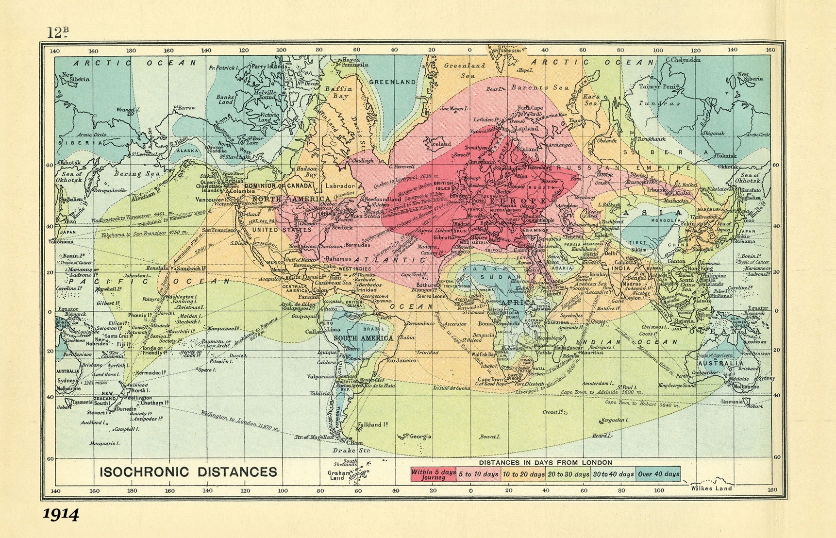
Hard to tell exactly because the area of interest- 140°-160° E -is on the edges of the map, but it gives a general idea.
ETA: I presume that it includes disembarking and traveling across land by rail (hence it’s much faster to get to California than Chile) but for Pacific destinations it probably doesn’t make much difference.
Now that’s an interesting map! Earth as perceived by the late-colonial British mind. Note that “darkest Africa” is geographically pretty close by, but temporally it’s as far as Australia.
If wish I could use some sort of fancy image-processing software to distort the map so that the isochronic areas would become circles.