What is the reason that the US border doesn’t entirely follow the St. Lawrence River from Lake Ontario to the Gulf? Why does it go inland at Cornwall? And why did Quebec get that little strip of land that vaguely looks like a penis?
Is there a real reason New Brunswick, Nova Scotia and the penis strip aren’t part of the US?
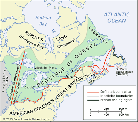
That area was settled by the French, and was part of New France until it was ceded to the British in 1763. It subsequently remained part of Canada under British rule.
In general, but there were still some unsettled borders on the south side of the Saint Lawrence. The northern border of Maine was settled following the Aroostook War (actually just a face off between local militias who did not actually engage in combat). Vermont’s situation resulted in it governing itself as The Republic of Vermont for 14 years during and following the Revolution.
For the same sort of reason that the Rio Grande eventually leaves the border of the US and Mexico, and why the Mississippi flows substantially inside the borders of Minnesota and Louisiana. The border as the river was convenient and meaningful at some points, but at other points it just no longer worked due to the geopolitical realities of the situation.
(Minor pedantic note: the Mississippi does flow into other states that it mostly forms the border for, as its course has changed in some places since the boundaries were set.)
The short answer is Montreal and Quebec City. If the border were to run along the Saint Lawrence, then parts of these cities (or at least their metropolitan areas) would be in the US, and that was considered undesirable. So, they moved the border south a bit.
This really had nothing to do with it. Although today both cities are large and their metropolitan areas extend to both sides of the St. Lawrence, in 1763 the main area of settlement in both was confined to the north side of the river. The reason is that there was French settlement on both sides of the river in this area.
I apologize for being unclear, but Montreal and Quebec have everything to do with it. The border was placed where it was to create a buffer zone. No one there wanted the US to be as close as just the other side of the river.
Cite? Please provide some historical support for you assertion.
The border was created long before the US ever existed. I don’t know why you keep mentioning the US as if it had something to do with it. The boundary was first between French and British possessions; then, after the French claims had been ceded to Britain, between separate entities within the British North American colonies.
Montreal is on the island, but the French had settled all over the area. the border just recognized the best compromise between the British-controlled areas and the rebellious colonies. Ditto for Nova Scotia nd New Brunswick - colonies that did not have as much of the background and history of grievances that would make them want to rebel, so they didn’t. The colonies still held uncontested by the British, they kept. the ones that rebelled, they didn’t.
If you look at the satellite images, the line marks roughly the end of flat St. Lawrence valley farmlands and the beginning of the wooded Appalachian mountain area that in the 1700’s was not yet settled. Like most such European agreements over remote sites, a straight line was the simplest. When it hits the watershed divide between the Maine and St. Lawrence/ New Brunswick watersheds, it follows that route… except it seems there are a few spots where they gave up surveying and decided on straight lines there, too.
This border was not created before the US existed. The part of the US-Canadian border east of the Lake of the Woods was decided in the Treaty of Paris. Disputes caused by poor geographical knowledge led to other treaties later on, including the Webster–Ashburton Treaty of 1842, which settled the boundary of Maine, among other things.
As far as Quebec goes, the British made a better deal with them than they could have obtained from the USA, through which they preserved their religion, civil law and seigneurial system (the latter not a particularly good thing over the long term, but it was their thing).
Their economy was based on the fur trade, so the British expanded Quebec’s territory to include Labrador on the Atlantic all the was west to the junction of the Ohio and Mississippi rivers and all the way north to Rupert’s Land. By maintaining the territory on the south shore of the St. Lawrence, the traditional fur trade routes for the Atlantic watershed were secured for Quebec.
That was a sweet deal for Quebec. The Americans didn’t have anything comparable to bring to the table.
The original colonization followed the water. There were settlements in the Saint Lawrence River valley and settlements along the Atlantic coast. The border was placed inland between the two main population areas in what was then unsettled (by Europeans) territory.
Demographically, the British had relatively recently booted most of the Acadiens out of Nova Scotia, which at the time included what is now New Brunswick, and increased settlement by people from Scotland, who were rather clannish and did not have ties with the Yankees.
Politically, Nova Scotia already had representative government through a popularly elected assembly, albeit still subject to the Crown. Prior to the American Revolution, Nova Scotia was in the process of making reforms to deal with balancing the legislative, judicial and executive branches of government, as well as dealing with patronage and taxation.
Economically, Nova Scotia’s Halifax was the base of the British Atlantic Station and the Royal Naval Dockyard, and where trade with Britain was tremendously important. The rest of the region was sparsely populated, and for the most part poorly connected except by water, which made it somewhat economically isolated from the colonies that revolted.
Although opposition to the American revolution was by not means monolithc given than many people in Nova Scotia had roots in the Yankee colonies, the demographic, political and economic factors weighed on on staying with the Crown. Whatever chance the Yankee colonies had to sway over Nova Scotia were burned when their raiders repeatedly attacked Nova Scotia from the outset of the American revolution.
Of course it was. The boundary recognized by the Treaty of Paris for the most part followed the previous boundaries between Canada and the other British colonies. The boundaries of New York, New Hampshire, and Maine (then part of Massachusetts) had never been recognized as running up to the St. Lawrence.
Just one example in support of Colibri: Lévis is a town on the south bank of the St Lawrence just opposite Quebec City. It had always been part of the colony of Quebec prior to the US rebellion, not part of Massachussets (which Maine originally was).
#/media/File:North_America_1748.PNG)