Teterboro Airport, takes up most of Teterboro, NJ and also extends into Moonachie and Hasbrouck Hights.
Dov Hoz airport is actually well within Tel Aviv, very close to residential housing. It mostly serves domestic flights to Eilat but has limited international service as well.
I’ve never heard this claimed nor seen a map that shows Seattle extending that far south, and wiki disagrees as well. Where did you hear that it’s in Seattle?
Not to disparage the accuracy of wikipedia but
The address: 17801 International Blvd, Seattle as per Port of Seattle
I recall seeing a map online that had the city limits of Seattle following the 99 down to the airport.
I did send the question to the Port of Seattle to get a definitive answer.
Not to nitpick, but I think that’s stretching the definition of “within a city” just a bit. To the extent that Teterboro is part of the New York megalopolis, then maybe, but I wouldn’t call Teterboro itself a city. Boroughs in northern New Jersey are very small and it’s especially unlikely anyone would recognize Teterboro (pop. 67) as a city. Almost all of the borough is Teterboro Airport.
Ninoy Aquino International Airport, Centennial Domestic Terminal and Terminal 3 ( The new Airport) are all in Manila City.
Technically, Narita International Airport is inside the city limits. City of Narita, that is.
Des Moines (DSM) picked the site for its airport in 1932 when it was a good 3 or 4 miles out of town. About the only thing nearby was newspaper publisher Gardner Cowles’ house. He and his wife Fleur had people routinely turn down dinner invites because it was too far to drive.
In the 50s and 60s Des Moines grew around its airport and the route to it from downtown became Fleur Drive (named for guess who).
Quoth John Mace:
Then again, though, Philadelphia also lacks skyscrapers, and still manages to feel like a “real city” and a “real downtown”.
Wiki’s tallest buildings list for Philadelphia lists 27, which are all too tall for downtown San Jose:
Their list cuts off at 400 feet. as noted, the San Jose limit is under 300 feet. San Jose’s tallest:
I think you downplay Philadelphia a bit…
Philly isn’t Manhattan, and certainly wouldn’t be mistaken for San Jose, which other than the hills/mountains on two of its sides, might easily be confused with Schaumburg, IL.
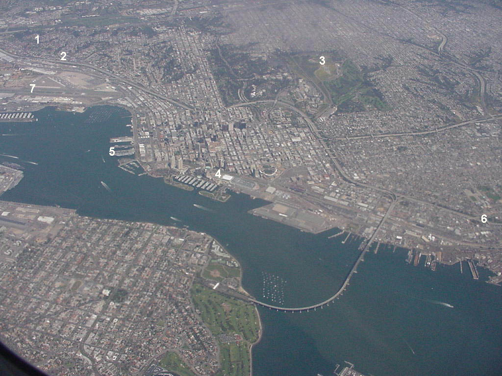
This is what you see coming in for a landing at San Diego International:
http://online.recordnet.com/projects/blog/2008/0325Flight_003.JPG
Here is an overhead shot; the airport has a number “7” on it (on the left), the downtown (high rise) area of San Diego is just above the “4”:
McCarran International is right smack in the middle of Las Vegas. map here
Thinking it over, it’s actually about 6 miles from downtown to the airport (downtown stops at the Raccoon River and always did).
Actually, that map proves nothing. According to it, McCarran might be in the city of Las Vegas, or it might not. Like so many urban/suburban areas, the core city limits are a lot smaller than the built-up area.
This map http://major.lasvegasnevada.gov/website/clvcamps/viewer.htm from the city government clearly shows that Mccarran is a couple of miles outside the city limits.
A large fraction of the built-up area in the greater Las Vegas valley is unincorporated county land.
In fact, most of the famous part of “The Strip” is outside the city limits of Las Vegas proper.
I lived in Vegas for many years. In fact the Strip was developed outside the city limits precisely to avoid city taxes & regulations.
Capital City Airport, located within the city of Lansing, Michigan.
Long Beach Airport, well within the city of Long Beach, California - which not only encloses the airport, but also completely encloses the city of Signal Hill.
they moved Chicago.