You read this about many cities in the world: That they were founded at their respective places because the coastline there forms a “good natural harbor,” making the position ideal to establish a port there. But what exactly constitutes a coastal formation an ideal harbor? Usually it’s described as some sort of bay or long-stretched strait, surrounded at as many sides as possible by land so ships anchored there would be protected against “the wheather;” but wouldn’t waves created by a storm ravaging along the shore enter the bay nonetheless, damaging ships just as much as if they had been anchored on the open sea? Besides, a number of cities praised for their natural harbors are situated on the inner side of bays, but rather open bays which do not offer much protection against the open sea. So what did sailors searching for a place to found a port look for?
A good natural harbor is deep enough (vertically) for the desired ships, has no obstructions or underwater hazards, and is big enough (horizontally) to handle the desired traffic. It should have a shore that ships can connect to, tie up and on/offload (gentle sand beaches aren’t too good but neither are tall straight clifs).
A breakwater or a turn in the water route will reduce the wave action inside the harbor. Waves don’t go around corners well and waves are murder on docked boats.
A small harbor was built near me not long ago by a guy who wanted to shelter his two boats (mini-yacht sized). He blasted out the rock, but forgot that he was on a point of land, not a natural harbor. On points of land, the waves will hit from all sides. Just making a depression in the rock doesn’t keep them from battering boats, and sure enough, he lost two boats one stormy day. The waves battered the anchored boats to pieces, even in the harbor.
Any decent marine engineer could have told him his harbor was a bad design.
The mouth of a large river is often good. Turns in the river reduce the wave action from the sea and there are typically many places to anchor or dock.
There are a number of features. You need good depth of water in an inlet with a closed (not completely, of course) entrance that does not permit much entry of waves. You need ideally an approach that does not involve crossing a bar. Another good feature is a shoreline that is “steep to” in other words where the bottom drops away quickly so that it is deep close to shore (ie not mudflats or shelving sand requiring long jetties to reach deep water).
The better natural harbour it is, the less storm waves will enter. Pretty much by definition, it isn’t a good natural harbour if the prevailing weather will cause swell in the harbour. Stretching it slightly, you do hear harbours described as “good natural harbours except in strong SE conditions” (for example) which probably means there is an SE entrance which permits bad weather to enter from that direction. If SE conditions are unusual or have only a limited season (say) it still might be a good harbour. Bays that are open are generally not good natural harbours. What cities are on “good natural harbours” that are open bays?
Rivers can be OK but tend to have bars at their mouth. They tend either to have limited draft or need dredging.
[QUOTE=Schnitte]
“the wheather;”
[/QUOTE]
Or, you know, not.
The water needs to be deep enough close to land to allow fully loaded ships to dock at the end of a pier, and as Musicat said, the water needs to be sheltered from the open ocean and any large waves.
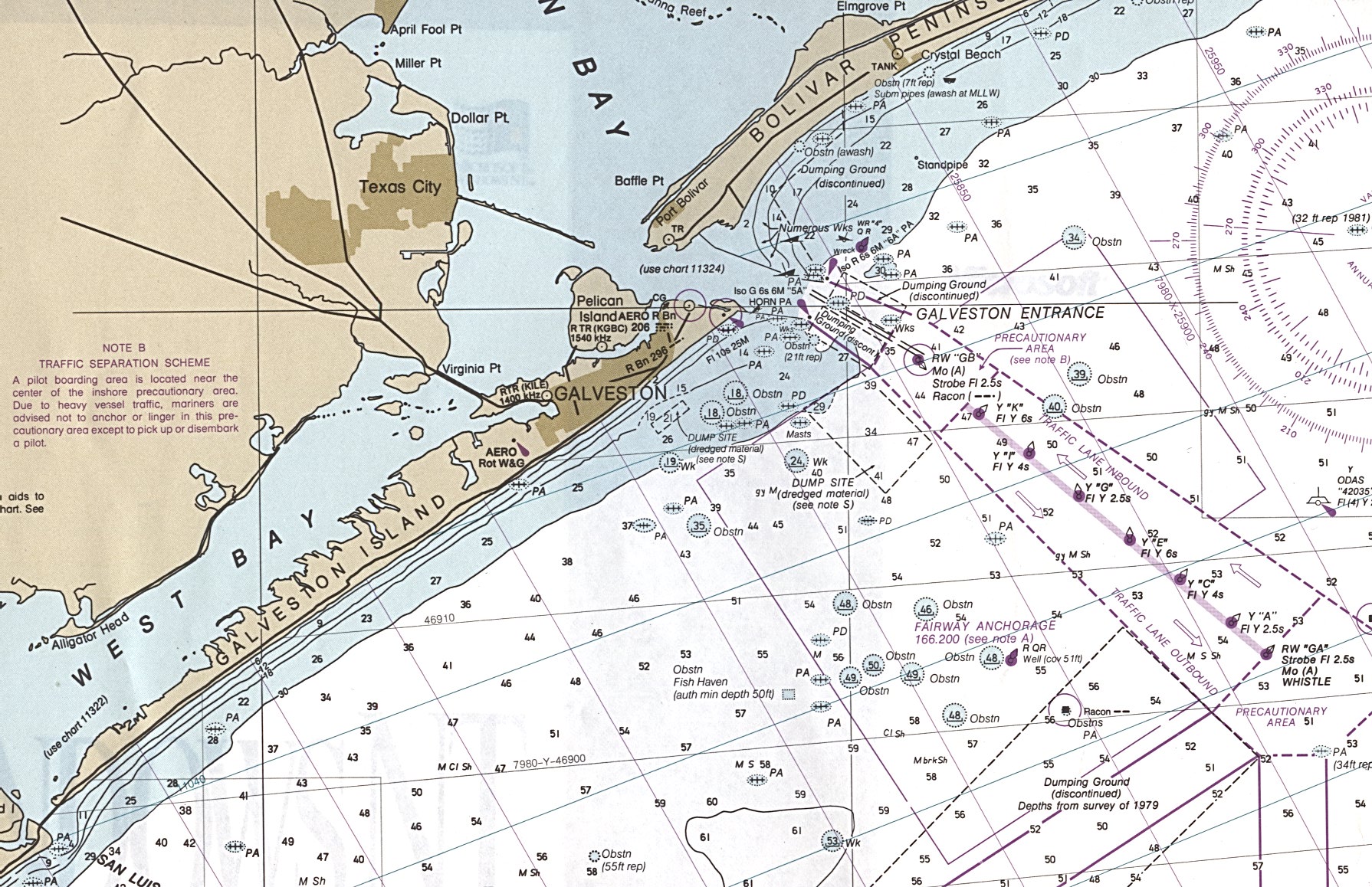
I grew up in Galveston, Texas, which is a good natural harbor. The Texas Gulf Coast is incredibly flat and the waters near it are shallow. The larger bays can have an average depth of six feet or less.
Galveston works because Galveston Bay is large and has only three outlets to the Gulf of Mexico. Back before they started dredging, the tidal action dredged Bolivar Pass to an acceptable depth, and the water passing between Galveston and Pelican Islands kept the bay deep enough behind Galveston Island. The island itself meant that the harbor was in the lee of winds and waves coming in off the Gulf.
St. John’s, the capital of Newfoundland and Labrador, has an excellent natural harbour. It’s got a narrow entrance, and then curves immediately, so that even if waves make it in the entrance, they don’t go up the entire harbour. The far western end is pretty much dead calm.
As well, it’s surrounded by high hills, so there’s a natural windbreak on all sides. The rule of thumb for coastlines is that the higher the surrounding terrain, the deeper the water, and that’s the case here as well - deep water right up to the edge of the land.
Here’s a shot of the harbour looking east, towards the entrance, and another shot looking west, from Signal Hill above the entrance.
…
By contrast, look at the pictures of Trinity Bay, also in Newfoundland, at the top of this page. It’s a huge bay, with some shelter from the North Atlantic, but it’s more open to the weather and with a broader, less sheltered entrance. Trinity Bay was the first bay used by the English fishermen and the Royal Navy, but they gradually shifted operations to St. John’s, because the harbour there provided better shelter from the North Atlantic weather.
I’ve been in St. John’s when it got the tail end of a hurricane that worked its way up the eastern seaboard. It was terrible weather to be outside the harbour, with extremely high winds and waves. Inside the harbour, there was terrific rain, but the wind wasn’t very bad at all down on the waterfront, and the water was just choppy, not dangerous.
So Mrs. Piper and a friend and I just found shelter in a 3 century old stone inn, with a natural fire, and ate lobster while Newfoundland music played and the rain beat against the windows. One of our best evenings ever!
To address the OP’s implicit question about how storms create wave action: There are, AIUI, two methods by which wind effects create water effects. The first is the storm surge where, basically, a strong storm system is pushing water ahead of it, causing a rise in the water levels in coastal areas. And, AFAIK, the OP is correct that this will not be stopped by the effects of breakwaters, or sheltering islands. But a storm surge is also a relatively gentle phenomenon. There are cases of storm surges occuring in areas that are later missed by the storm, itself, and the damage there is relatively minor - simply some flooding in low-lying areas, and none of the wind and water battering that one would expect from a rise of several meters in sea level.
The other effect is that winds will whip up waves as they blow over open waters. This is a much more damaging phenomenon, it’s what creates the crest and trough wave cycles, and in open water a powerful storm can set up wave action where the waves are 10 meters, or more, between the crest and the trough. When these hit land, or anchored vessels, it’s like being slammed by tons of water moving at speed. (For some silly reason.) A breakwater, or shield island, will do a lot to restrict the force of such waves entering the anchorage. In effect, the full fury of the storm’s waves will be broken on the breakwater, and the wind will have to start building up the crests again inside the harbor. And it takes time, and distance, for a powerful wind to drive large waves.
This time and distance factor is one major reason why the storms on the various Great Lakes have such different effects in terms of wave action and power. Lake Erie, for example, is narrow, oriented almost perpendicular to the prevailing wind directions, and very shallow. All this combines to make storm waves over a meter very, very rare. Lakes Michigan and Ontario can get up to two meter swells, which are much more destructive, but it’s really only on Lake Superior that the wind has the alignment and the distance to really whip up good storm swells.
[QUOTE=OtakuLoki]
This time and distance factor is one major reason why the storms on the various Great Lakes have such different effects in terms of wave action and power. Lake Erie, for example, is narrow, oriented almost perpendicular to the prevailing wind directions, and very shallow. All this combines to make storm waves over a meter very, very rare. Lakes Michigan and Ontario can get up to two meter swells, which are much more destructive, but it’s really only on Lake Superior that the wind has the alignment and the distance to really whip up good storm swells.
[/QUOTE]
I think you are underestimating the waves in both Erie and Michigan. Also, Lake Erie can be subject to seiches, where one end of the lake’s nominal level is higher than the other. This happens most when the wind blows in the same direction as the lake is long. Water is pushed to one end, and there are waves on top of that surge.
This doesn’t seem to happen much in Lake Michigan, as the winds are rarely north-south or vice-versa. But I can attest to 6 meter waves on Lake Michigan during some violent storms, as reported by mid-lake buoys:
Note: these buoys are not active in winter, and are typically replaced sometime in April.
I have also observed wave heights, as reported by those buoys, at 255 ft, but my guess it that was an error of the reporting electronics, not a valid observation, since if it really was a 255-ft wave, my house would be under at least 230 feet of water, and I would have noticed the increased dampness. ![]()
[QUOTE=Derleth]
Or, you know, not.
[/QUOTE]
OK, I got it, an h too much.
[QUOTE=Princhester]
What cities are on “good natural harbours” that are open bays?
[/quote]
My impression from this map is that Cape Town is situated at a bay with a rather open mouth. I guess the city should have a good harbor, since it was intentionally founded as a trading post.
Thanks anybody for their input. I was interested in this question because, as I stated in the original post, you read about the harbor as the primary reason for the foundation of a city in so many cases that this matter seems to have had some impact on the course of history.
Looking at Cape Town on Google Earth, it would clearly have been a crap natural harbour in NW conditions. It has been improved with extensive sea walls presumably to make it a good artificial harbour.
One look at San Francisco Bay says it all. 
When Admiral Perry came over to Japan to force Japan to open up to the West, one of the demands was for a port with a good harbor, and near Tokyo. (Called Edo at the time.)
While well protected from the open seas, Tokyo bay itself was too shallow for ocean-going ships, and so Yokohama with it’s deeper watch was agreed on.
You can see from google maps on the position of the bay, which made it ideal. The US Navy base is in Yokosuka, another deepwater bay, and closer to the ocean, which is an advantage for a navy base, but would be a disadvantage for merchant ships.
Hong Kong was chosen by the British because it also offered a deep-water port on the inner side of an island, giving it protection from storms and ready access to the ocean.
You can have the best marine conditions in the world, but if you don’t have a reasonable terrain, quantity and quality, to allow for transshipping, the site will not qualify as a “good natural harbour”. (In a commercial sense)
Proximity to the shipping destination or source of materials has always been a major factor. The one-time largest (busiest) port on the east coast of the USA, at Marblehead, Massachusetts, can be seen, along with Salem Harbor, at
That was 300 years ago, when fishermen sailed from the town to fish on the Grand Banks. Today, you can zoom in and see all the recreational boats that moor there. It is susceptible to Northeast storms, that can roll right up the harbor. Residents of the Town voted against local and federal funding to build a breakwater 30 or so years ago. The Frigate USS Constitution, Old Ironsides, sought protection from the British ship Endymion in her harbor and visited the Town again in 1996 for the first trip out of Boston in several decades. I lived there for many years, BTW.
I later (40 years ago) spent two years on board the flagship of the US Sixth (Mediterranean) Fleet while it was homeported at Villefranche-sur-Mer, next to Nice, France, in the second most beautiful, and even more protected harbor. This can be seen at
One of the greatest natural harbors in the world is the Port of New York.
Coming in from the ocean, in the lower right, you pass between Sandy Hook (the long peninsula extending northwards from Highlands, New Jersey) and Breezy Point, Brooklyn to get into Lower New York bay. The Lower Bay is, of course, open to the southeast, but protected from other directions.
However, from the Lower Bay you can turn north and pass through the Narrows between Staten Island and Brooklyn, now spanned by the Verrazano-Narrows Bridge, to get to Upper New York Bay (more commonly known as New York Harbor. Once you’ve passed through the Narrows, you’re pretty well protected from all directions, as any southeast weather that comes through won’t be able to get through the north-south Narrows. Pretty much all of Manhattan and Brooklyn north of the Narrows is fully protected and suitable for docks. There’s also Port Elizabeth and Port Newark in New Jersey, as well as most of Staten Island.
In addition there’s the Hudson, navigable by large vessels north to Albany (and by very small ones up to the Great Lakes by the New York State barge canal system, including the famous Erie Canal), and the East River, which connects to Long Island Sound, with access to the Connecticut, Rhode Island and southern Massachusetts coasts (and through the Cape Cod canal, to Boston and points north).
All in all, it’s an incredibly well protected system of waterways, and its strength as a natural harbor with water connections to the coast and interior of the country is a reason it became such a commercial capital.
[QUOTE=Schnitte]
So what did sailors searching for a place to found a port look for?
[/QUOTE]
If you really want to know, I can’t think of a better way than to sit down with Google Earth, a map of prevailing winds, and the list of Large Natural Harbors on the bottom of this wiki page
Bear in mind that sometimes even a pretty crap harbour can be just what you need.
Torbay, for instance, is totally exposed to any easterly gale, and in fact makes for a pretty nasty lee shore in that circumstance. However, by far the most common problem in those regions is a south-westerly gale, for which the bay provides excellent shelter. During the Napolonic wars, the english fleet would just snuggle up to the French coast if there was an easterly, and run for Torbay in the event of a sou-wester.
[QUOTE=Princhester]
Rivers can be OK but tend to have bars at their mouth. They tend either to have limited draft or need dredging.
[/QUOTE]
True, but rivers give another important natural advantage: access to the hinterland.
One other nice thing to have in a natural harbor: warm enough weather that it’s usable all year, or at least most of the year, without the water freezing solid. That’s been Russia’s difficulty for a long time.
Wouldn’t a good natural harbor also have to have a ready supply of potable water?