The Compass

So one day I’m playing with a compass like the ones you find in a box of cracker jacks. I’m turning the compass back and forth amaized how the needle always points north. The outside moves and the inside stays still … what if the poles don’t move and its just the earths crust that slides over the magma? And the Ice Caps are stationary on the Crust but if something can move the crust or the crust just moves to say a position like we see above. Then the icecaps we know today would have to form over Africa and peru like on this compass for example and the one we know today would melt away. The pole never shifted it’s the crust! Or is it?
Look at the compass, If you push the compass with your finger from any direction you move the compass example if you push from north it will move south or from east it will move west. But if you Hit it from North to say East it spun I didn’t move it I just spun it The arrow stayed still the compass case or crust moved and liquid I didn’t know if it stood still or moved.

SO I dug out one of those water ball things and shook it up got the flecks going and turned it slowly and sure enough the flecks in the water did not move with the outer glass (crust). Now I imagined The tree and santa as a free floating magnet and the base as an ice cap. When I turn the globe the icecap moves with the glass crust the Magnetic pole and the magma stay put and the icecap would melt and a new on formed wherever north and south poles are pointed. Now who’s going to swallow that? Not me I wouldn’t believe that.
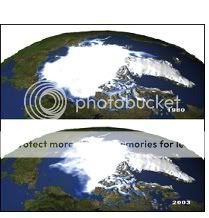
I tried to get a handle on the ice age so I looked at a map and after looking at it for a few minutes something became abundantly obvious to me. There was no ice age! Well not in a global cooling sense. If you examine figure 1 below you can picture a beret on a head sideways. The ice is too far south in the US and Covers England deep into Europe. But oddly Alaska and Siberia are Glacier free how does that work? The coldest land mass outside of Antarctica, Siberia is Glacier free? So I stuck a dot roughly in the center of the Icecap where the North Pole would have to be, just in central Greenland. The earth would have to have been on this axis to be in the center of the Polar ice cap and still have Alaska and Siberia glacier free. And sometime around 5000 years ago the “ice age ended” when the earth relocated to its present north location. It just made no sense to have one side of the planet with an ice cap and the other ice free spinning on the North Pole we have today. As seen in figure 2 below it’s just lop sided. On the Temperature map for February Month in the Northern Hemisphere you can see the horizontal temperature lines are fairly consistent east to west and the coldest by far is Siberia you would think you would get a glacier covering the entire blue cold areas. A glacier just covering the red area makes absolutely no sense at all. If it’s going to cool off it going to cool off globally not just over North America and Europe. But what if we just moved the North Pole south to the center of Greenland? Now we can freeze Europe and North America and still have Siberia and Alaska Glacier free. But the pear shaped glacier is not possible!
Figure 1 Figure 2
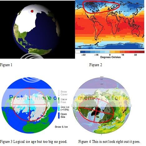
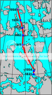
Figure 3 Logical ice age but too big no good. Figure 4 this is not look right out it goes.
Figure 3 shows the normal snowfall radius for the Northern Hemisphere if it got colder you would expect to see an ice cap this size and shape extending down to Southern United States and covering Russia 5500 km in all directions. It makes no sense to have the ice advance some 5500 km on the western hemisphere and not even reach the coast of Siberia in the Eastern Hemisphere with the North Pole at its current location as figure 4 shows. I’m not saying it was not colder at that time but the earth could not have been in its current location and have an ice cap shaped like that. If it went down 5500 km on one side it would have to go down on all sides to roughly the same degree. The ice cap went almost to the tropic of Cancer in the western hemisphere so likewise you would expect to see the same in the Southern Hemisphere.
Canada was nearly completely covered by ice, as well as the northern part of the USA, both blanketed by the huge Laurentide ice sheet. Alaska remained mostly ice free due to arid climate conditions. Local glaciations existed in the Rocky Mountains and the Cordilleran ice sheet and as ice fields and ice caps in the Sierra Nevada in northern California. In Britain, mainland Europe, and northwestern Asia, the Scandinavian ice sheet once again reached the northern parts of the British Isles, Germany, Poland, and Russia, extending as far east as the Taimyr Peninsula in western Siberia. Maximum extent of western Siberian glaciation was approximately 18,000 to 17,000 BP and thus later than in Europe (22,000–18,000 BP). Northeastern Siberia was not covered by a continental-scale ice sheet. Instead, large, but restricted, ice field complexes covered mountain ranges within northeast Siberia, including the Kamchatka-Koryak Mountains.
The Arctic Ocean between the huge ice sheets of America and Eurasia was not frozen throughout, but like today probably was only covered by relatively shallow ice, subject to seasonal changes and riddled with icebergs calving from the surrounding ice sheets. According to the sediment composition retrieved from deep-sea cores there must even have been times of seasonally open waters. How is it possible to have an ice age and not have the Arctic Ocean freeze? The ice was said to be three miles thick! The whole theory is full of holes.
Outside the main ice sheets, widespread glaciation occurred on the Alps-Himalaya mountain chain. In contrast to the earlier glacial stages, the Würm glaciation was composed of smaller ice caps and mostly confined to valley glaciers, sending glacial lobes into the Alpine. To the east the Caucasus and the mountains of Turkey and Iran were capped by local ice fields or small ice sheets. In the Himalaya and the Tibetan Plateau, glaciers advanced considerably, particularly between 47,000–27,000 BP and in contrast to the widespread contemporaneous warming elsewhere. The formation of a contiguous ice sheet on the Tibetan Plateau is controversial.
Other areas of the Northern Hemisphere did not bear extensive ice sheets but local glaciers in high areas. Parts of Taiwan for example were repeatedly glaciated between 44,250 and 10,680 BP as well as the Japanese Alps. In both areas maximum glacier advance occurred between 60,000 and 30,000 BP (starting roughly during the Toba catastrophe). To a still lesser extent glaciers existed in Africa, for example in the High Atlas, the mountains of Morocco, the Mount Atakor massif in southern Algeria, and several mountains in Ethiopia. In the Southern Hemisphere, an ice cap of several hundred square kilometers was present on the east African mountains in the Kilimanjaro Massif, Mount Kenya and the Ruwenzori Mountains, still bearing remnants of glaciers today.
Lots of theories and I concluded they are all correct. The ice age started around 60,000 years ago and 47,000 years ago and 22,000 years ago and 17,000 years ago and how is that possible? I got the start at between 60,000 and 40,000 years ago what can rock the planet? Earth quake not big enough… A meteor why not?
Look at these 2 photos of the current arctic ice cap it is getting smaller. By the looks of it we got a leak of warm water coming up from the Bearing Straight melting the west side of it. And it looks to be expanding on the east side towards Russia and Europe. (Going to get colder in Europe and warmer here in North America sometime soon) Or is the earth still wobbling from the last hit? But at any rate my point here is look at the map and what becomes glaringly obvious is Greenland it sticks out like a sore thumb here. It’s buried in a glacier and is as far south as the southern tip of Baffin Island now look at the Islands in Northwesternern Canada no glacier covering them well not to the extent they cover Greenland and they are surrounded by Glacier.
Look at figure four. With the cross hairs on Greenland where I think the North Pole was located in the last ice age if you look at the glaciers on Greenland and the surrounding area today. Look carefully and they form a ring around the North Pole.
Figure 5 shows the current Ice Cap in White and the extent of the Glacier in the last ice age in the red crosshair. After staring at the map for a few hours trying to figure out why there is an egg shaped ice cap it came to me. The polar cap had to be constantly moving. Glaciers are showing up at different times at different places. Much like one of those punching bags when you punch it the bag moves but returns to its original position. Like a weeble wobbles but it don’t fall down. But what got it moving? Did something hit the earth or pass too close or is this just a very slow natural wobble the earth is in all the time and the red zone of maximum glaciations just the path it has always followed? The latest dates I have are 60,000 to 40,000 years ago I’ll check and see if anything hit us back then. You have to like Wikipedia.
A meteor hits Arizona bingo; the crater was created about 50,000 years ago during the Pleistocene epoch when the local climate on the Colorado Plateau was much cooler and damper. At the time, the area was open grassland dotted with woodlands inhabited by woolly mammoths and giant ground sloths. It was probably not inhabited by humans; the earliest confirmed record of human habitation in the Americas dates from long after this impact.
The object that excavated the crater was a nickel-iron meteorite about 50 meters (54 yards) across, which impacted the plain at a speed of several kilometers per second. The speed of the impact has been a subject of some debate. Modeling initially suggested that the meteorite struck at a speed of up to 20 kilometers per second (45,000 mph),
Now we have a catalyst at the right time is that enough energy to start the wobble? A man is space is weightless so if two astronauts were side by side and one pushed the other they would both go in opposite directions. Now suppose one of the astronauts gets hit in the head by a little asteroid and his head doesn’t get ripped off he is going to start spinning back to front like a wind mill propeller. Even though the meteor was the size of a grain of sand and the astronaut weighs many millions of times more. So it stands to reason that the earth is weightless in space and if a meteor hits it it’s going to spin it somewhat kind a like a marble in a weightless environment. I tried a balloon with a paperclip in a bathtub and threw grains of sand at it. And yes it moved but it was the way it moved that got me thinking. On impact it moved then it slowed and slowed finally stopping just for a second then moved faster and faster to the opposite direction then slowing and stopping and moving back north again but not as far as the last time until finally it settled down.
Now suppose that the magnetic north pole is not wandering at all! What if the earths crust is doing all the wandering…? What if the earth’s crust is moving and the core is not? Much like a balloon full of water or a plastic water bottle full of water if you turned it slowly 180 deg. The water goes nowhere just the plastic. Look at the pole wandering above. Again I say that the pole has not shifted the earth has shifted above it. And where ever magnetic north pole is on the planet that is the dead center of the polar icecap at any given time. See in 1831 to 1904 that is the directional shift the earth’s crust is going southward in Canada and Europe is heading north and looks to be accelerating. Hmmm What if we here in northamerica are recording high trmps and and calling it global warming and Europe is getting colder an just think it’s a bad winter? And weather patterns are changing because places are moving to places they never were before. And what if its so slight we notice the weather change but just keep moving the magnetic north pole to accomodate the shifting crust?
Meteor hits Arizona 50, 000 years ago knocks the pole off center and spins the crust say 35-40 degrees. (Not the whole planet) that’s going to cause a major shock wave. (Kind of like getting a kick in the guts and farting… what a (Toba) Catastrophe) The new North Pole is centered over around the center of Sweden. Now we still have the same sized polar cap as we do today now it’s on a moving crust trying to get back to its natural position reaches Churchill Falls, Manitoba, Canada around some 30,000 years later and take it 15,000 years or so to get back home. So you would expect to find evidence of a polar shift along the green line in the center of the map.
Based on his own research, Hapgood argued that each polar shift took approximately 5,000 years, followed by 20,000- to 30,000-year periods with no polar movements. (But again the poles didn’t shift the earth over the poles moved.) Also, in his calculations, the area of movement never covered more than 40 degrees. Hapgood’s examples of recent locations for the North Pole include Hudson Bay (60˚N, 73˚W) , the Atlantic Ocean between Iceland and Norway (72˚N, 10˚E) and Yukon (63˚N, 135˚W).
However, in his subsequent work The Path of the Pole (Perhaps Path of the Earth would have been more appropriate), Hapgood conceded Einstein’s theory’s point that the weight of the polar ice would be insufficient to bring about a polar shift. Instead, Hapgood argued that the forces that caused the shifts in the crust must be located below the surface. He had no satisfactory explanation for how this could occur. (Hapgood had the right idea but he thought that if the ice got too thick the planet would get top heave and roll over so to speak, But with ice caps at both ends this is not possible they balance each other. Hapgood knew something didn’t look right or feel right so it was not right but what was it?) Then I found a compass, I would suggest the Arizona meteor hit would give Hapgood his movement and Einstein sufficient force and me an pear shaped glacial event. To tell the truth I have no idea about very much as I said I am an uneducated man so when I first wrote this a few days ago I threw it away because I mean really Hapgood could not figure it out Einstein missed it and all of earth science missed it but “I” got it figured out? Yup ok, they should be coming for me with the nice white shirts with the long sleves that tie in the back… But to me it just was not right! (they both knew something was off but neither knew what it was and so concluded incorrectly that it wasn’t possible) So I said to myself piss on it I’ll write it put it out there and who cares what happens at least I had a kick at the cat. Not like any reputation to worry about not like I’m a university professor and I say that there is no global warming just movement in the earth’s crust. Who’s going to listen to me anyways. SO global warming will be relative to where you’re at on the planet USA going to get desert hot Europe going to be under a glacier. Good time to be in Canada and a fellow should buy as much of the Sahara desert as he can!
Well two out of three of Hapgood’s pole points coincide with my model (white dots) the Hudson Bay (60˚N, 73˚W) , the Atlantic Ocean between Iceland and Norway (72˚N, 10˚E) But he hit 2 maybe his third is correct as well what do I know I put this together in a few hours just using logic and reason. And Hapgood is really not that far off me or rather me off him. I mean I just used an oval shape because it roughly fit, my money is on Hapgood. I mean when I think about it the pole could actually be anywhere inside the green oval depending on the wobble. But no matter where it is Greenland is always cold. Which makes me think that somewhere over Greenland is where the earth’s crust normal state is or true north without movement. Because the polar icecap is always circling Greenland that’s why Greenland is so far south but still frozen. No matter where the icecap is Greenland is always on the edge of it and never gets a chance to warm up. We are still wobbling from the last hit making a smaller and smaller circle each time and we think its global warming over here in North America and its getting cooler in northern Europe. And it seems by Hapgoods calculations the movements are not smooth like a wobbling thing it starts and stops moves for a bit and starts again and it started again in 1904. And its getting faster. Maybe its like a tree falling starts slow and timber but what of the sudden stop? I put a piece of plastic on a floor trapped a bit of air (Magma) under it and poured some water on it.SO I got some oceans and seas and lakes going on and then I jarred it. Some of what was my land got covered with ocean and sank from the pressure but guess what where the water was the air bubble moved to and raised the land(Plastic) the was beneath my ocean.
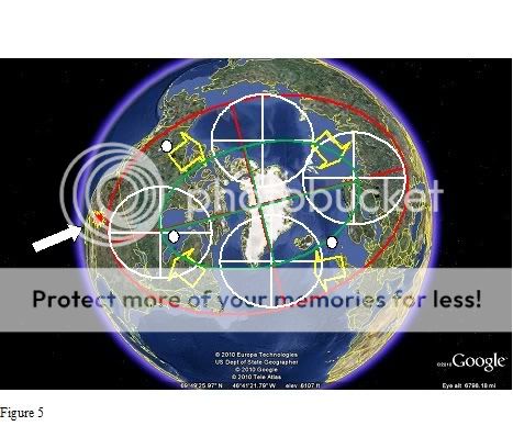
Figure 5
Below I have tilted the earth to what would be the orientation of the planet with the true north pole on Greenland with the Polar ice caps anybody in the path of the glacier would have to of migrated to get away from the three mile thick glacier (seems a bit much to me considering how little northern Greenland has melted but that’s just my thought on the matter). In figure 5 I have the Arizona meteor hit on the left which pushes the crust southward in the western hemisphere. And the easter hemisphere has to travel north it has no choice like pulling a table cloth, pull one corner and everything moves. See the three white dots they are Hapgoods points I can see this orbit being like a snail shell type of orbit getting smaller and smaller until it finally comes to rest at home. So Hapgoods Yukon location is probably spot on at some point in the cycle. Or more than likely his dots are the very first cycle. But remember the magnetic poles are not moving it’s the crust that’s moving! The icecap is never any bigger than it ever was its just getting new land under it. Much like putting a flashlight beam at the equator of a globe at south America and moving the globe back and forth across the continent.
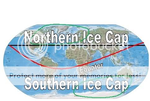
This is what I would expect to see with a 5500 km ice limit and no pole shift caps at both poles and roughly equal distance from the poles (shown in black). And with a moving pole shift in green with no great global temperature change you get Alaska and Siberia Glacier free and The Equator moves to the south in the Western Hemisphere and North in the Eastern Hemisphere (shown in red).
Just one last thing on ice caps try this experiment take a glass of water freeze it and you will notice the volume increases of course everyone knows that water expands when it freezes. Now let the glass of ice melt and of course the water level drops. Now if 90% of an iceberg is under water how much wills the water level rise if the expansion of ice is 10% while it’s frozen? Maybe it’s just me but my glass of ice water never ever overflowed if I let it melt in the sun. The Arctic ice cap is a big ice cube there is no land under it. I’ll leave it at that.
