Now read what ya just wrote and look when the last ice age was Look at the last polar displacement location The poles did not move the earth moved over them. Thats why Vega was the pole star. The whole earth is not moving and the poles staying still the poles are a result of the Corse mass not the thin layer floating on it. Cut an apple in two the skin is a scale model of the earth now just six miles of crust floating on a world of magma. It doesn’t move the crust does.
Of course this is wrong. It’s called Archimedes’ Principle, and it means that for ice already floating in the ocean, the sea levels will not change if it melt. But what will cause sea levels to change is not floating ice, but ice that sits on land masses, like Antarctica. It is easy enough to look up how much ice is on the antarctic landmass and find out for yourself that if it were to melt it would raise sea levels my dozens of meters.
Do you know how we know Vega used to be the pole star? Do you? It’s called precession. We can calculate it using basic physical principles. It does not involve the earth flipping across its axis as the magnetic field does. It has nothing to do with it.
Here is what I could find NOTE! there is a correction every four years due to a leap day which keeps the claendar in check but the times are increasing so if you disregard the date correction and observe actual times you can see that there is a six hour per year of difference. Perhapy you know of a better place to get data other than your memory.
There are four traditional seasons on Earth, marked by the movement of the sun in the sky. For the northern hemisphere:
Spring starts at the moment when the sun is directly over the equator, going from south to north: the “vernal equinox”'.
Summer starts at the moment when the sun is farthest north: the “summer solstice”.
Fall starts at the moment when the sun is directly over the equator, going from north to south: the “autumnal equinox”.
Winter starts at the moment when the sun is farthest south: the “winter solstice”.
The times in this table are Coordinated Universal Time (UTC) SPRING SUMMER AUTUMN WINTER
2000 March 20 07:35 June 21 01:48 Sept 22 17:27 Dec 21 13:37
2001 March 20 13:31 June 21 07:38 Sept 22 23:04 Dec 21 19:21
2002 March 20 19:16 June 21 13:24 Sept 23 04:55 Dec 22 01:14
2003 March 21 01:00 June 21 19:10 Sept 23 10:47 Dec 22 07:04
2004 March 20 06:49 June 21 00:57 Sept 22 16:30 Dec 21 12:42
2005 March 20 12:33 June 21 06:46 Sept 22 22:23 Dec 21 18:35
2006 March 20 18:26 June 21 12:26 Sept 22 22:23 Dec 22 00:22
2007 March 21 00:07 June 21 18:06 Sept 23 09:51 Dec 22 06:08
2008 March 20 05:48 June 20 23:59 Sept 22 15:44 Dec 21 12:04
2009 March 20 11:44 June 21 05:45 Sept 22 21:18 Dec 21 17:47
2010 March 20 17:32 June 21 11:28 Sept 23 03:09 Dec 21 23:38
2011 March 20 23:21 June 21 17:16 Sept 23 09:04 Dec 22 05:30
2012 March 20 05:14 June 20 23:09 Sept 22 14:49 Dec 21 11:11
2013 March 20 11:02 June 21 05:04 Sept 22 20:44 Dec 21 17:11
2014 March 20 16:57 June 21 10:51 Sept 23 02:29 Dec 21 23:02
2015 March 20 22:45 June 21 16:38 Sept 23 08:20 Dec 21 04:48
2016 March 20 04:30 June 20 22:34 Sept 22 14:21 Dec 21 10:44
2017 March 20 10:28 June 21 04:24 Sept 22 22:02 Dec 21 16:28
2018 March 20 16:15 June 21 10:07 Sept 23 01:54 Dec 21 22:22
2019 March 20 21:58 June 21 15:54 Sept 23 07:50 Dec 22 04:14
2020 March 20 03:49 June 20 21:43 Sept 22 13:30 Dec 21 10:02
Your right th earth does not do this I am not saying it does just the crust is moving the rest is stationary.
Since you’re just pretending, I’ll play along. If the pole of rotation didn’t move, just the crust, the pole star would stay the same. The pole star doesn’t change if you’re on a boat drifting north or south, just the apparent height of the pole star.
So if the continents had been drifting around the stationary pole, Polaris would always remain the pole star. It would apparently move higher or lower in the sky as the continents drifted north or south over the years, but would remain the pole star.
Thats not possible there is no more water on the planet than there ever was. Thats why noahs story doesn’t float Water levels were much lower see the diggerlands the landbridge connecting Europe with GB. If they melted today it would be like me throwing a one meter block of ice into an olympic sized swimming pool and thats probably too generious scale is more like 100 pools.
You make a great point your are right, quite correct. SO a planetary wobble is not out of the question but that would not rule out crust disacement if the planet were to be grazed by a meteor either. SO we have a massive planetary wobble and a disproportate crust movement. But great observation and nobody told you that came from thinking yourself well done. Ya your absolutely right.
Again, just for pretend, you do realize that the year isn’t an integer number of days, right? On the summer solstice, if we count off exactly 365 days of exactly 24 hours of exactly 60 minutes of exactly 60 seconds, we will find that we haven’t exactly reached the next summer solstice! We have to wait about 1/4 of a day until the actual summer solstice. And this is why we have leap years that insert an extra day into the calendar once every four years, except sometimes, because the year isn’t exactly 365.25 days either.
And the exact date of the summer solstice doesn’t matter, because even if you lose a quarter of a day every year, if you’re on the arctic circle you’ll know the day of the summer solstice because that will be the day the sun won’t set in the middle of summer. Your calendar might call it a quarter of a day later every year, but it won’t change the fact that there will be one day of the year when the sun doesn’t set, and one day of the year when the sun doesn’t rise.
If you drift south of the arctic circle you’ll find no days when the sun doesn’t set/rise, and if you drift north you’ll find multiple days.
You are correct about the last metaphor. However, the oceans are DEEP. Just a mere 1% increase in volume means a huge increase in sea levels. As far as your first refudiation goes, I have no idea what you’re getting at.
Yes your right but the ice caps hold nowhere near 1% of the total water mass of the planet
There is also the fact that warm water is less dense than cold water (until they approach freezing.) So a warmer planet means rising seas even if no land-based ice sheets melt.
Do you realize how much ice Antarctica has? The Antarctic ice cap is several kilometers thick in places. So the estimate is that there’s about 30 million cubic kilometers of ice on Antarctica, which makes all the other ice caps in the world a rounding error.
If that ice completely melted, we’d be looking at an estimated 65 meter rise in sea levels.
Of course, if Antarctica has less or more ice than estimated we’ll have either more or less sea level rise if it melts, and it probably isn’t all going to melt. But if it all did, our planet our would something like this: World Dream Bank: FUTURES: DUBIA, A GREENHOUSE EARTH
I haven’t the time to read all posts in this thread, but no one seems to have pointed out why Siberia and Alaska did not get glaciated in the last ice age. I apologize if I’ve missed your post about it.
The reason is simple: lack of precipitation. There was no source of water vapor for those regions. The Arctic Ocean was frozen over all year around. There was a massive glacier over Europe and far western Siberia that acted like a giant mountain range blocking storms and precipitating out most of the water vapor. In the Pacific, the storm track goes west to east, not north, so not enough snow fell in Alaska to build up glaciers, except on the mountains where it never melted.
However, it was very cold in winter in Siberia and Alaska during the ice age, colder than today.
As far as the poles shifting, they do move somewhat, but only about a couple meters per year. And they don’t move in any particular direction; it’s just a random walk. That means they may go back to where they were a few years earlier. For the OP’s hypothesis to be correct, the North Pole would have to be shifting in a definite directon for thousands of years, going from the North Atlantic to its current location in some 10,000 years. That’d require a movement of about half a kilometer per year.
The OP could probably put his mish-mash of orgasmatron science on a web page. Then nominate it for a posting on Weird Earl’s. Sort of like going from a member of the cast of SNL to a host of the show.
Or not.
By the way, I’ve been within 48 miles of the North Pole. Not that it really adds to this thread.
Just passing by.
Carry on.
Canada was nearly completely covered by ice, as well as the northern part of the USA, both blanketed by the huge Laurentide ice sheet. Alaska remained mostly ice free due to arid climate conditions. (does that explanation not make sence to anyone but me? When winter comes in Canada it may not snow at the same rate or time dut the whole country gets snow if fact the Norther worlds gets snow not just parts)
Local glaciations existed in the Rocky Mountains and the Cordilleran ice sheet and as ice fields and ice caps in the Sierra Nevada in northern California. (Local Glaciations? In the west? Spotty cold? How about this High altitude regions glaciers formed lower elevations were seasonal snow or rain because it was warmer)
In Britain, mainland Europe, and northwestern Asia, the Scandinavian ice sheet once again reached the northern parts of the British Isles, Germany, Poland, and Russia, extending as far east as the Taimyr Peninsula in western Siberia. To depths of three miles. Three miles on one side nothing on on the Alaska Siberia side?
The Arctic Ocean between the huge ice sheets of America and Eurasia was not frozen throughout, but like today probably was only covered by relatively shallow ice, subject to seasonal changes and riddled with icebergs calving from the surrounding ice sheets. According to the sediment composition retrieved from deep-sea cores there must even have been times of seasonally open waters. How is it possible to have an ice age and not have the Western Arctic Ocean freeze?
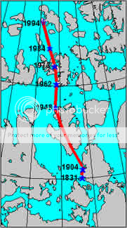
And as for 1/2 km per year of Polar shift its actually 40km a year and accelerating.
There are tree stumps on a western arctic on Axel Heiberg Island One of the larger members of the Canadian Arctic Archipelago, it is also a member of the Sverdrup Islands and Queen Elizabeth Islands. It is known for its unusual fossil forests, which date from the Eocene period. Owing to the lack of mineralization in many of the forest specimens, the traditional characterization of “fossilisation” fails for these forests and “mummification” may be a clearer description. It is clear that the Axel Heiberg forest was a high latitude wetland forest. These tree stumps are actually Spanish moss trees and are not stone the wood can be burned. That as it is Would it not be logical to assume with a three mile Ice sheet over head these stumps would not exist? The icecaps and glaciers flattened mountains and made the Northamerican Prairies but failed to crush an Island full of trees?
The Eocene was the period between 54 and 36 million years ago.
There was no ice sheet during the Eocene.
As for the contention that if it’s snowing in Canada it must also be snowing in Alaska, well, are you high? North America is a large continent. You know how there were huge snowstorms last week on the east coast? Over here on the west coast it was clear. No snow. Have you ever heard of a newspaper called USA Today? The one that has that giant weather map? Did you ever notice that weather is different in different places?
See, again, I grew up in Fairbanks. And the thing is, it never snows in the middle of winter in interior Alaska. It’s DRY. There isn’t enough moisture in the air to snow. The interior is between two mountain ranges. But go to southeast Alaska, a couple hundred miles away, and the climate is completely different. And why?
Mountains have a huge impact on local climate. For instance, you know how in Seattle it rains all the time? But go 100 miles east and it’s desert? And why do you think that happens? It’s because there mountains to the east. Moist air comes in from the ocean, and hits the mountains and is forced higher, higher is colder, cold air can’t hold as much moisture as warm air, and so all that moisture dumps out on the west side of the mountains. The air that makes it over the mountains is dry, and as it sinks and warms, it can hold on to whatever moisture it still contains. And so we have temperate rainforest on one side, and 100 miles away on the other side we have desert scrub.
There was no ice sheet during the Eocene.
I didn’t say there was ice in the Eocene period, The trees are from that period and are not fossilised they are mummified and can still be burned. How could they have survived an ice age under three miles of moving ice? They could not have. Hence no Glacier over that tract of land.
As for the contention that if it’s snowing in Canada it must also be snowing in Alaska, well, are you high?
Again that is not what I said If its winter in Alaska it winter in the whole north and snow forms on that whole area. It cannot be summer in Alaska and winter in Europe at the same time.
And you are right it does not rain or snow anywhere at similar rates. But to suggest that three miles of Ice formed on one side and none on the Alaska SIberia side defies reason. It would have snowed more in one place than others why was this not present in the East? I’m not sure how many miles of snow you would have to compact to get Three miles of ice.
I searched Google and found the Specific gravity of snow.
Freshly fallen Snow, 0.16
The specific gravity means its density as compared to water. So fresh snow has a density 0.16 times that of water.
The heavier the snow the higher the moisture content the fewer inches of snow per inch of rain. Arctic snow being much less dense and Southern snow Much heavier or denser. I lived in Nanisivik on Northern Baffin Island and the snow there is like styrofaom thats why igloos are so stable and easily built.
An average value would be 6.25 inches of snow for 1 inch of water. In the North the ratio is 10:1.
So over 18-30 miles of snow would be needed to create a 3 mile thick glacier that fell on the easter arctic and US and none in Siberia and Alaska?
Who’s on drugs?
Not having a glacier doesn’t mean that no snow ever falls there. It just means that the snow melts every summer. Trust me, Fairbanks is covered in snow every winter, it’s just that not enough falls so that it can’t all melt in the summer. Although I have come across patches of dirty ice in protected shadowy spots in June.
So, long cold dry winters with little snow, and short warm summers that melt the snow, means no glaciers. And a couple hundred miles away, where it’s warmer but wetter, you get more snow, and the longer summer isn’t enough to melt all that snow before the snow starts to fall again next winter. And then the next year it happens again, and again, and again. After a thousand years you’ve accumulated quite a lot of ice. And remember that ice and snow reflect sunlight, so a few colder than normal years where the snow doesn’t melt can mean a permanent ice cap persists and grows even when temperatures return back to normal.
And care to comment on my contention that if Fairbanks were drifting south, we’d notice?
Your focus on the exact time of the solstice is a red herring that I dispensed with.
How do you account for the fact that on midsummer nights in Fairbanks, the sun still barely dips below the horizon? If Fairbanks had drifted south that couldn’t happen.
And if Europe were drifting north, then villages in Norway that previously had been below the arctic circle, would now be above the arctic circle, and would now have true midnight sun when that never happened in the past.
How does your theory account for the fact that places below the arctic circle on the official maps are still below the arctic circle, and places above the arctic circle are still above the arctic circle?