Maybe it is just an artifact of the camera or maybe it is red?
It’s on an island off the coast of Belize:
17.569237, -88.240367
Maybe it is just an artifact of the camera or maybe it is red?
It’s on an island off the coast of Belize:
17.569237, -88.240367
I don’t know the answer, but here’s a direct map link:
Thanks, Chronos.
As it doesn’t appear that that’s in an industrial area (so, not human-made pollution), and assuming that the satellite picture is representative of the lake’s actual color, it could be due to algae or bacteria, or soil runoff if there’s a high iron content in the local soil.
FWIW, It also shows that red color on MapQuest maps./
Usually red water is an algae bloom. The Sea of Galilee turned red last year (and I think also in 2016).
Red Tide is an example of this, but I don’t know that red tide applies to inland lakes. But I also can’t tell if the lake on that island is connected to the sea or what.
Any body of water can have red algae, though.
I guess Belize’s east coast is also having an issue with sargassum, but that is brown and from everything I see is just on sea coasts.
The ground looks a weird color too? Is this possibly just something like the wavelength they image with to get through cloud cover or something?
Quoth AI (FWIW) :
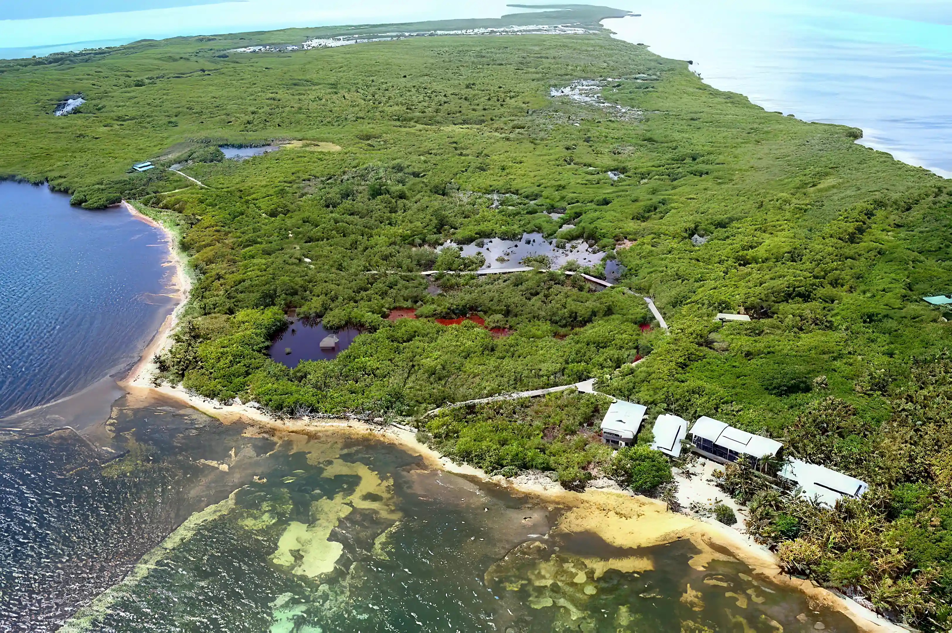
It’s tannins leaching from the bark of red mangrove trees. You can see the same color on other islands in the vicinity, like here:
https://maps.app.goo.gl/iEjB7uAsMxicbnZw9
And this drone photo of a nearby cay that shows it’s a real color, not a Google Maps artifact.
Interesting! Thanks.
Which in turn use near infrared to get the sharpest imaging of the coastline.
FWIW I’ll also quote an AI here for some interesting bit - Claude. The red may be both algal bloom and false color!
>The underlying sources do capture NIR. Google Earth’s imagery comes from multiple satellites that are multispectral:
∙ Landsat 8/9 — includes NIR (Band 5)
∙ Sentinel-2 — includes NIR and red-edge bands
∙ Maxar satellites (WorldView-2/3, GeoEye-1) — include NIR<
>Regarding the red lake:
This area of Ambergris Caye has interior lagoons and brackish ponds that are known to experience algal blooms. Specifically:
∙ The northern caye has extensive mangrove wetlands with trapped, poorly-circulating water
∙ These lagoons are subject to cyanobacteria blooms, which produce strong NIR reflectance → red in false-color
∙ Nutrient loading from nearby development in San Pedro has been documented as a stressor on these interior water bodies
Regarding the purplish land:
Northern Ambergris Caye has seen significant land clearing for resort and residential development. The purplish signature fits:
∙ Sandy, cleared, or marl substrate typical of the caye
∙ Sparse dry-season vegetation
∙ Possibly compacted or disturbed ground from construction activity<
Oh this also from Claude. FWIW.
>Near-infrared (NIR, ~700–1000 nm) is almost entirely absorbed by water, so it’s used to cleanly delineate the water-land boundary — mangroves, shorelines, and island perimeters show up sharply.<
Which, I assume, just uses the same satellite pics?
They did not look the same to me.