Not technically Chicago, but pretty close…The southwest corner of Oakton and McCormick. There are no signs up and no indication of what’s happening behind the screens and fences. But it’s a huge property, they’ve been digging and moving stuff around there for months and months. Is that the future home of some monster mall? A housing development? A quarry? I’ve seen huge piles of gravel or rock towering back there. Anyone know what plans lurk behind that barrier? Inquiring minds want to know.
I live not too far from there and drive by it a lot and also have no idea what it is. I feel like there were some structures there a few years ago that have since been taken down or some trees that were removed but my memory is fuzzy.
Here’s the satellite view, which seems fairly recent since it includes the new Floor & Decor place on the north side of Oakton. You can see where some old buildings used to be.
Ok, figured it out. It’s the site of a former coal plant of some sort that got all contaminated and now Nicor is in the process of trying to clean up the site and convert it into a sports complex.This article is from 2 years ago.
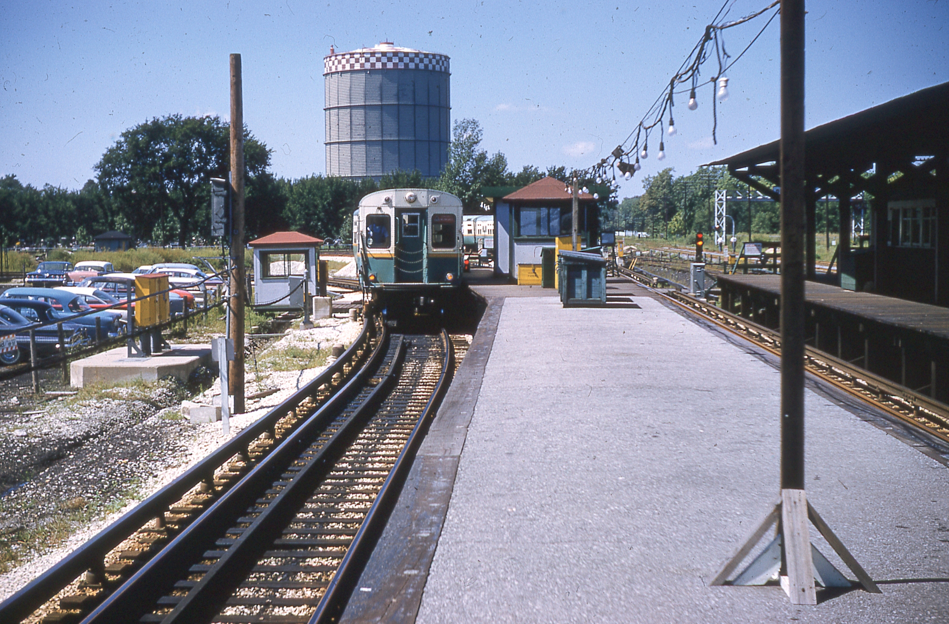
Historic Arials shows a large gas container on that site as early as 1938 and as late as 1962. I remember seeing that thing as a kid from as far away as the Hollywood Kiddieland at Devon and Lincoln and rather close up when we went to see a movie at the Sunset Drive-in at Touhy and McCormick (which is visible in the 1962 Historic Arial) It was an enormous tank, maybe 15 - 20 storys high. I remember it as being green, but I’ve always been color-blind so it may have been red or orange. I know it had a red and white checker pattern around the top and I also remember seeing a few similar tanks in other parts of the city or suburbs.
The gas container was green. You could see the top of it from the parking lot of Queen of All Saints church.
Great job, Wino! And the Sunset Drive-in! I had totally forgotten that place, too. I guess it’s no wonder they don’t put up any type of sign. What would they say? “We’re cleaning up a toxic area here. Stop in and look!”
Okay, seems I’ve made a small error. There was in fact a large gas container on the site at Oakton and McCormick. It was not however, the big green (thanks rowrrbazzle) one that I was thinking of which was much larger and situated about three blocks south at the corner of Pratt and Kedzie (roughly on the spot that would eventually become a Dominck’s Finer Foods store). I can’t find a photo of it anywhere but it was similar to this one that was in Maywood. I found an interesting article about such gas containers written by a John R. Schmidt who says the container at Pratt and Kedzie was the largest of these in the Chicago area. It was built in 1926, it was 362 feet high, 254 feet in diameter, and held over 15 million cubic feet of natural gas.
One curious note: If you look back at the Historic Arial from 1938, there is a pilot assistance arrow painted on the top of it which points northwest and reads, “Chicago Curtiss Airport 9 miles”. Does anyone know exactly what or where Curtiss Airport was?
Googling suggests it was an early name for Glenview NAS.
And I’m not finding the navigation arrow or the Pratt-area tank in 1938. It is east of the golf course/Warren Park and north of Rosehill Cemetary?
I did find the tank in the 1938 Skokie photo.
And, finally, that Dominick’s location will reopen as a Cermak Fresh Market in a couple days.
–That looks about right. Thanks jnglmassiv.
–No, you’re thinking of the Dominicks at Pratt and Ridge (across the street from S&C Electric). There was another Dominicks on Pratt about a mile west of there.
–From there, follow the canal south until you get to Pratt. It’s on the southeast corner of Pratt and Kedzie.
–That’s the one on Ridge and I’m looking forward to it. I live not to far away and the area needs some competition when it comes to grocery stores.
The slaphead smilie doesn’t seem like punishment enough. I lived right there at Pratt and Ridge (& Damen) as a kid and simply skipped right over the Kedzie part, thinking I knew what you were talking about.
It took about 20 minutes to find my block and house in 1938. I’m out in Jeff Park and, without a nearby river or the Kennedy and other contemporary landmarks, it isn’t too easy. That was before it occurred to me that I can do the scrolling with the 2007 images and THEN roll back the clock. Slaphead again. I count about 5 or 6 houses on both sides of the street. There were whole city blocks with no apparent structures within a half mile of me, neat.
There was an addition put on my house in antiquity and it seems that it was there in 1938.
Chicagoland is enjoying what amounts to an explosion of local grocery chains lately.
I’ve never been to a Cermak but I’m sure it will be nice.