In William Gibson’s Neuromancer, he posits that future America will form the “Boston Atlanta Metropolitan Axis”, a giant urban sprawl that merges the entire East Coast from Boston to Atlanta into a single megacity.
I’m interested in modern megalopolitic sprawls where you can go for miles on end without ever leaving urbanity. For the purposes of this question, I’m going to define a rural area as one that is largely dedicated to agriculture or wildlife preserve but not parklands like Central Square Park or Golden Gate Park and the journey only counts if you are at least a mile away from any rural area along most of the route (certain bottlenecks due to natural features are allowed if it’s only a few miles).
Houston: From roughly around Sugarland on the West to Baytown on the East is about 50 miles New York: Starting from around Medford on Long Island, going west through Manhatten, then Newark down to Edison, NJ is about 100 miles Los Angeles: Starting from San Bernadino and going to Van Nuys is about 100 miles. Tokyo: Starting from Gunma in the north, going down through Tokyo and Yokahama through to Hiratsuku is about 100 miles Guangdong: Starting from Aotou harbor, going through Shenzhen, then Guandong through to Foshan is about 150 miles
Are there any other epic urban sprawls of this magnitude?
If you drive from Stoney Creek, Ontario to Oshawa, Ontario (taking you through Toronto) you can drive 85 miles or so and never leave city. Depending on how you define “urban” you can argue that I should push the starting point back to St. Catharines, which makes it about a hundred miles.
Northwestern Germany and the Netherlands has almost no real rural area at all in the sense a North American would understand the term. You can drive a hundred miles in any number of directions and never see rurality. If you rented a car in Bad Honnef, south of Bonn, and then drove north through Bonn, Koln, Dusseldorf et al. all the way to Oberhausen you’d have gone 65 miles and never seen country. You could then go east towards Hanover probably another 80-90 miles and taking the right route see city and town the whole way. It’s probably the most densely populated large place in Europe.
Manila is a pretty epic sprawl, too, stretching at least 80-90 miles north to south.
I’d say that the North/South in the Houston axis is longer- you go clear from Galveston to just south of Conroe before you see anything really rural, for a distance of nearly 90 miles.
Even D/FW is only about 66 from the east side of Rockwall, to the west side of Ft. Worth.
True, but there are also a few stretches along 95 that I would describe as “rural”. Providence to Groton is very sparsely populated, and from there to New Haven there’s just the standard seaside tourist towns.
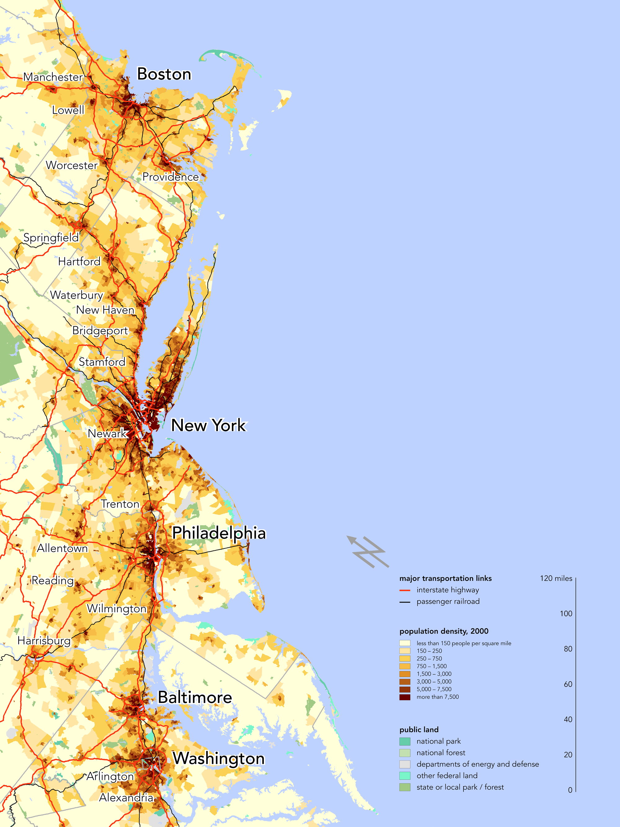
Going by this map of population density, there are a few routes along BosWash with less than 250 people per square mile, and more routes with less than 750 people per square mile. This US census map of “urban” areas (large PDF) seems to show a few gaps between urban areas in the Northeast (which are “rural” by the 2010 census definition).
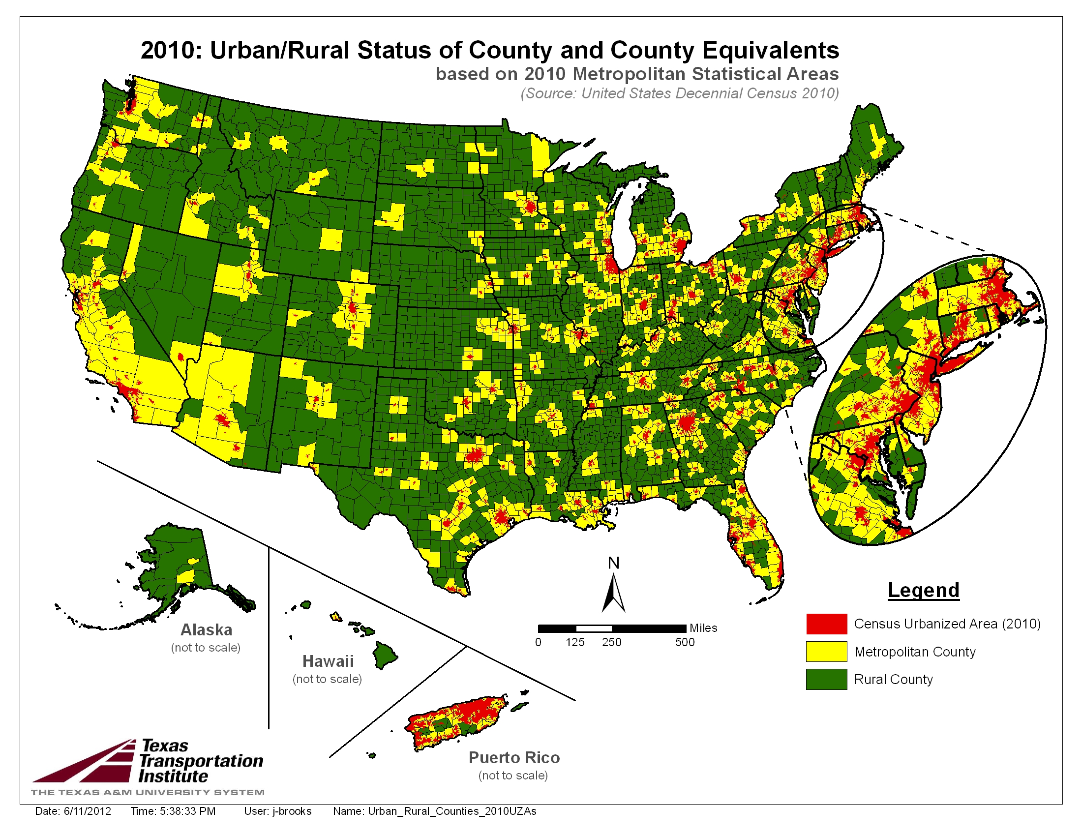
This map may be of interest. You can get from Maine to North Carolina while staying in counties that are part of metropolitan areas (in yellow on this map). What you’re talking about is probably closer to what the Census calls “urbanized areas” (in red on this map). In that case there is a short break between Worcester and Springfield and another between Wilmington and Baltimore. The resolution of the map is not the greatest, but it looks to me like the longest continuous stretch is from about Northampton, Massachusetts, to about Elkton, Maryland.
(Side note on that map: I’d need more resolution but it looks like there might be a spot where you could drive due north from the Mexico border and get to Canada without ever being in a “metropolitan county”.)
I don’t know what that map is showing.
If you look at Arizona, aside from the big metro areas of Phoenix and Tucson, the entire rest of the state is what I would consider “rural.” If you look at that map, it says that Mohave county is “Metropolitan,” and I can assure you that it’s mostly desert…
I’m a city boy and when I was on my learner’s permit, I drove around between Stoney Creek and Grimsby on the back roads. That’s rural. I imagine the stretch between Grimsby and St. Catherines has rural patches as well.
I think it’s from the US census definition of a “metropolitan statistical area”. From here, it is defined as any county where the majority of the *population *lives in or commutes to a city.
In the denser areas of the east coast, that seems to make sense as most of those yellow areas are filled with suburbs and small cities, by area and population. In Arizona the definition doesn’t make quite as much sense, since there are vast areas where exactly nobody lives.
Yeah, eastern San Bernardino county in CA and northern Washoe county in NV are very empty of people and urban accessories, altho they appear as part of a metro area.
Not to disagree, but only to clarify: A big part of the problem is that they’re basing the map on COUNTIES. And the ones out west are gigantic and empty, as compared to the east. I’d expect that the Census Bureau would have enough professional statisticians to realize how stupid that is. Good enough for government work, I guess.
In the Salt Lake City area, there’s near-continuous development from Brigham City to Spanish Fork, about 100 miles by road. Geographical constraints force most of the development north and south rather than east and west, which is why it’s so long.
The Census Bureau doesn’t define the statistical areas. That’s up to the Office of Management and Budget.
There’s also a significant rural gap a few kilometres wide between Whitby and Ajax, on either side of Lake Ridge Rd. Though Ajax in particular is doing its best to fill it in. And the Ministry of Transport is building a north-south freeway parallel to Lake Ridge Road to connect the 401 and 407. it. So along Highway 2 it may crust over with plazas and gas stations over the few years, but right now, it’s still rural. Other than that, it’s solid suburbs along Highway 2 from east of Townline Rd in Oshawa all the way into Toronto.
This question is confusing based on the definitions used. New Jersey and Rhode Island may not have any wholly rural counties but both of them have rural areas (even hear of the New Jersey Pine Barrens? Rhode Island is a tiny state but is has farms, quaint seaside towns and even islands without many people). The Northeast is much more town oriented than most of the country in both its outlook and statistics. I live south of Boston near I-95 and I-495. There are plenty of rural areas around if your definition of that means large woodland spaces, scattered farms and lots of nature but it is localized. You will never be more than a few miles from a town center with some amenities but it is certainly not urban in any meaningful sense of the word. Some of it is suburban, some is exurban and there is a lot of protected conservation land where you can walk for many miles and never see another person let alone a store or a road if you want to.
I know people talk about the BOS-WASH corridor like it could be considered to be a single city but it isn’t at least according to my definition. I-95 may seem like almost continuous development from Washington to NYC but there are definitely less developed stretches once you hit New England. Much of the development that you see in some areas is only there because of I-95 (you need rest stops, convenience stores and gas stations at exits) but it certainly isn’t urban all the way through. Once you get just off of the main highways, there are plenty of really small towns and you don’t even have a chance to get off in the truly rural areas because they don’t build exits there.
Don’t do that because it will mislead you. I live in the Southern-Western Boston area because I cannot stand urban areas in general. It is straight-up exurbia here. There are cattle and horse farms down the street. I can walk straight out of my back door and only encounter pure wilderness for at least 5 miles if I take a certain trail and I can extend that to 20+ miles just by crossing over a couple of roads along the way. If you died out there, nobody would ever find you. I live directly in the path of what people call the BOS-WASH corridor and it isn’t true at least in this area. It gets broken in parts of New England. Once you go north out out of Boston into New Hampshire or Maine, things can get truly remote by any standard. A Lear jet crashed two hours from Boston in 1996 and it still took three years for anyone to find it. That was just by luck from a random hunter.