Is there a specific reason why the northern part of continents are wider than the Southern portion? Australia widest point is closer to the beltline, but it is tapered as well. I don’t know what shape Antarctica has underneath the ice.
The Earth is a globe: up and down, north and south, were chosen arbitrarily. Look at a map upside down. Why are the continents wider on the bottom?
IHNFI, but would guess that it has more to do with ocean currents and their direction.
Yes, it isn’t true,
Australia is narrowest in the north.
Europe is such an irregular shape and such an arbitrary area that you can’t really say that it’s narrower in the north or south. In strictly geographic terms the distance between Western Siberia and and Norway is slightly less than the distance between Georgia and Portugal, so Europe is narrowest in the North.
Africa’s narrowest point is at the tip of Morocco, in the extreme north. The distance between Tunisia and Morocco is about the same as the distance across South Africa. So in no sense is Africa widest in the North.
Asia is more-or-less regular. I guess you could argue that the NE tip of Siberia is slightly less narrow than than southern tip of India, but India isn’t the extent of Southern Asia, which stretches across the Indian ocean to the Malay Peninsula, making Asia much narrower in the North than the South.
If you include Central America as part of North America, then North America is narrowest in the south. However is you include Central America as part of South America then neither of the Americas are widest in the North. It’s completely arbitrary where you wish to delineate North and South America.
Trying to define “north” for a continent that lies at the South Pole is kinda futile.
So we have no continents that are clearly widest in the north, one that is clearly narrowest in the north, three that are so irregularly shaped that you can’t really say which is widest but that are technically wider in the south, two where they may be widest in the north based on an arbitrary delineation and one where the question makes no sense.
Out of six major landmasses (North America, South America, Africa, Eurasia, Australia, Antarctica), the first three show the “fat top, south pointing tail” pattern to some degree, and the last three really don’t. Eurasia looks like it might if you’re looking at a flat map but that’s just an artefact of the projection. Antarctica’s pretty circular.
That’s not much data to build a theory on.
This threw me. The site appeared reputable but the content was patently absurd. They don’t post a disclaimer?
Here you go: Antarctica Travel Guide | Tripreport
Most maps stretch out landmasses toward the poles - the closer to the pole, the more the land gets stretched out. There is more land north of the equator than south of it, so the north ends of those landmasses get stretched out on a map projection. It’s much less noticeable on a globe.
Of the six continents (considering Eurasia as one), North America, South America, and Africa might be considered to narrow southward.
Australia, especially when one includes New Guinea (which is geologically part of the same land mass), narrows northward.
Antarctica, being almost centered on the South Pole, necessarily has its narrowest part, the Antarctic peninsula, directed northward.
Eurasia is so irregular that it can’t be considered to narrow in any particular direction. However, India, which originally was a separate landmass, narrows southward.
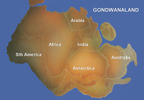
Given the small sample size, the continents can’t be said to show any particular pattern. And some of the relationships in any case are not independent, but are due to the way that the ancient continent of Gondwandland broke up. The continent was roughly oval, and broke up mostly into wedge-shaped pieces. The fact that South America, Africa, and India narrow in the same direction is due to the way that Gondwanaland, by chance, split up.
I would guess that the shapes of continents have absolutely nothing to do with ocean currents, that is, the shapes of continents do not depend on ocean currents.
On the contrary, I would guess that ocean currents are dependent on continental shapes as well as the orientation and location of the continents.
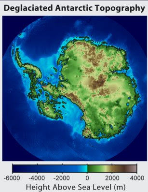
That shows Antarctica with its ice cover intact. Here’s an image of a deglaciated Antarctica.
I think it is possible to come up with an objective standard. North and south do have meaningful definitions based on the planet’s rotation. So draw a dividing at the halfway point between every continent’s northernmost and southernmost point. Then determine what percentage of its area is on each side of this dividing line.
Doing some rough visual estimates from my globe, I’d say all of the continents have more area north of their equator than south of it. North America, South America and Africa all have approximately twice as much are in their northern half. Eurasia also clearly has more area in its northern half although maybe not quite as high a percentage. Australia appears to be pretty evenly split.
This was worth going to the link: "Fortunately, gravity pulling towards the centre of the earth prevents the landmasses from falling off into space, and instead they slowly slide. "
heh heh heh
The current shape of the continents is an artifact of time and perspective. Hundreds of millions of years ago, the land masses looked very different from what they do today. Here’s an animation of the breakup of pangaea. Before that there was gonwanda. Before that other configurations. In the future, the continents will move more in other and totally new ways.
This is due to plate tectonics, not ocean currents.
I’m surprised this hasn’t been brought up more in this thread.
If you look at a flat, rectangular map of the world, the relative size of various features is going to be distorted. Look at a map of Antarctica (or look at it on a globe).
Now look at a world map, and note how much different Antarctica looks - it’s all long and thin.
When you try to represent the entire surface of a spherical object on a two-dimensional space, it’s going to get distorted.
It’s not a very reputable theory. ![]()
“My theory, which is to say the theory that is mine, and which is attributable solely to me …”
I would assume this to be common knowledge, and it’s being taken into consideration. Yeah, I know, “never assume.”
A lot of maps, esp maps of the world, are drawn according to the Mercator projection: http://en.wikipedia.org/wiki/Mercator_projection
<hijack>
If you’re interested in another perspective, research the Peters projection (also called the Gall-Peters projection)
</hijack>