I disagree. Eliminate the prominent ridges and terraces caused by the mining process (which would happen eventually), and an open-pit mine looks like a natural feature - look at the pic you provided. The fact that it is huge doesn’t detract from that.
Long, straight (or gently curving) cuttings simply don’t exist in nature, and scream out as human-made. I can’t find a really nice pic, but anyone who has driven (say) the highway up to North Bay …
By living, not a Western lifestyle, but in a way that was adapted to the environment, which European settlers considered backward, “savage” and uncomfortable, to say the least.
I think someone once said that, if you looked at where the population was concentrated, Australia was more of an archipelago than a continent. Just as so much of the Canadian population is concentrated along the northern edge of the great plains, so much of the Australian population is concentrated around the southern and eastern coasts.
However, the Canadian government (just like the BLM and its predecessor stateside) made the lands available for sale and homesteading to encourage settlement.
The problem is more the availability of good farm land. In places like Missouri and Illinois the good land passed to private owners 150+ years ago; in Nevada nobody wanted most of the land because it wasn’t suitable for agriculture. The same thing happened in Canada; it’s just that Canada has more land that wasn’t suitable for agriculture.
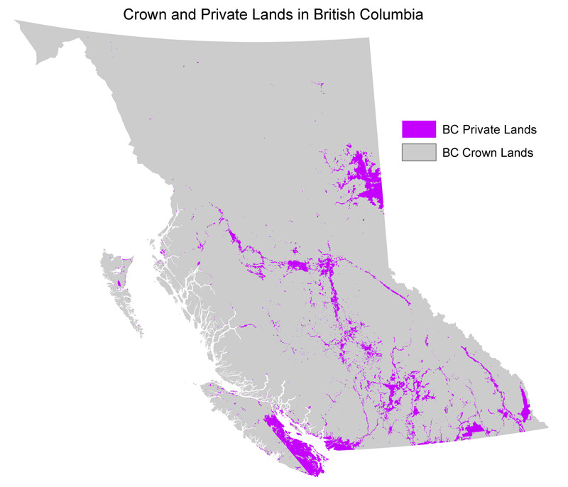
Perhaps I’m being “wooshed” (and if so, joke’s on me ;)) But if you are serious … you have it backwards. Much of Canada is Crown Land because no-one wants to live in it.
It is not the case that the government of Canada is discouraging population growth by keeping much of Canada as Crown Land.
It was considered a “primitive” lifestyle by other native Americans.
Farmers everywhere consider themselves better off than hunter-gatherers (though to be fair, the reverse is also true - the difference is that, if they come into conflict, the farmers tend to have the numbers on their side).
The notion that pre-Columbian native Americans were all hunter-gatherers or nomads living in tune with their environment is an odd one: in terms of numbers, the majority were always farmers (often living in large agricultural villages - or even cities like Cahokia).
Not a woosh and I don’t buy that argument for a moment. Look at the map I posted - are you saying nobody wants to live in 3/4 of Vancouver Island (which has some of the highest real estate values in the world) and that land basically has zero value? Please.
I think Canada’s land practices are deeply regressive, favor the entrenched elites, and one of the reasons why Canada never became the powerhouse that the U.S. became.
Understood, but today’s society is not that agriculture based. Maybe people just want to fan out from the big cities and be able to live and work in the same general area / society where they grew up (which they cannot do in many cases due to real estate prices). It’s impossible to test the theory that “nobody wants that land” because people aren’t allowed to vote with their dollars. I think people absolutely would want that land.
Most of Vancouver Island is extremely rugged, so yes, that probably is exactly the case.
The city of Vancouver has some of the highest real estate prices too, yet if you go due North just a few miles the development stops quite abruptly. This is because it’s not good land to build a city on, not because the government was so mean and wouldn’t let people build one there.
And once the railroad was open, it was effectively used to transport twenty-five constables and sixty men under arms from the Winnipeg Field Battery to the Rat Portage War, whereas without the railroad, it would have taken far longer for them to arrive, given the Shield (not the Manitoba officer’s shields, or the Ontario officer’s shields, but rather The Canadian Shield).
Hey, there are hundreds of places in Canada where the land prices / distribution just doesn’t pass the smell test. If you think there are no social consequences to having the same lot cost twice as much in Canada vs. the US., I don’t know what to say.
No, there is no other road. The roads that head north do not connect eastern and western Canada. Even the winter/ice roads do not connect eastern and western Canada.
The best that you could say is that if some closed logging roads were re-built and and if a bridge were built at 49°09’35.0"N 88°18’09.0"W, then there would be two roads connecting eastern and western Canada – one a paved highway, and the other a rugged track in the bush. But one can’t even say that, for the closed logging roads are not even close to being drivable and the bridge that could be built does not exist.
It was a new bridge that failed – the roadway popped off the abutment at one end on the first fairly cold winter day, as in a couple of trucks going SHIT LE MERDE in a Bo and Luke Duke jump of a couple of feet vertical.
It was not a deep freeze. It was just the first normally cold day of winter. There was no strong winter storm – just a typical snowfall with typical gusts. We do get strong winter storms off of Superior, but that night was not even close to a strong winter storm. Since the bridge should have been built to withstand strong winter storms and the deep freeze, but spectacularly failed on its first normally cold winter day in normal gusts that typically go with normal snowfall here, the only rational conclusion is that the bridge was not built correctly. What is in question is whether it having not been built correctly is as result of defective bolts, defective installation, or defective design. Blaming it on the environment would be ludicrous.
The old Nipigon bridge lasted seventy-nine years, and had its roadway rebuilt only a few years ago, so it could have lasted decades more, but is being replaced so that the highway can wisely be twinned. The new bridge did not survive the first normally cold winter day. If that isn’t an prime example of a bridge not being built correctly, I don’t know what it is.
Fair enough – I interpreted “not built correctly” as “not engineered correctly”. If you interpret the phrase as simply meaning that something was wrong with it, then obviously, yes, something clearly was – kind of implied when I said “obviously it shouldn’t have happened”.
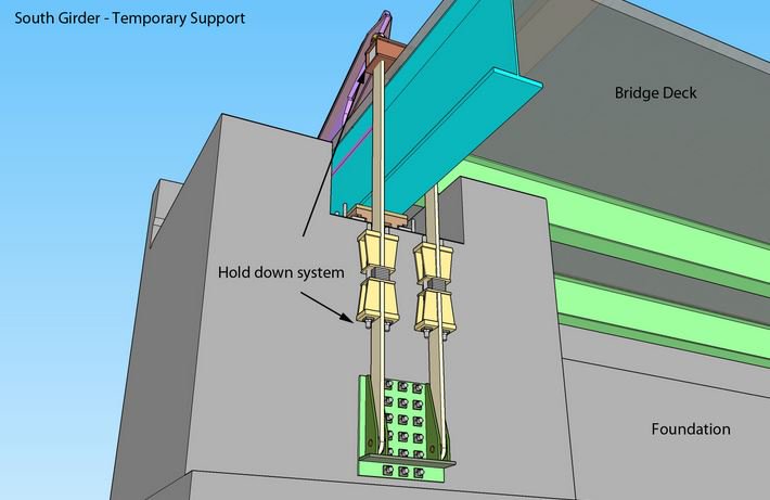
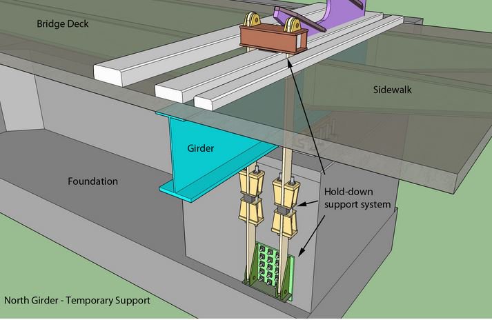
They’ve strapped it down. Makes sense to me. When the cables above contract, have something underneath counter it. It will be interesting to see if the temporary fix becomes something more than temporary.
Here are a couple of diagrams that illustrate the temporary repair.
All y’all do realize, of course, that if the Geraldton and Schreiber folks can’t get to Nipigon, and the Nipigon folks can’t get to Geraldton and Schreiber, there won’t be as many opportunities for our population to grow.
PARTS of Vancouver Island have very high real estate prices. Parts don’t. Land that is very steep, rugged, hard to build on, and far from services (like hospitals and grocery stores and electric utilities and good roads) is far less desirable.
However, the cities were largely developed in an era when agriculture and transport were the main determinants of location. No big cities developed in the middle of Nevada or the middle of the Canadian Shield, and one would not develop now even if all the land was magically free because there’s no critical mass of infrastructure. Without agriculture and an already-developed economy, what would most people DO out in the middle of nowhere? How much of that Crown Land is actually located within say twenty miles of an already developed urban area from which people can fan out?
And there are plenty of places in the U.S. where that is true as well. The feds own 43% of California; San Francisco land prices are still insane. The feds own two-thirds of Idaho and Utah, and more than three quarters of Nevada. There’s nowhere near as much difference between U.S. and Canadian land policy as you imagine.
What “same lot” costs twice as much in Canada as in the U.S.?
Part of it is that, AFAIK, there were no ice sheets covering Australia like there was in the US during the last ice-age, we had land-bridgesbetween mainland Australia, Tasmania and New Guinea but little glaciation.
While we have had some volcanoes, most have been long extinct or dormant and with no major tectonic plates cutting through the main landmass there aren’t chains of active or recently dormant volcanoes like in the US.
Putting it in US terms, the arid zone gets, on average, 9.8 inches of rain in a year, and semi-arid gets up to 13.7 inches of rain over a year.
Looking at this site: Average Annual Precipitation by USA State - Current Results, only one state (Nevada) would be classed as arid and three (Arizona, Wyoming and Utah) are semi-arid with New Mexico and Montana close but still above the mark.
Australia could certainly support a population of say 80 million. There are quite a few huge temperate areas which are currently undeveloped. Take a look at the size of Cape York compared to Java. Cape York has a monsoon climate, it could support intensive rice cultivation with multiple crops a year. Of course that would involve clearing vast amounts of area which are protected rain forests, which no one wants to do. Similarly East Gippsland and most of Tasmania is completely undeveloped, but again also protected wilderness areas.
A few Australian politicians have floated the idea that Australia should aim to reach a population of 50-60 million as quickly as possible by raising immigration quotas in order to remain “relevant” on the world stage. They’re pretty much a minority however, I think most Australians are comfortable with our current population and want slower growth.
I think you’re confusing Vancouver Island with the City of Vancouver on the mainland. It’s the city which has some of the highest prices, not the Island.
And one of the reasons is that the city is hemmed in by ocean and mountains. That means there is not a lot of available land for expansion, so land prices in Vancouver are high.
But that’s exactly what’s happening with the major cities on the prairies (Regina, Saskatoon, Edmonton, Calgary, Winnipeg). They are steadily expanding, as farmers who own the lands around the cities (not the Crown) sell the land for development into housing and industrial development. The prices are set by the market, not by the Crown.
An understanding of the relative populations of Canada and the USA can be fairly quickly grasped by simply ignoring the border entirely and imagining it was one big country.
If you do so, the layout of the population is simple and obvious; where it is logical to have many people, there are people. Population is to be found along rivers, lakes and natural ports, preferably in places where agriculture and pastoral farming were once possible. The US-Canada border does NOT cause the population to drop; Toronto is by far the largest city on Lake Ontario, Montreal’s a huge city well north of Boston, Vancouver is as big as Seattle, and there are more people in Alberta than in Montana, Wyoming, North Dakota, and South Dakota combined.
Where the population begins to dwindle is not at the border, but where the land starts getting cold and difficult, which is, depending what longitude you’re at, some distance north of the border. Most of Canada is simply not suitable for people to live in. Ellesmere Island is as big as Great Britain but is only slightly more hospitable than Mars.