Only if you insist that north-south axes must be displayed vertically. When you are looking at a map in which the latitudes and longitudes are not displayed as straight lines at right angles to each other, why would you?
North != top and south != bottom. And that’s true in life as well as on this and many other maps.
Here in NC Lenoir is not in Lenoir county. Henderson is not in Henderson county. But Durham is in Durham county. And we have Transylvania county for Dracula fans.
This reminded me of one that happened a while back. Not my misconception, happily, but a patron who showed up trying to find the building for her job interview. She had the address written down for the building, and at first glance, it certainly seemed she was close, but something seemed off. I used Google maps to confirm my suspicion, and sure enough: the address she had, if it were correct, would have been the middle of a parking lot nearby. I told her that I didn’t know what had gone wrong, but recommended that she call her contact and get the correct address and make clear that she was trying to get there in time for her interview. She rushed out, dialing her cell phone, and I never saw her again.
She’d been gone for about 5 minutes when something clawed its way up from the back of my mind, and I pulled up Google again. Sure enough: the address she had was 100% correct for the building she was looking for, only it was the address for the department of whatever it was in Mecklenburg County, VIRGINIA, 200 miles away from the Mecklenburg County she was standing in. There are only two Mecklenburg Counties in the US, and she was in the wrong one.
To this day, I don’t know if she Googled the wrong place or if she’d driven to the wrong county, but either way, even if I’d remembered to check that while she was right in front of me, she wouldn’t have gotten there in time for her appointment.
There have been several mentions about the size of Texas in this thread. A friend of mine originally from Alaska told me they’ve had their share of Texan blowhards throwing their weight around. Alaskans would tell them “Watch your mouth or we’re going to split in two and make you the third largest state in the union!”
Madagascar! That’s surprising because it is a big-assed island, and it’s pretty much the only thing off the east coast of Africa. Thing is, for some reason I keep shifting it over to the west coast in my mind. Maybe they should move it?
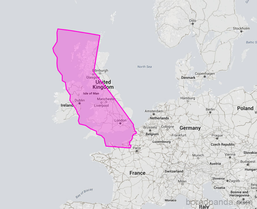
One of the biggest culture shocks I got was when I got to college and students from the East Coast talked about taking a day trip to another state! Growing up in the Bay Area, driving anywhere out of state and back is a multi-day affair.
This has been pointed out to me before, but I still can’t get my mind around the idea that the distance between Sydney and Melbourne, Australia, is comparable to the distance between New York and Cleveland. They look so close togother on the map!
Also that New Zealand and Australia are as far apart as New York and Oklahoma City.
But Madagascar just naturally wants to sit under the big bulge in the northwest of mainland Africa. If it were down there then the whole continent+island would be much more balanced.
LA for me, but same story. You could drive to the state line and back in one day, but not with much time left for doing anything. We could day-trip to Tijuana if you got up early and came home late.
A few years ago when my parents came to visit for Christmas, my Dad wanted to visit his friend in the Monterey area, and maybe do a few touristy things while we were there. He knew it was too far to drive there and back in one day, so he said he’d take care of booking a hotel for us. He booked just one night. I had to tell him even then, we’d basically have enough time to drive there, have dinner with his friend, spend the night at the hotel, and turn around and drive back to my place the next day (particularly since I wanted to take then on the scenic route down Highway 1 and make some stops on the way). I guess there would have been time for a couple hours of sightseeing the next morning before heading back, but not time to see a whole lot. He changed the hotel reservation to two nights.