I remember reading a geography book as a child and seeing a cool photo of an orange grove where the orderly lines of trees had been displaced by movement along a fault. I’m pretty sure it was this photo.
Does anyone know exactly where this photo was taken? Are there still displaced treess along the fault line like this? I had a quick look on Google Maps but my eyes started glazing over looking at orange groves.
Thanks, Duckster. From looking at Google Maps today it appears there are no orange groves around Calexico these days. Just lots of ploughed fields, but I’m not sure what the crops are.
Is that the Pacific on the lower right corner? This picture might be reversed. The SAF is a transcurrent fault, shifting the west side of California northwards, if I’m not mistaken.
In case anyone is interested, and happens to be visiting in or near Palo Alto, CA:
There is a small park up in the hills to the west where there are many visible artifacts of the 1907 San Francisco earthquake. One is a barbed wire fence that was broken, with one end of it shifted several feet away from the other piece. There is also a little sag pond, and other evidence. There is a fairly short hiking trail there that winds around the area, and a small parking area with a little box that has self-guided brochures (if they still have the money to keep supplying them).
Drive up Page Mill Road, it’s on the right just about a half mile or so (IIRC) before you reach Skyline Blvd at the top.
Looking at the little creek bed that runs through the lower right of the photo it may be a natural part or tributary of the New River that flows to the north and west out of Caleixco, which might narrow down where that orange grove was. Unfortunately the only solid Google hits for Trenuing Fault are the captions for that photo.
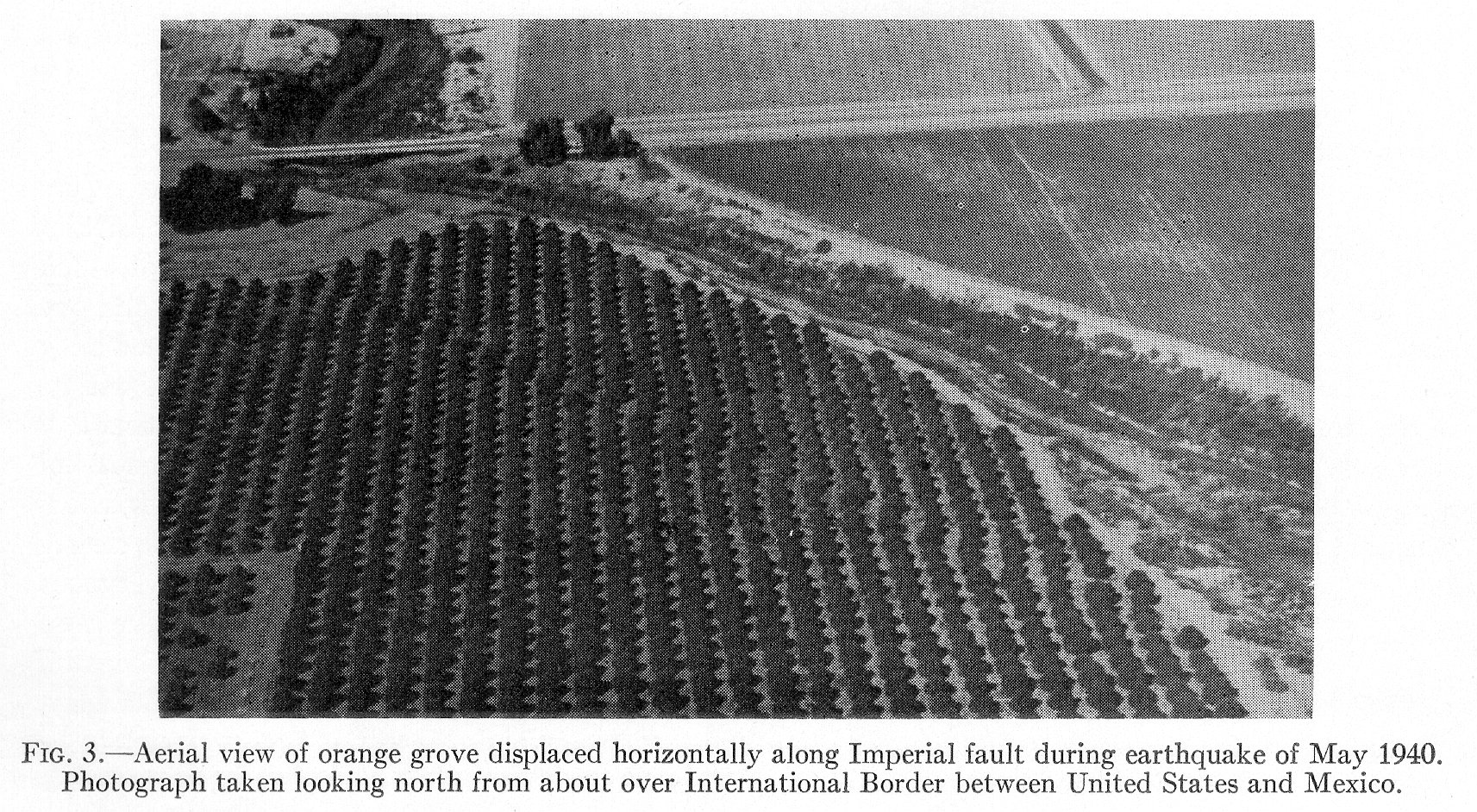
I found this photo which is clearly the same orange grove, but taken from a different angle. This is captioned as the Imperial Fault, and the photo is described as being taken from the north from roughly over the US/Mexican border, which means the first photo was taken looking west, and the creek runs SE-NW before turning N after passing under the road.
Looking at the shape of the creek, I think it might be here, in which case that interesting orange grove is now a landfill site.
(If so then it looks like the creek now takes a loop to the south before going under the road, when before it went fairly straight. Compare the field boundary heading north from the road just east of what is now the car lot to the east of the bridge, and the remnants of the clump of trees to the south of the road which is also visible in the old photos.)
Yes, that photo of the displaced fence jogs my memory circuits. I was wrong, above, in calling it a barbed wire fence. It is a wooden fence as shown in your photo.
Good find on the picture, but I don’t think that’s the right field. If you pull up a overlay of the local fault lines on Google Earth (couldn’t find a Google Maps version, sorry) you see that the Imperial Fault runs east of the city of Calexico, not west. I think it’s this field; the Imperial Fault line runs directly through it, and it would be visible “looking north from about over [the] International Border”, as described by the caption in the picture you found.
The strike-slip plate boundary between the Pacific Plate and North American Plate is often refered to in general terms as the San Andreas Fault, even when it splits into multiple smaller faults, which I believe is what the Trenuing Fault is. The parts of Southern California to the west of the SA fault are on the Pacific Plate (and thus moving northish instead of southish like the rest of the US), even though they are sometimes pretty far from the Pacific Ocean.
Back in 1968 friends and I were camping in Ocotilla Wells in the Anza Borrego desert in southern California. Late one afternoon a 6.5 earthquake hit and the epicenter happened to be just below Ocotilla Wells. Our old station wagon was rocking side to side so hard that it almost came off the ground. We had to sit down because the shaking was so bad. I’d been in earthquakes before, but never outside in an open area. It looked as though the mountains were moving up and down. The quake made the news, but it wasn’t a big deal because it was centered in the middle of nowhere.
We left the next day, but were delayed because highway 78 to Los Angeles had cracked open. Bulldozers had to come in a make a temporary dirt ramp because one side of the highway was about 3 feet higher than the other side.
Good sleuthing, that has to be it. Don’t know why I didn’t notice that creek when I was looking at the map. Shame the trees are no more though, that was a cool field.