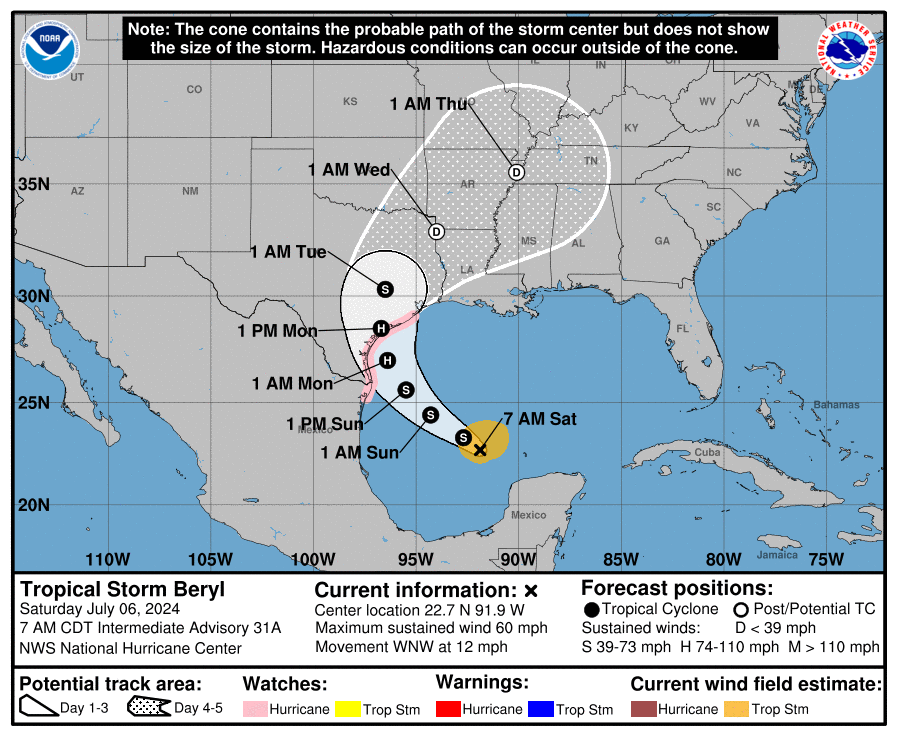
I thought I would start a general thread for hurricanes this season:
With winds up to 50 mph and thus not a hurricane:
Some areas of Texas could get up to 5 to 10 inches of rain, while some areas of Mexico could get up to 20 inches of rain.
I thought I would start a general thread for hurricanes this season:
With winds up to 50 mph and thus not a hurricane:
Some areas of Texas could get up to 5 to 10 inches of rain, while some areas of Mexico could get up to 20 inches of rain.
It’s going to be a very bad year. The water has been quite hot, and that’s fuel for storms.
They are saying that it could be a hurricane by tonight.
We are still in June. Hurricanes used to come in August.
As of Saturday afternoon Beryl became a hurricane. And now on Sunday morning it’s a Cat 3 “major” hurricane striving towards Cat 4.
With AL96 following in its wake about 6 days behind.
As to @Moriarty …
IMO … there are three factors which make a hurricane season “bad”: quantity of storms, intensity/duration of storms, and the luck of if/where they interact with land. We have had seasons with lots of big bad storms and almost no impact on any people; just fish and some trees.
To be sure, if we have above average quantity, intensity, and duration, then we’d also need above average good luck on location to avoid above average human impacts.
So far I’m not aware of any quality research on the statistical differences, if any, on storm tracks between intense and non-intense seasons. Nor how AGW may be altering the seasonal-scale track patterns.
I’m not suggesting track patterns aren’t changing; I just don’t know one way or the other and I suspect nobody does. Yet.
I mention this most seasons, but here are two blogs I follow during season in addition to the NHC official stuff. They are definitely not running in real time, often lagging the situation out there by 12-36 hours with updates tucked in where needed. But both of these are much longer on the why’s and the bigger picture context than is NHC who is (appropriately) all about the “what now and what immediately next”.
IMO the sum of all three provides a well-rounded view of the total tropical picture.
These folks are about climate change first and foremost but while a tropical cyclonic storm is in progress anywhere on Earth, they also run a play-by-play on that, but still within a climatic context.
And for a mostly Florida-centric POV, this local TV newscaster’s blog is the polar opposite of the usual vapid TV weather-reader with fake teeth and fake credibility to match.
I see reporting that it’s already made it.
One of those 3 - intensity/duration of storms - is going to be unusually high this year. The Atlantic has been at record high temperatures, and that is kindling for storms.
Agreed. I expect both a high storm count and a high ACE number for the year.
But that’s only suggestive of a year of great damage and carnage. That was the point I was reaching for but didn’t quite make explicit. Or explicit enough.
The research that I’ve seen – which isn’t the most recent but is probably still valid – concludes that high sea surface temperatures in the North Atlantic basin show a high correlation with hurricane energy but not consistently with hurricane frequency. The reason might be because the same climate factors that create high SSTs also create hurricane-disrupting influences like wind shear. IOW, hurricanes may or may not form more often under these conditions, but when they do, they’re likely to be more powerful and damaging.
Seems like the experts always predict a higher than normal hurricane season. A not so subtle connection to the Global Warming phenomenum.
What I never see (but admittedly I don’t look for it) is a report card on the experts predictions.
Nor do I see is a post-mortem on how well the models performed for predicting the hurricane paths (spaghetti models). Does the European model perform better in a 72 time period but another model does better for a 120 time period.
What I never see (but admittedly I don’t look for it) is a report card on the experts predictions.
Climate models don’t have either the spatial or temporal resolution to perform particularly well on local short-term phenomena like specific hurricane prediction. What we do have, however, is strong correlation, long-term trend predictions, and an understanding of the underlying climate mechanisms. In the graph below, “PDI” is the hurricane Power Dissipation Index, a metric developed by hurricane researcher Kerry Emanuel for measuring the destructive force of hurricanes, and “HADlSST” is the annually averaged sea surface temperature (Hadley Centre SST):
What I never see (but admittedly I don’t look for it) is a report card on the experts predictions.
The NHC publishes very detailed report cards every year. And updates their methods based on lessons learned.
CNN doesn’t bother with a weeklong special on that report card but it’s on NHC’s website.
Weather geeks and weather scientists are all over this stuff.
I’m on my phone so I’m not gonna dig up cites.
And yes, they have predicted below normal seasons recently. Right now the El Niño / La Niña (“ENSO”) signal can overwhelm the steady upward drumbeat of AGW. As AGW accelerates that may stop being true. Net of how ENSO itself may change in an ever-hotter world.
The other factor is that the definition of “normal” is redefined upwards every decade. IIRC 2 years after the decade turns, so on 2012, 2022, 2032, etc. Now the period of record defining “normal” is 1990-2020. Back in 2021 it was 1980-2010.
Here in the Anthropocene, “normal” is a moving target.
Hurricane Beryl has ripped off doors, windows and roofs in homes across the southeast Caribbean after making landfall on the island of Carriacou.
Earliest Cat 5 ever. (well in more than a century)

"It's hard to communicate how unbelievable this is."
Brian

Beryl's next stop will be in Texas, where the storm is forecast to make landfall early Monday as a hurricane. Should the storm stall over the Lone Star State, heavy rain and flooding problems could become extreme.
This fellow is a blogger who’s also a Houston-based meteorologist. SO Beryl is right in his home territory.
He has plenty of quality aoutput over the yeas on every hurricane, but if you’re a Texan or Louisianan, he might be an especially good resource to follow. Whther for Beryl or any other future GOM storm.

Headlines Beryl’s track forecast narrows a bit on the Texas coast; still expected to make land as a hurricane Monday. Beryl trying to put itself back together, but has a ton of dry air to bat…
Awesome thanks I am book-marking that fella.
Going to be a damp few days here in H town fortunately not looking Harvey or Alice like and will move on through quickly .
There is also spacecityweather and both sites reference each other

How are Houston people doing ?
Lots of wind in the early hours and rain, Lots of bits of branches down ( we are just outside 8 on the west near Buffalo bayou so it went over us) . Power went out just after mid day and Comcast just went out now. Nice blue sky’s and it’s quite pleasant for July in Houston.
Fortunately we have a generator to keep things going.
How are Houston people doing ?
I’m not in Houston, but a friend of mine just moved from Chicago to the Galveston area two weeks ago (bad timing!). She reports a lot of wind and rain, but that their power never went out, and they aren’t experiencing flooding, at least.