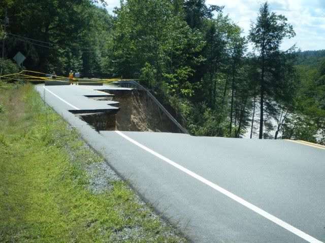
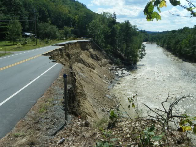
After Hurricane Irene, we have some washed out roads in Vermont. How would you go about fixing them, after seeing the pics posted below? The State doesn’t know what to do, nor do I. Do you appreciate the aesthetics of the steel guard rail dropping off over the new river banks? Or how the pavement has disappeared like a Tetris game.
You can move to the left as Terr said or you can fill it in and shore up the side against the river. If Boston and Hong Kong can fill in parts of their harbor and build skyscrapers on it, I’m sure you Vermonters can figure out how to fill in a hole and build a road across it.
Yeah, I think anyone from CalTrans or Colorado DOT would be a little amused at the idea that “no one knows what to do.” You blast out a little more of the mountain to create a new shelf.
ISTM that curving it to the left would involving buying up the properties on that side of the road. The public doesn’t tend to take well to eminent domain (but they do tend to forget a few months later). Besides, that might end up eroding away as well.
I’d think the best way would be to build a retaining wall on the river side, backfill it, and lay a new road on top of that. Done properly and anchored well it shouldn’t wash out again since this time, since it’s man made, it’ll have proper drainage built in. Now, after a heavy rain, instead of absorbing all the water and collapsing it’ll just let it all out into the river.
I thought that was a bit odd as well. My first answer was “Maybe ‘the state’ should look up ‘engineers’ in the phone book and ask one of them.” Looking at the picture, I’m bit surprised they let it erode that close to the road without doing anything about it. That looks like an accident waiting to happen. It seems like before it collapsed they could have setup a giant “A” shaped form (on pilings), poured concrete (with drainage holes) into it, pulled the form, backfilled the space with gravel and probably been good to go.
That’s basically what I’m suggesting now, but it’s just that they’ll be starting from scratch and they’ll have to remove all the rubble first.
It’s not like this is the only road in the country that rides 50 feet above a river. They don’t have to re-invent the wheel here.
Why not build a bridge over the bad area? Treat it just like you would any ravine or gorge that’s in the way of a road.
Seems like that would be easier than trying to fill it in with 20,000 dump trucks worth of dirt & fill. Anytime you fill a hole that huge it’s never as stable as undisturbed soil.
I bet that area washed out because it was fill dirt. Maybe not man made fill. It could have been deposited there over a period of hundreds of years. It’s just dirt sitting in a hole with rock under it. A flash flood can wash it out pretty easily.
Moving the road away from the edge is the least expensive option, and the only practical one. You have pretty good evidence that the road was too close to the edge already. The state may already have a right to the property. Borders formed by waterways aren’t fixed. They may have a right to use the land a certain distance in from the riverbank, and the river just got a little wider right there.
I’m no civil engineer, but I’d be willing to bet that building a bridge would be far more expensive and time-consuming that either of the other options which have been floated here (filling in the eroded area, or moving the road to the “left”).
Possibly excavate to sound soil, then fill with possible anchoring systems and placement of rip rap. Or retaining wall and fill.
The problem is that rivers always have and always will erode their banks and change shape. That area just downstream may get washed out at the next flood event.
Most likely that bank was native soil and quite possibly tree covered. I have seen 100’ + sections of river bank with old, native trees be washed away due to flood waters.
Rivers are powerful things and don’t traditionally stay in one place.
It’s a weak spot in the road that doesn’t look much different from the rest of the road edge. They can support the river edge with boulders, which is the cheapest way at a few cents per pound or they can come in with equipment and drive tong and groove steel pilings deep in the ground. Then everything can be backfilled with stone and gravel up to the road.
I’m not sure why the OP thinks VT doesn’t know what to do. They fixed similar washouts on Rt 4 and Rt 100 by dumping lots of fill and building retaining walls. They’ll do the same here.
As others have noted - the least expensive method would be to simply move the road and repave a bit further from the river. However, if they want to keep it in the same location, then mechanically stabilized earth is a likely solution - essentially backfilling behind a retaining wall, and then building on top of it.
Ironically, they will first need to do some excavation to cut the slope back and create a haul road down to the river bank so they can get equipment down there safely. Then they can start filling in with fill and rip rap from the bottom up. They can also install soil stabilization as they work their way up.
Yes, sems to me they would start at river level, put in a wall that the river won’t undercut, and build it up in steps. A lot of roadwork I see has those giant wire cages full of big rocks as the wall. Backfill behind it. Step upward and inward. If necessary fill with crushed rock rather than soil to enhance the drainage. As others point out, drainage! Put a few pipes under the new road so water accumulating on the uphill side ditch drains quickly and cleanly away from the road instead of soaking in. Presumably also have a few gravel-filled channels in the bank on the way up to drain any water accumulating in the deep soil.
Even if they do move the road over to the left through Charlie’s front yard, they will still have to do something like I describe to stabilize the mud cliff, or it’s going through his backyard next hurricane.
I’m guessing this is covered in civil engineering 101.
Well, let’s put it this way. The bridge by my house was temporarily destroyed by Irene. It took us two days to find another route to civilization, and it required driving a half hour in the wrong direction, then backtracking. And I’m in one of the more heavily populated areas of Vermont. It was weird to have all these places that used to be within walking distance (well…“all” meaning like three - small town) now be a 45 minute drive away, even though I could see them across the river from my front yard.