Here we go. After a very slow burn start, Debby is coming to absolutely drench Florida. Current prediction is Cat 1* (85mph) at landfall (just a little to the left of where Idalia hit and that area still hasn’t fully recovered from that). Right now the center of the cone is about 50-60 miles east of me. Guess I know what I’m doing tomorrow - I don’t have anywhere near enough wine in the house for a hurricane.
Thanks to my job, I’m also working part-time this weekend since the EOC has activated (sitting on conference calls).
The wind shouldn’t be that bad (although tornados are always a concern when a storm comes in). What we’re mostly worried about right now is absolutely torrential rain. A significant chunk of the Big Bend is in the 8-12" category over the next 5 days. Localized rainfall could be MUCH higher. The damn thing is forecast to stall right after landfall so we could be looking at a Harvey-type situation and our water table is already near or at capacity, so flooding is a real concern especially for low lying areas.
* But don’t look away. From the latest NHC forecast discussion:
With the spun-off loop current eddy sitting right off shore - although a bit west of the expected path - Debby is going to have plenty of hot water to use should she wish to put her party clothes on. Surface water temps along her path are running 88-90 degrees F.
TLDR version: If you live in the Big Bend region of Florida, buckle up and watch the advisories. Normal hurricane stuff (check your batteries, fuel, emergency supplies, etc), but be aware that there is a significantly enhanced severe flood risk with this storm. Be smart, be safe.
Is a CAT-1 storm something to be that worried about? I mean, I get it is a serious storm but Florida has been through many that are worse and I would assume a CAT-1 for most Floridians should be, after some precautions, a Netflix and chill night.
Well, yes. It’s not a “major” hurricane, but it’s still winds of 75+ mph for hours, damaging storm surge of several feet or more along most of Florida’s Gulf Coast, and huge amounts of rain.
And, as noted above, it’s anticipated that it’s going to be very slow-moving, meaning that’ll it just keep blowing, and raining, over the same areas for many hours.
From a wind standpoint, not too bad. Big worries are storm surge on the coast and tornado spin-offs inland. But keep in mind that North Florida (and especially the Big Bend area) are heavily forested. Wind at pretty much any level above ‘stiff breeze’ can bring down limbs and weaker trees - this is especially true when the ground is saturated (which it is). This leads to widespread power outages and with the heart of the dog days on us, that’s no joke.
Also, as I said, for this particular storm, flooding is the big worry. We’re already wet, which means the water will mostly go to runoff. They are saying some rivers could be in flood stage for weeks following the storm.
My son is near Gainesville. He loves when storms happen. He hangs his plywood shutters, grabs his go bag, and heads to work.
He works in a prison. Storms cause people to call off. He volunteers for all the OT they’ll allow him, so he cleans up financially. He has a cot in his office just for these situations.
ETA: the prisoners tend to behave during storms. Locked up in cells, it’s common for them to fear flooding.
Yeah, looks like they are in the 8-12" band, but might be 6-8" which where Tally is now. It’s also looking increasingly likely that the storm will undergo at least some rapid intensification, so probably Cat 1 at landfall, maybe Cat 2, but that seems less likely to me. She’s big and that tends to slow that sort of rapid speed jump.
The basic question has already been covered. Here’s the bigger picture …
NHC is coming around to the idea that wind speed, and hence the famous 5 Categories, is a terrible way to describe the hazards hurricanes, typhoons, cyclones, etc., represent. Wind is the least of the major factors that drive deaths and property damage.
I’m on my phone so I’ll quit early here, but there’s lots more to be said on this point.
Thinking on it more I wonder about how prepared people are for extreme weather in their area?
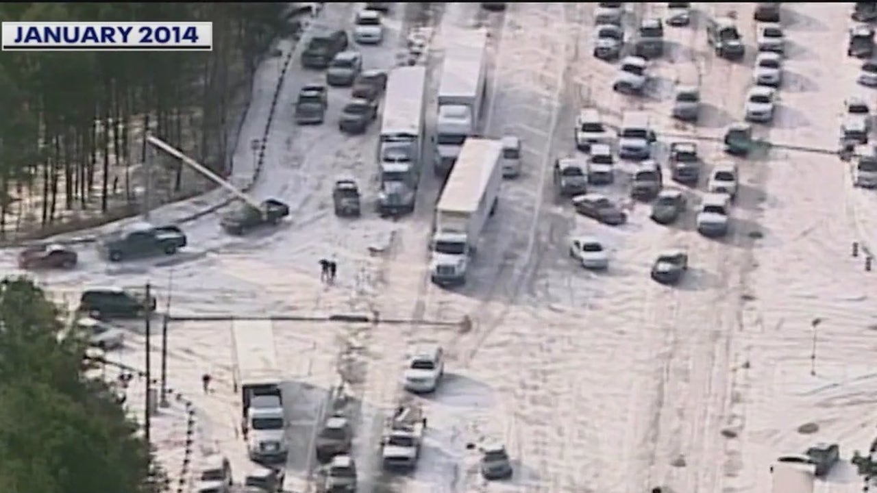
I remember some 10-years ago there was a freak snow storm in Atlanta which dropped something like 1" of snow. In Chicago, no one would blink. It’d barely be an issue. In Atlanta, it was Armageddon. The highways looked like some post-apocalyptic scene with abandoned cars everywhere on the highways. (see below)
But, Atlanta is not used to such things. The drivers are not used to it, the city does not have plows and salt trucks.
So, I would think Florida, which regularly gets hit by hurricanes, has building codes to make sure homes will survive the “milder” ones (Cat 1-2) and that cities have built their infrastructure to handle some storm surge and a lot of rain.
Of course, a big storm will always cause trouble, same as in Chicago or anywhere. But the damage can be mitigated.
Although, I have heard insurers are bailing out of Florida so, maybe they do not have these basic precautions. I do not know.
New and rebuilt construction has improved building codes especially at the coast where stilts are required and have recently been made higher for new construction. Like anywhere there, it’s a mix of stuff built before the codes, stuff rebuilt after but not to code, and new construction that is probably to code, but code enforcement hasn’t traditionally been a strong suit.
We generally do know how to stage resources for power restoration, but if miles of line are down, that takes time no matter how many bodies you throw at it.
And as said above, any system is going to have limits and a foot or more of rain is not something we generally expect or plan for.
And the line crews can work only when the wind is below a certain speed, assuming they can even get to the necessary areas despite downed trees and other debris blockades and roads closed by flooding. Then, too, if one or more transmission lines get knocked down, that would be the first priority before the distribution lines feeding end users get fixed.
@Zakalwe covered the issues from the individual property owner’s perspective. This part …
Is sorta different.
The only way to deal with storm surge is to build everything, including roads, 10-20 feet above the calm water level. Or move everything back 5 or 10 miles from the beach. You want to bury all utilities for wind hardening, but you want them 20 feet in the air for flood hardening so the power or telecom conduits or sanitary sewers don’t fill with corrosive seawater.
Draining rainwater is easy in places that have natural slope. But when 10" of rain falls on every bit of 1000 square miles of suburbia, and the height difference from highest to lowest point is 4 feet, and all of that is below the surge-driven sea level at the moment, nothing like normal traditional civic drain engineering will work.
Like the rest of the southern US, the vast bulk of everything near shore was built from just after the great Depression to the 1980s. With the huge surge in the 1960s and 1970s. And the whole place was built on the cheap, both private and public stuff.
New stuff is getting built and built better, but the vast stock of old stuff remains. And yet the sea rises.
I thought insurance companies bailing on the state might be some kind of bullshit but now I can see why they want to leave.
If Debby will just hover and pour rain down and wash a lot away it is bad for the insurer (not to mention the residents…most importantly the residents).
Florida is very much the canary in the coal mine on this.
The deeper issue is that all over this country, the political situation with homeowner’s insurance forces the price to be half, or maybe just 10%, of the cost of the true risks being run. And even more so for those risks associated with climate change.
And the politicians will not permit the insurance companies to double, much less 10x, everyone’s premiums. Which is what it would take for economic sanity to prevail. So insurers leave a market rather than be forced to sell insurance at a loss.
Of course with things like hurricanes or earthquakes or major ice storms, they might profitably sell insurance at low premiums for 10 years, then lose it all and then some in one big blast of bad luck. The problem of course is if the regulators did allow premiums to be raised enough, for each of those first 9 years the insurers would be booking world-record-breaking profits. Which would incense the electorate. Nobody would notice the 10th year where the industry lost back all of their profits to a decade-long break-even.
This is very similar to the situation with wages or retail prices under continuous slow inflation. Everybody tries to hold the line as their frog is slowly boiled. The it takes a massive obvious politically unsettling jolt to move wages / prices back to the same real value they had e.g. 10 years ago.
Stuff has been incrementally underpriced, and re-underpriced, and re-re-re-underpriced for so long that only a massive shake-up can solve the problem.
Like the FEMA flood insurance situation, most of the people running the risks cannot possibly afford to insure them at the true cost. So either the government subsidizes their premiums somehow, or the people do without insurance, hope they get lucky, and rely on (stingy) government handouts if they’re unlucky.
The USA has been steadily building this giant shaky pyramid of mispriced incentives since right after WWII, so ~80 years of accumulated wrongheaded thinking and wrongheaded building and wrongheaded 3rd and 4th generation landowners & residents.
Last night = Sat night, I passengered into Miami at about 9pm. There were holding delays as rain bands with t-storms would pass over the airport stopping the operation, then move on and they’d restart the flow of airplanes until the next band arrived to pause everything again. Very typical situation for anyone in the outer to middle periphery of a tropical cyclone.
The arrival and landing itself were windy & rainy, but nothing out of the ordinary. I left the airport at about 10pm and encountered only light rain & modest wind for the hour-ish drive north to home. It had obviously been raining harder than that everywhere in town before I was driving. But I didn’t see any ponding in the usual low spots. So the rate and collective volume was well within our local drainage capabilities.
Today now at 3pm the ocean has whitecaps and ~3 foot surf, it’s distinctly blustery, and is since sunrise it’s rained twice for about 10 minutes with no great vigor. I also drove about 20 miles with the top down on the convertible and the sun blasting down, so not a bad day overall. The webcam at the local tourist beach shows people sitting, swimming, wading, and surfing. Right now the sky is pretty gray that way, as the next band is approaching.