[quote=Issued by The National Weather Service
Denver/Boulder, CO]
2:54 pm MDT, Wed., Apr. 15, 2009
… WINTER STORM WATCH REMAINS IN EFFECT FROM THURSDAY EVENING THROUGH SATURDAY MORNING…
SNOW IS LIKELY IN THE MOUNTAINS ON THURSDAY BUT IS NOT EXPECTED TO BECOME HEAVY UNTIL THURSDAY NIGHT. THIS COULD CONTINUE WELL INTO SATURDAY MORNING. THE FOOTHILLS AND SOUTH PARK WILL SEE A RAIN-SNOW MIX INITIALLY… WITH HEAVY SNOW EXPECTED TO COMMENCE AFTER MIDNIGHT ON THURSDAY NIGHT CONTINUING INTO SATURDAY MORNING. POSSIBLE SNOWFALL ACCUMULATIONS COULD RANGE FROM 18 TO 36 INCHES FROM THE DIVIDE EASTWARD.
[/quote]
Glad I’m taking Friday off from work. Though my Wife is going to Denver on Friday.
It may be a long weekend.
I talked with a friend at NOAA last night and he said that this is as big a storm as the one a few springs ago when we got almost 40" here and one place in the foothills got 96" (8 feet). That one was earlier in the year and it was colder. This one all depends on the temperatures - it’s 41° F right now and if it stays in the
40’s all day we are in trouble.
This is just about the perfect storm scenario for us (minus the cold) - a closed low forms in the four corners region, moves across northern New Mexico and then just sits on the NM-CO-OK border for about a day, pumping moisture from the gulf right up against the mountains. Perfect upslopeconditions.
This isn’t all that bad - it will mean that we are above average again for snowfall and all the resevoirs will be full again. Another beautiful summer in Colorado. Forecast highs for Monday and Tuesday are 59 and 64 repectively, so even with a mojor dumping, it will all be gone next week.
I was in Nederland, CO for Easter when a big storm hit. It was coming down too hard to make it back down to Boulder. Some folks took me and Kid Kalhoun in for the night and we were sphincter-deep in it by morning. It took hours to dig my car out. But when we finally made it down the mountain, it was just rain.
Well, it got as high as 42°F at around 8AM. Now it is down to 37. Looks like we’re in for a long couple of days. They issued a winter storm warning at 11:30 for tonight through noon Saturday. That’s a 36 hour timeframe.
A-Basin will be open until May at least, so this will freshen things up quite a bit.
Highlands, Copper, Loveland, Silverton, Winter Park and Wolf Creek are all still turning lifts. I wish I could be back out there, but I’ll have to content myself with hitting Tuckerman and Gulf of Slides then next few weekends.
We’re not expecting more than 8-12" cumulative down here. It’s dumping right now, but I’m still not sure if I’m or about it.
I’m in my 5th month of snowshoeing for fun & exercise on the weekends, and I admit it might start to get old in a few weeks. Especially since we’re not going somewhere warm for off-season this year.
There are places with 70-degree days in January that do not have snowstorms in mid-April, snowstorms in May, snowstorms in September, snowstorms in October…
I’ve plowed once, and I’ll have to plow again today. So far we got about 2 feet. And it’s snowing again. When it gets lighter out, I’ll take a few pics.
Damn, I love our big snow storms. Sucks I’m in India where it’s not dropped below 100 in a month. I’ll be back by June but my chances of getting stuck in a huge snow are notably diminished, though not entirely demolished.

 or
or  about it.
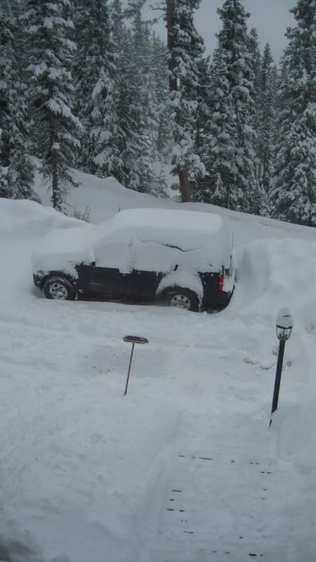